
Ross-shire
This article needs additional citations for verification. (December 2011) |
Ross-shire | |
|---|---|
 Coat of arms | |
 | |
| Sovereign state | |
| Country | |
| County town | Dingwall |
| Area | |
| • Total | 3,089 sq mi (8,000 km2) |
| Ranked 3rd of 34 | |
| Chapman code | ROC (as part of Ross and Cromarty) |
Ross-shire (/ˈrɒs.ʃaɪər/; Scottish Gaelic: Siorrachd Rois) is a historic county in the Scottish Highlands. The county borders Sutherland to the north and Inverness-shire to the south, as well as having a complex border with Cromartyshire – a county consisting of numerous enclaves or exclaves scattered throughout Ross-shire's territory. Ross-shire includes most of Ross along with Lewis in the Outer Hebrides. Dingwall is the traditional county town. The area of Ross-shire is based on that of the historic province of Ross, but with the exclusion of the many enclaves that form Cromartyshire.[1]
For shrieval purposes the area was first separated from the authority of the sheriff of Inverness by Act of Parliament during the reign of King James IV, the sheriff to sit at Tain or Dingwall.[2][3] Sheriffs were seldom appointed, and further acts of 1649 and 1661 restated its separation from Inverness.[4][5][3] The 1661 act also clarified the area encompassed, based on the pre-Reformation Diocese of Ross.[5][3] Sir George Mackenzie's Ross-shire estates were transferred to Cromartyshire by a 1685 Act of Parliament (repealed 1686, re-enacted 1690).[1]
The Local Government (Scotland) Act 1889 provided that "the counties of Ross and Cromarty shall cease to be separate counties, and shall be united for all purposes whatsoever, under the name of the county of Ross and Cromarty." The two counties that became the single local government county of Ross and Cromarty, which continued to be used for local government purposes until 1975, although Ross-shire remained as the postal county for the mainland part of the local government county until 1996.
In 1975, Ross and Cromarty was itself replaced by the Highland region and the Western Isles, under the Local Government (Scotland) Act 1973. The region became a unitary council area in 1996, under the Local Government etc. (Scotland) Act 1994.
There was a Ross-shire constituency of the Parliament of Great Britain from 1708 to 1801, and of the Parliament of the United Kingdom from 1801 to 1832. In 1832 it was merged with the Cromartyshire constituency to form the Ross and Cromarty constituency.
Geography

Western Ross-shire, also known as Wester Ross, is typified by its mountainous Highland scenery, especially the Torridon Hills which includes such peaks as Beinn Eighe and Liathach. The highest point in the county is Càrn Eighe at 1,183 metres (3,881 feet). It contains a long, fractured coastline along The Minch and Inner Sound (opposite Skye), consisting of a number of isolated peninsulas split by sea lochs; from north to south the chief of these are Loch Broom, the Scoraig peninsula, Little Loch Broom, Gruinard Bay, Rubha Mòr peninsula, Loch Ewe, Rua Reidh/Melvaig peninsula, Loch Gairloch, Loch Torridon, Applecross peninsula, Loch Kishorn, Loch Carron, Lochalsh peninsula, Loch Long, Loch Duich and the Glenelg peninsula which is shared with Inverness-shire.
The eastern half (Easter Ross) is generally flatter, and consists of towns, villages and farmland bordering the Moray Firth. In the north Dornoch Firth separates the county from Sutherland; near the Dornoch Firth Bridge lies the thin, tapering Ness of Portnaculter peninsula. In the north-east can be found the hammerhead-shaped Tarbat peninsula which is shared with Cromartyshire; across Cromarty Firth lies the Black Isle (actually a peninsula not an island), which is also shared with Cromartyshire. To the south-east Beauly Firth forms the border with Inverness-shire.
The county contains numerous lochs, the most prominent of these being Loch Ailsh, Crom Loch, Loch a' Choire Mhòir, Loch Fada, Lochan Gaineamhaich, Loch Cluanie, Loch Loyne, Loch Monar, Loch Mullardoch, Loch a' Bhealaich, Loch nan Eun, Loch na Leitreach, Loch an Laoigh, Loch Calavie, An Gead Loch, Loch an Tachdaidh, Loch Sgamhain, Loch a' Chroisg, Loch Clair, Loch Coulin, Loch Fhiarlaid, Loch Dughaill, Loch Coultrie, Loch Damph, Loch Lundie, Loch na A-Oidhche, Loch Maree, Loch a' Ghodhainn, Loch Ghaineamhach, Loch Bad an Sgalaig, Loch a' Bhraoin, Loch Fannich, Fionn Loch, Loch na Sealga, Loch Eye, Loch Glass, Loch Morie, Loch Ussie, Loch Achilty, Loch Garve, Loch Luichart, Loch Achanalt, Loch Meig, Loch Droma, Loch Glascarnoch, Loch Coire Làir, Loch Vaich, Loch a' Chaorunn, Loch na Caoidhe, Loch Beannacharain and the Orrin Reservoir.
Lewis is the northern part of Lewis and Harris, the largest island of the Outer Hebrides and the third largest in the British Isles after Britain and Ireland. Due to its flatter, more fertile land, Lewis contains three-quarters of the population of the Western Isles, and the largest settlement, Stornoway. To the west lie the isolated and uninhabited Flannan Isles. About 71 kilometres (44 miles) north of the Butt of Lewis lie North Rona and Sula Sgeir, a remote group of islands which are included within Ross-shire.
Islands
Mainland
- A' Ghlas-Leac
- An Garbh-Eilean
- Black Islands
- Crowlin Islands
- Eilean a' Chait
- Eilean a' Mhal
- Eilean an Inbhire Bhàin
- Eilean an t-Sratha
- Eilean Bàn
- Eilean Chuaig
- Eilean Dubh Dhurinis
- Eilean Furadh Mòr
- Eilean Horrisdale
- Eilean Mòr
- Eilean na Bà
- Eilean na Bà Mòr
- Eilean na Beinne
- Eilean na Creige Duibhe
- Eilean nam Feannag
- Eilean nan Naomh
- Eilean Stacan
- Eilean Tioram
- Eileanan Dubha
- Fraoch Eilean
- Fraoch Eilean Mòr
- Glas Eilean
- Gruinard Island
- Isle of Ewe
- Kishorn Island
- Làrach Tigh Mhic Dhomhnuill
- Longa Island
- Sgeir a' Bhuic
- Sgeir a' Ghair
- Sgeir an Araig
- Sgeir an Fheòir
- Sgeir Bhuide
- Sgeir Bhuidhe
- Sgeir Chreagach
- Sgeir Dùghaill
- Sgeir Fhada
- Sgeir Ghlas
- Sgeir Maol Mhoraidh
- Sgeir Maol Mhoraidh Shuas
- Sgeir na Trian
- Shieldaig Island
- Strome Islands
- Ulluva
Lewis
- Àird Orasaigh
- Bearasaigh
- Bhuaile Mhòr
- Bràighe Mòr
- Bratanais Mòr
- Campaigh
- Ceabagh
- Ceabhaigh
- Cealasaigh
- Cliatasaigh
- Craigeam
- Cruitear
- Cùl Campaigh
- Eilean a' Bhlàir
- Eilean an Tighe
- Eilean Àrnol
- Eilean Beag a' Bhàigh
- Eilean Bhàcasaigh
- Eilean Bhinndealaim
- Eilean Chearstaigh
- Eilean Chalaibrigh
- Eilean Chaluim Cille
- Eilean Cheòis
- Eilean Dubh a' Bhàigh
- Eilean Fir Chrothair
- Eilean Liubhaird
- Eilean Mhealasta
- Eilean Molach
- Eilean Mòr a' Bhàigh
- Eilean Mòr Lacasaidh
- Eilean Mòr Phabail
- Eilean nan Uan
- Eilean Orasaidh
- Eilean Orasaigh
- Eilean Rosaidh
- Eilean Sgarastaigh
- Eilean Shìophoirt
- Eilean Teinis
- Eilean Thinngartsaigh
- Eilean Thòraidh
- Eilean Thuilm
- Eilean Trosdam
- Eughlam
- Eunaigh Mòr
- Flannan Isles
- Fleisgeir
- Flodaigh, Lewis
- Flodaigh (Outer Loch Ròg)
- Fuaigh Beag
- Fuaigh Mòr
- Garbh Eilean
- Geile Sgeir
- Glas Sgeir
- Gousam
- Great Bernera
- Grèineam
- Hairsgeir Beag
- Hairsgeir Mòr
- Lada Sgeir
- Langaisgeir Mòr
- Lewis (part of the larger Lewis and Harris island)
- Linngeam
- Liongam
- Lìth Sgeir
- Little Bernera
- Màs Sgeir
- Pabaigh Beag
- Pabaigh Mòr
- Riosaigh
- Seanna Chnoc
- Sgeir a' Mhurain
- Sgeir Dhail
- Sgeir Dhearg
- Sgeir Ghlas Bheag
- Sgeir Ghobhlach
- Sgeir Leathann
- Sgeir Liath
- Sgeir Mhòr Shildinis
- Sgeir Mol Srupair
- Sgeir Sgianailt
- Sgeir Tanais
- Sgeirean An Arbhair
- Shiant Islands
- Siaram Bostadh
- Siaram Mòr
- Tabhaigh Bheag
- Tabhaigh Mhòr
- Tamna
- Tanaraigh
- Tannaraidh
- Thalta Sgeir
- Vacsay (Bhàcasaigh in Gaelic)
North Rona
-
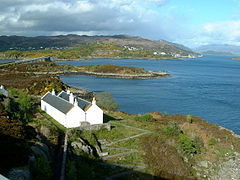 Eilean Bàn from the Skye Bridge, looking towards Kyle of Lochalsh
 -
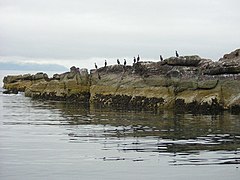 Shag birds on Longa Island
 -
 The Isle of Ewe
 -
 Cave on Garbh Eilean, Shiant Isles
 -
 The famous Callanish Stones on Lewis
 -
 Seana Chnoc (at left) and Bearasaigh from the south west. Stac nam Balg is just visible to the left of Seanna Chnoc


Settlements
Mainland


- Achnasheen
- Alness
- Applecross
- Ardgay
- Aultbea
- Avoch
- Ballintore
- Barbaraville
- Conon Bridge
- Contin
- Culrain
- Diabaig
- Dingwall
- Dornie
- Easter Fearn
- Edderton
- Evanton
- Fearn
- Fortrose
- Garve
- Gairloch
- Hill of Fearn
- Invergordon
- Inverinate
- Kilmuir, Black Isle
- Kilmuir, Easter Ross
- Kinlochewe
- Kyle of Lochalsh
- Laide
- Marybank
- Marburgh
- Muir of Ord
- Mulbuie
- Munlochy
- Nigg
- North Kessock
- Poolewe
- Reraig
- Shieldaig
- Strathcarron
- Strathpeffer
- Stromeferry
- Tain
- Torridon
Isle of Lewis

- Achmore
- Adabrock
- Aignish
- Aird
- Aird Uig
- Airidhbhruaich
- Arnol
- Back
- Balallan
- Ballantrushal
- Barvas
- Borve
- Bragar
- Branahuie
- Brue
- Breaclete
- Breanish
- Breasclete
- Calbost
- Callanish
- Carishader
- Carloway
- Caverstay
- Cliff
- Coll
- Cromore
- Cross
- Crossbost
- Crowlista
- Dalbeg
- Eagleton
- Eorodale
- Eoropie
- Fivepenny
- Flesherin
- Garynahine
- Garyvard
- Geishader
- Gisla
- Gravir
- Gress
- Grimshader
- Habost
- Hacklete
- Holm
- Islivik
- Keose
- Keose Glebe
- Kershader
- Kirkibost
- Kneep
- Knockaird
- Laxay
- Laxdale
- Lemreway
- Leurbost
- Lionel
- Lower Bayble
- Mangursta
- Marvig
- Marybank
- Meavik
- Melbost
- Newmarket
- Newvalley
- North Dell
- North Galson
- North Tolsta
- Orinsay
- Parkend
- Plasterfield
- Portnaguran
- Port of Ness
- Portvoller
- Ranish
- Sandwick
- Shader
- Shawbost
- Sheshader
- Shieldenish
- Shulishader
- Skigersta
- South Dell
- South Galson
- Steinish
- Stornoway
- Swainbost
- Timsgarry
- Tobson
- Tong
- Upper Bayble
- Valtos
See also
References
- ^ a b Mackenzie, Sir George Steuart (1810). General View of the Agriculture of the Counties of Ross and Cromarty: With Observations on the Means of Their Improvement. Richard Phillips. pp. 15–16. Retrieved 28 March 2013.; RPS 1685/4/66, RPS 1685/4/67, RPS 1686/4/35, RPS 1690/4/108, RPS 1690/4/119
- ^ "Records of the Parliaments of Scotland". www.rps.ac.uk.
- ^ a b c Kennedy, Allan D. (3 April 2014). Governing Gaeldom: The Scottish Highlands and the Restoration State, 1660-1688. BRILL. pp. 155–156. ISBN 9789004269255. Retrieved 24 April 2017.
- ^ "Records of the Parliaments of Scotland". www.rps.ac.uk.
- ^ a b "Records of the Parliaments of Scotland". www.rps.ac.uk.
External links
- Map of Ross-shire on Wikishire