
County of Bute
Bute | |
|---|---|
 | |
| Country | Scotland |
| County town | Rothesay |
| Area | |
| • Total | 225 sq mi (583 km2) |
| Ranked 30th of 34 | |
| Chapman code | BUT |
The County of Bute (Scottish Gaelic: Siorrachd Bhòid), also known as Buteshire,[1] is a historic county and registration county of Scotland.[2]
The county comprises a number of islands in the Firth of Clyde, between the counties of Argyll and Ayrshire, the principal islands being Bute, Arran, Great Cumbrae and Little Cumbrae. The county town is Rothesay, located on the Isle of Bute. Buteshire had its own elected county council from 1890 to 1975.
History
.jpg)
Buteshire was created as a shire (the area administered by a sheriff) by Robert II around 1385. Prior to that the islands in the Firth of Clyde had not formed part of any shire. The position of Sheriff of Bute was initially given to Robert's illegitimate son, John Stewart, and subsequently passed to John's descendants, who became the Earls of Bute in 1703.[3]
Inherited sheriffdoms were abolished by the Heritable Jurisdictions (Scotland) Act 1746, after which sheriffs were appointed by the crown. The Sheriffs (Scotland) Act 1747 then placed Buteshire under a joint sheriff with neighbouring Argyll.[4]
Meanwhile, in 1667 Commissioners of Supply were established for each shire, which would serve as the main administrative body for the area until the creation of county councils in 1890.[5] Elected county councils were created in 1890 under the Local Government (Scotland) Act 1889, taking most of the functions of the Commissioners of Supply. Bute County Council was based at the Rothesay Town Hall and County Buildings at 31 High Street in Rothesay, which had been built in 1835 and served as the meeting place for Rothesay Town Council and the Commissioners of Supply, as well as being the courthouse for Buteshire.[6]
Buteshire was abolished for local government purposes in 1975 under the Local Government (Scotland) Act 1973, which replaced Scotland's counties, burghs and landward districts, with upper-tier regions and lower-tier districts. Buteshire was included in the Strathclyde region, with the Isle of Bute being placed in the Argyll and Bute district, and the Isle of Arran and the Cumbraes being placed in Cunninghame district.[7] Strathclyde region was abolished in 1996 when the regions and districts were replaced by unitary council areas, with Argyll and Bute becoming a council area, and Cunninghame being renamed to become the North Ayrshire council area.[8]
Buteshire's historic boundaries are still used for some limited official purposes connected with land registration, being a registration county.[9]
Geography

Buteshire consists of two main islands in the Firth of Clyde separated by the Sound of Bute - Arran (also including the much smaller Holy Island, Hamilton Isle and Pladda off the south-east coast) and Bute (including the small isle of Inchmarnock off its west coast) - and also the Cumbraes between Bute and Ayrshire on the mainland, comprising Great Cumbrae, Little Cumbrae and the islets of The Eileans, Broad Islands, Castle Island and Trail Island.
Arran is Scotland's 7th largest island and is a popular tourist destination, often referred to as 'Scotland in miniature' due to the wide variety of scenery and geographical features that can be found here. The island is roughly peanut-shaped, being flatter in the south and more mountainous in the north, culminating in Goat Fell, the tallest mountain in Buteshire at 874 metres (2,866 ft). It is separated from the Kintyre peninsula by Kilbrannan Sound. Bute is in contrast is a much flatter though somewhat hilly island, especially in the north; it is separated from the Cowal peninsula by the narrow Kyles of Bute. A number of lochs lie in the centre of the island, most notably Loch Fad, Loch Quien and Loch Ascog.
Transport
Bute is connected by ferry to Wemyss Bay on the mainland; a ferry also connects the island with the Cowal peninsula from the north-east of the island. An A-road runs along Bute's east coast and loops around the island's southern half; the northern half of the island is less well-served and can mostly only by traversed by foot or bike. Arran is also connected to the Scottish mainland by ferry; from the north one can reach Tarbert and Claonaig in Kintyre, and from Rothesay ferries depart for Ardrossan in Ayrshire and Campbeltown further down the Kintyre peninsula. A road goes around the edge of the island, with a B road cutting east–west across. A ferry also connects Great Cumbrae with Largs in Ayrshire.

Parliamentary constituency
There was a Buteshire constituency of the House of Commons of the Parliament of Great Britain from 1708 to 1800 and of the Parliament of the United Kingdom from 1801 to 1918. Between 1708 and 1832 it was an alternating constituency with Caithness: one constituency elected a Member of Parliament (MP) to one parliament then the other elected an MP to the next. Between 1832 and 1918 it was a separate constituency, electing an MP to every parliament.
The population of Buteshire in 1841 was 15,740.[10]
In 1918 the constituency was combined with the Ayrshire North constituency to form the Bute and Northern Ayrshire constituency, a constituency which straddled the boundary between the local government counties of Bute and Ayrshire.
In 1983, eight years after Scottish local government counties had been abolished, the Bute and Northern Ayrshire constituency was divided between the Argyll and Bute constituency and the Cunninghame North constituency.
In 2005, both constituencies were enlarged as part of the Fifth Periodic Review of Westminster constituencies.[11] The name "Argyll and Bute" was retained, while the enlarged Cunningham North was named North Ayrshire and Arran.
Constituencies with similar boundaries to the pre-2005 constituencies, and also called Argyll and Bute and Cunninghame North, are used by the Scottish Parliament.

Civil parishes
- North Bute
- Rothesay
- Kingarth
- Cumbraes or Great Cumbrae
- Kilbride, Arran
- Kilmory, Arran
- Lochranza
List of places
Towns and places in Buteshire include:[12]
Arran
- Blackwaterfoot
- Brodick
- Catacol
- Cladach
- Corrie
- Corriegills, Arran
- Dippen
- Kildonan
- Kilmory
- Kings Cross, Arran
- Lagg
- Lamlash
- Lochranza
- Machrie
- Pirnmill
- Sannox
- Shiskine
- Sliddery
- Whitefarland
- Whiting Bay
Bute
The Cumbraes
Gallery
-
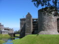 Rothesay Castle, Bute, with the 16th century forework in the centre, and the 13th century "Pigeon Tower" on the right
 -
 Brodick Castle, Arran
 -
 Kilmory Castle is incorporated into Meikle Kilmory Farm, Bute
 -
 Machrie Moor Stone Circle, Arran
 -
 Isle of Arran
 -
 Blaeu Atlas. Arania
 -
 Blaeu Atlas. Buthe Insula
 -
 Shire of Bute. by H. Moll
 -
 Kerrycroy Bay, Bute
 -
 Ardbeg, Bute
 -
 Lighthouse on Holy Island
 -
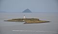 The isle of Pladda as seen from Arran, with Ailsa Craig in the distance
 -
 Machrie Moor Standing Stones on Arran
 -
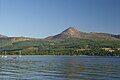 Goat Fell on Arran, the highest point of Buteshire


See also
References
- ^ Chisholm, Hugh, ed. (1911), , Encyclopædia Britannica, vol. 4 (11th ed.), Cambridge University Press, p. 879
- ^ "Land Register Counties", Leaflets, Registers of Scotland, archived from the original on 2 February 2010
- ^ Chalmers, George (1894). Caledonia. Paisley: Alexander Gardner. p. 28. Retrieved 26 February 2023.
- ^ Sheriffs (Scotland) Act 1747 (21 Geo. 2. c. 19), section 12. 1748. p. 108. Retrieved 26 February 2023.
- ^ Brown, Keith. "Act of the convention of estates of the kingdom of Scotland etc. for a new and voluntary offer to his majesty of £72,000 monthly for the space of twelve months, 23 January 1667". Records of the Parliament of Scotland. University of St Andrews. Retrieved 25 February 2023.
- ^ Historic Environment Scotland. "Town Hall And Sheriff Court, Castle Street, Rothesay, Bute (LB40453)". Retrieved 18 July 2021.
- ^ "Local Government (Scotland) Act 1973", legislation.gov.uk, The National Archives, 1973 c. 65, retrieved 26 February 2023
- ^ "Local Government etc. (Scotland) Act 1994", legislation.gov.uk, The National Archives, 1994 c. 39, retrieved 26 February 2023
- ^ "Land Mass Coverage Report" (PDF). Registers of Scotland. Archived from the original (PDF) on 3 March 2016. Retrieved 16 May 2015.
- ^ The National Cyclopaedia of Useful Knowledge, Vol.III, London, Charles Knight, 1847, p.967
- ^ "The Parliamentary Constituencies (Scotland) Order 2005", legislation.gov.uk, The National Archives, SI 2005/250
- ^ "County Bute: List of towns and places", Registers of Scotland, Land Register, 2000, archived from the original on 6 October 2002
External links
- Hedderwick, Robert (1878), , Encyclopædia Britannica, vol. 4 (9th ed.), pp. 579–581
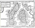
- NLS map of Buteshire. John Thompson's Atlas of Scotland. 1832.
| International | |
|---|---|
| National | |