
Buren
Buren | |
|---|---|
 Buren | |
 Flag  Coat of arms | |
.svg) Location in Gelderland | |
| Coordinates: 51°54′38″N 5°20′02″E / 51.91056°N 5.33389°E | |
| Country | Netherlands |
| Province | Gelderland |
| Government | |
| • Body | Municipal council |
| • Mayor | Jan de Boer (D66) |
| Area | |
| • Total | 142.92 km2 (55.18 sq mi) |
| • Land | 133.89 km2 (51.70 sq mi) |
| • Water | 9.03 km2 (3.49 sq mi) |
| Elevation | 5 m (16 ft) |
| Population (January 2021)[4] | |
| • Total | 27,009 |
| • Density | 202/km2 (520/sq mi) |
| Time zone | UTC+1 (CET) |
| • Summer (DST) | UTC+2 (CEST) |
| Postcode | Parts of 4000 and 4100 ranges |
| Area code | 0344, 0345 |
| Website | www |

Buren (Dutch pronunciation: [ˈbyːrə(n)] ) is a town and municipality in the Betuwe region of the Netherlands. Buren has 27,168 inhabitants as of 1 January 2022.
Geography
Buren is located in Gelderland, a province of the Netherlands. It is part of the landscape of Betuwe, a very fertile strip of land between two branches of Rhine-Meuse Delta, the Nederrijn in the north and the Waal in the south.
Population centers
Population centers include:
History
The earliest known settlement of the region occurred as early as 772.[5] Castle Buren was built by the Lords of Buren and was first mentioned in 1298. The town was granted city rights in 1395 by Sir Alard IV of Buren which led to the construction of a defensive wall and a moat, significant portions of which still stand. In 1492, the region was promoted to a county (i.e. a territory ruled by a count), but had limited economic influence due to its geographic isolation. By 1574, the previously Catholic parish church of Saint-Lambert (Dutch: Sint Lambertus) had become Calvinist Reformed Protestant.[citation needed]
_-_A_winter_landscape_with_activities_on_the_ice_near_Castle_Buren.jpg)
The Castle eventually came into the possession of the House of Orange, the royal family of the Netherlands. The Dutch royal family has been known to use the name van Buren as an alias to give themselves some degree of anonymity. William III of England obtained the title Buren. The Dutch royal family still use this as a title. The Castle was gradually demolished between 1804 and 1883. The eighth president of the United States, Martin Van Buren, traced his ancestry to inhabitants of the town, who had taken the surname Van Buren after relocating to the Dutch colony of New Netherlands in what is now the state of New York.[citation needed] In 1853, following the end of his presidency, Van Buren made a visit to the town while on a tour of Europe and reportedly met with several distant relatives.
The current municipality is the result of 2 mergers. On 1 January 1978, the municipalities of Beusichem, Zoelen and part of Buurmalsen were added to the existing municipality of Buren, that was formed in the mid-19th century. On 1 January 1999, Buren was enlarged with the addition of the municipalities of Lienden and Maurik.

Historical sites
Buren has two museums:
- The Museum of the Royal Military Police, located in a 17th-century orphanage.[6]
- The Museum of the Dutch Royal Family, located in the historic city hall.[7]
It is also home to De Prins Van Oranje, a restored windmill.
Government and politics
The title "Count or Countess of Buren and Leerdam" is held by the Dutch monarchy due to Prince William of Orange's marriage to the Countess of Buren, Anna of Egmont, in 1551. As a result, the county and the town of Buren fall under the control of the Royal House of Orange-Nassau.
Demographics
Twin town
Buren is twinned with:
Notable people
- Philip William, Prince of Orange (1554 in Buren – 1618) Prince of Orange in 1584 and Knight of the Golden Fleece in 1599
- Gerard de Kruijff (1890 in Buren – 1968) a Dutch horse rider who competed in the 1924 and the 1928 Summer Olympics
- Lukas Smits (born 1935 in Ravenswaaij) a Dutch painter.
- Jos Beijnen (born 1956 in Beusichem) a Dutch pharmacist and academic
- Ron Stevens (born 1959 in Lienden) a Dutch sprint canoer who competed in two Summer Olympics
Gallery
-
 The Culemborg gate with the Saint-Lambertus church, Buren in the background.
 -
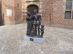 Statue in the center of Buren - William of Orange and Anna van Buren
 -
 Buren, panoramio
 -
 Buren, Herenstraat and the Rodeheldenstraat in the background.
 -
 Weighing scales and village pump on the market square in Buren.
 -
 Buren, church, de Sint-Lambertuskerk behind the wall
 -
 Buren, orphan house behind the wall


.jpg)

.jpg)


See also
References
- ^ "Samenstelling college" [Members of the board] (in Dutch). Gemeente Buren. Archived from the original on 14 July 2014. Retrieved 18 June 2014.
- ^ "Kerncijfers wijken en buurten 2020" [Key figures for neighbourhoods 2020]. StatLine (in Dutch). CBS. 24 July 2020. Retrieved 19 September 2020.
- ^ "Postcodetool for 4021VZ". Actueel Hoogtebestand Nederland (in Dutch). Het Waterschapshuis. Retrieved 18 June 2014.
- ^ "Bevolkingsontwikkeling; regio per maand" [Population growth; regions per month]. CBS Statline (in Dutch). CBS. 1 January 2021. Retrieved 2 January 2022.
- ^ Stenvert, R. et al. (2000). Monumenten in Nederland: Gelderland, p. 124–127. Zwolle: Waanders Uitgevers. ISBN 90-400-9406-3
- ^ "Home - Marechausseemuseum". Marechausseemuseum.nl. Archived from the original on 13 November 2014. Retrieved 15 January 2017.
- ^ "Burenenoranje". burenenoranje.nl. Archived from the original on 18 February 2009. Retrieved 15 January 2017.
- ^ "Zorgatlas". www.zorgatlas.nl. Archived from the original on 5 December 2011. Retrieved 15 January 2017.
- ^ "Kinderhook to honor sister city". Times Union. Albany, N.Y.: Hearst Newspapers. July 21, 2018. Retrieved August 5, 2018.
External links
Places adjacent to Buren | |
|---|---|

| International | |
|---|---|
| National | |
| Geographic | |