
Zuidas
Zuidas | |
|---|---|
Neighborhood of Amsterdam | |
 | |
 | |
| Coordinates: 52°20′20″N 4°52′24″E / 52.33889°N 4.87333°E | |
| Country | Netherlands |
| Province | North Holland |
| Municipality | Amsterdam |
| Borough | Amsterdam-Zuid |
| Area | |
| • Total | 0.95 sq mi (2.45 km2) |
| Population | |
| • Total | 2,805 |
| • Density | 3,000/sq mi (1,100/km2) |
| Time zone | CET (UTC+01) |
| Area code | 020 |
The Zuidas (literally South Axis in Dutch) is a rapidly developing business district in the city of Amsterdam in the Netherlands.[1] The Zuidas is also known as the 'Financial Mile'.[2] It lies between the rivers Amstel and Schinkel along the ringway A10. The greatest influences for the development of the Zuidas are La Défense in Paris and Canary Wharf in London. In size it can best be compared with the Noordruimte/Espace Nord in Brussels.
In the future, the local Amsterdam Zuid railway station is planned to become the second main station in Amsterdam.[3] It is expected to become the fifth busiest passenger station in the Netherlands, with connections to Schiphol Airport, Rotterdam, Antwerp, Brussels, and Paris via the Thalys, a high-speed rail. It will also connect to the German high-speed network, the ICE, via Utrecht and Arnhem.
The journey from the Zuidas to Amsterdam Airport Schiphol takes approximately 8 minutes.[4] Future development could include an underground line directly to the airport. Another high-speed link has been proposed by a consortium of companies between Amsterdam Airport Schiphol, Amsterdam Zuid and the city of Almere.
The Zuidas already has good underground connections to other business areas with the Circle Line. With the completion of the North South line, the Zuidas has an even better connection to the city center. The city council is not only investigating expanding the underground network to Amsterdam Airport Schiphol but also upgrading the hybrid metro/light rail line that stops at Amsterdam Zuid.[5]
Large multinationals such as ABN-Amro and Akzo Nobel have their headquarters in this new area. After Brexit, European Medicines Agency moved from London to Zuidas.[6][7][8]
Between 1998 and 2004, the World Trade Center Amsterdam was renovated[9] and expanded.[10] In 2005, floor space in Zuidas amounted to 3,000,000 square metres (32,000,000 sq ft).[11] Rapid expansion of Zuidas continued after 2005.[12]
The main infrastructural axis (Ring-A10) is scheduled to be tunnelled, transforming the entire area. This would add an estimated €2 billion to the cost of the plan.
Gallery
-
 District from above
 -
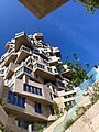
![ING House, nicknamed The Shoe[13]](//upload.wikimedia.org/wikipedia/commons/thumb/a/a0/Lexence_Building_%28208568017%29.jpeg/120px-Lexence_Building_%28208568017%29.jpeg)
-
 Valley mixed-use complex
 -

-
 Viñoly Tower
 -
 Headquarters of ABN Amro
 -
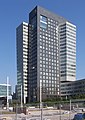
![Amsterdam Symphony [nl] building](//upload.wikimedia.org/wikipedia/commons/thumb/d/db/Amsterdam_Symphony_Towers.jpg/80px-Amsterdam_Symphony_Towers.jpg) Amsterdam Symphony building
Amsterdam Symphony building -
 High-rise Buildings around Gustav Mahlerlaan in 2021
 -
 Vivaldi building (European Medicines Agency)
 -
 Hourglass building

![ING House, nicknamed The Shoe[13]](/File:Lexence_Building_(208568017).jpeg)


.jpg)

![Amsterdam Symphony [nl] building](/File:Amsterdam_Symphony_Towers.jpg)


See also
- Law firms of the Netherlands
- "Zuidas Bibliotheek", hundreds of reports and documents about Zuidas
References
- ^ "Amsterdam Zuidas". Amsterdam Sights and Attractions. Retrieved 2024-01-13.
- ^ Wattel, Froukje (2020-08-28). "Walking a Financial Mile (and beyond)". MUSEUMCLUB.NL (in Dutch). Retrieved 2024-01-13.
- ^ "Amsterdam's Zuidas project criticised over possible disruptions". World Highways. 2015-04-27. Retrieved 2024-01-13.
- ^ "Amsterdam Zuidas". Amsterdam Sights and Attractions. Retrieved 2024-01-13.
- ^ "Transforming Zuidas financial district into bustrling urban hub". Arup. 2016-01-04. Retrieved 2024-01-13.
- ^ "EMA now operating from Amsterdam". European Medicines Agency. 2019-03-11. Retrieved 2024-01-13.
- ^ Wallskär, Helene (2020-01-28). "EMA fyller 25 år mitt i flyttbestyr och personaljakt". LäkemedelsVärlden. Retrieved 2024-01-13.
- ^ "EU flags are up in EMA's new building in Amsterdam". European Medicines Agency. 2020-02-03. Retrieved 2024-01-13.
- ^ Valkering, Michael. "Strik Attorneys at Law and Tax Advisors". www.strik-law.nl. Retrieved 2017-06-12.
- ^ "WTC Amsterdam Renovation - PLP Architecture". www.plparchitecture.com. Retrieved 2017-06-12.
- ^ "Amsterdam's Zuidas: A New Urban Landscape (CTBUH Research Paper)" (PDF). Archived from the original (PDF) on 2024-01-13. Retrieved 2024-01-13.
- ^ "Zuidas Monitor. A bi-annual office market analysis of the Zuidas district (2016)". Archived from the original on 2024-01-13. Retrieved 2024-01-13.
- ^ ING Building, Meyer & Van Schooten Architecten
External links
- Zuidas, website of the city of Amsterdam