
Warnsveld
Warnsveld | |
|---|---|
Town | |
 Church of Warnsveld | |
 Flag  Coat of arms | |
 Warnsveld Location in the province of Gelderland in the Netherlands  Warnsveld Warnsveld (Netherlands) | |
| Coordinates: 52°8′30″N 6°13′18″E / 52.14167°N 6.22167°E | |
| Country | Netherlands |
| Province | Gelderland |
| Municipality | Zutphen |
| Area | |
| • Total | 15.53 km2 (6.00 sq mi) |
| Elevation | 9 m (30 ft) |
| Population (2021)[1] | |
| • Total | 8,390 |
| • Density | 540/km2 (1,400/sq mi) |
| Time zone | UTC+1 (CET) |
| • Summer (DST) | UTC+2 (CEST) |
| Postal code | 7230-7232[1] |
| Dialing code | 0575 |
Warnsveld is a town in the eastern Netherlands, about 2 km east of Zutphen.
History
The first mention of the village in writing is from the year 1121 as Wansveld, and means "field of Warin or Warni (person)".[3] Warnsveld developed in the Middle Ages along the Berkel.[4]
Warnsveld's Martinuskerk (Church of Saint Martin) has a tower from around 1100. In the 15th century, both the church and tower were enlarged. The church was restored between 1954 and 1957, and the 19th century modifications were undone.[4]
The former havezate 't Velde was first mentioned in 1326. Shortly after 1535 it redesigned in early Renaissance style. It was extensively modified and enlarged in 1701.[4] It is nowadays used by the police academy.[5]
Warnsveld was home to 505 people in 1840.[5] In 1841, the road between Zutphen and Lochem was paved, and estates were built along the road.[4]
Warnsveld was a separate municipality until 2005, when it was merged with Zutphen.[6] The former municipality had a population of about 9,000, and covered both the village of Warnsveld and nearby Warken.
People born in Warnsveld
- Richard Constant Boer (1863-1929), linguist
- Gert Holstege (born 1948), neuroscientist
- Ellen ten Damme (born 1967), singer & actor
- Anne-Wil Lucas-Smeerdijk (born 1975), politician
- Jan Werle (born 1984), chess player Grandmaster
- Thijs van Amerongen (born 1986), cyclo-cross cyclist
People died in Warnsveld
- Ida Gerhardt (1905-1997), poet
- Philip Kouwen (1922-2002), artist
Gallery
-
 Windmill: korenmolen Nooit Gedacht
 -
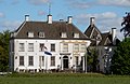 Country house Huis' t Velde (nowadays a police academy)
 -
 Villa in Warnsveld
 -
 Gate house

_RM526688_IMG_5265_2020-05-05_11.54.jpg)
_-_Rijksstraatweg_113.JPG)

References
- ^ a b c "Kerncijfers wijken en buurten 2021". Central Bureau of Statistics. Retrieved 14 April 2022.
- ^ "Postcodetool for 7231AA". Actueel Hoogtebestand Nederland (in Dutch). Het Waterschapshuis. Retrieved 14 April 2022.
- ^ "Warnsveld - (geografische naam)". Etymologiebank (in Dutch). Retrieved 14 April 2022.
- ^ a b c d Ronald Stenvert & Sabine Broekhoven (2000). "Warnsveld" (in Dutch). Zwolle: Waanders. ISBN 90 400 9406 3. Retrieved 14 April 2022.
- ^ a b "Warnsveld". Plaatsengids (in Dutch). Retrieved 14 April 2022.
- ^ Ad van der Meer and Onno Boonstra, Repertorium van Nederlandse gemeenten, KNAW, 2011.