
Voľa

Voľa (Hungarian: Laborcfalva) is a village and municipality in Michalovce District in the Kosice Region of eastern Slovakia.
History
In historical records the village was first mentioned in 1357.
Geography
The village lies at an altitude of 127 metres and covers an area of 5.782 km². The municipality has a population of about 250 people.
Voľa neighbours Nacina Ves to the south and the town of Strážske to the north. To the west of the main village lies the small hamlet of Vybuchanec, the only other settled place in the Voľa municipality.
Transport
Voľa lies on the main road and near the main railway line between Michalovce and Humenné.
The village is serviced by regular bus lines on the main road. The nearest large train station is in Strážske and a smaller one in Nacina Ves.
Gallery
-
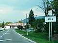 Entering the village of Voľa
 -
 Older houses in Voľa
 -
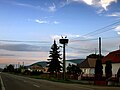
 The street in Voľa during daytime (May 2019)
 -
 The street in Voľa during the evening hours (August 2008)
 -
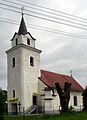 Greek Catholic church in Voľa
 -
 Greek Catholic church in Voľa
 -
 White storks nesting in Voľa
 -
 White storks nesting in Voľa
 -
 White storks nesting in Voľa
 -
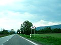 Leaving the village of Voľa


External links
48°51′N 21°51′E / 48.850°N 21.850°E
This Michalovce District geography article is a stub. You can help Wikipedia by expanding it. |