Source: Wikipedia, the free encyclopedia.
-
Ethnic groups and their territories in Cameroon's Adamawa Province
-
The same map without the labels
-
Ethnic groups and their territories in Cameroon's Centre Province
-
The same map without the labels
-
Ethnic groups and their territories in Cameroon's East Province
-
The same map without the labels
-
Cameroon's Extreme North Province with territories of its ethnic groups indicated
-
The same map without the labels
-
Ethnic groups and their territories in Cameroon's North Province
-
The same map without the labels
-
Cameroon's South Province with territories of its ethnic groups indicated
-
The same map without the labels
-
Ethnic groups and their territories in Cameroon's West Province
-
The same map without the labels
-
Map showing the Duala ethnic groups of Cameroon
-
The same map with no labels
-
Map showing the Maka-Njem ethnic groups of Cameroon, CAR, Gabon, and Equatorial Guinea
-
The same map with no labels


 Ethnic groups and their territories in Cameroon's Adamawa Province
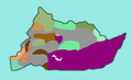 The same map without the labels
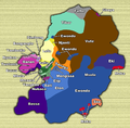 Ethnic groups and their territories in Cameroon's Centre Province
 The same map without the labels
 Ethnic groups and their territories in Cameroon's East Province
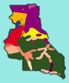 The same map without the labels
 Cameroon's Extreme North Province with territories of its ethnic groups indicated
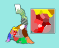 The same map without the labels
 Ethnic groups and their territories in Cameroon's North Province
 The same map without the labels
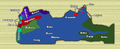 Cameroon's South Province with territories of its ethnic groups indicated
 The same map without the labels
 Ethnic groups and their territories in Cameroon's West Province
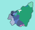 The same map without the labels
 Map showing the Duala ethnic groups of Cameroon
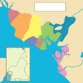 The same map with no labels
 Map showing the Maka-Njem ethnic groups of Cameroon, CAR, Gabon, and Equatorial Guinea
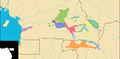 The same map with no labels
.png)

.png)

.png)

.png)

.png)

.png)

.png)

.png)