
Upper Greenock railway station
Upper Greenock | |
|---|---|
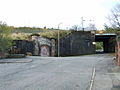
 The bricked-up entrance to the old Upper Greenock station. | |
| General information | |
| Location | Greenock, Inverclyde Scotland |
| Coordinates | 55°56′24″N 4°45′29″W / 55.940°N 4.758°W |
| Platforms | 2 |
| Other information | |
| Status | Disused |
| History | |
| Original company | Greenock and Wemyss Bay Railway |
| Pre-grouping | Caledonian Railway |
| Post-grouping | LMS |
| Key dates | |
| 15 May 1865 | Opened[1] |
| 5 June 1967 | Closed |
Upper Greenock railway station was a railway station serving the town of Greenock, Inverclyde, Scotland, originally as part of the Greenock and Wemyss Bay Railway and later owned by the Caledonian Railway.
History
The station opened on 15 May 1865 and closed permanently on 5 June 1967. The station was directly replaced by Branchton station, approximately 2.8 km west.
Gallery
-
 The station was located at the top of Lynedoch Street
 -
 The bricked-up entrance on Lynedoch Street


| Preceding station | Historical railways | Following station | ||
|---|---|---|---|---|
| Ravenscraig Line open; station closed |
Caledonian Railway Greenock and Wemyss Bay Railway |
Port Glasgow Line and station open | ||
References
Notes
- ^ Butt (1995)
Sources
- Butt, R. V. J. (October 1995). The Directory of Railway Stations: details every public and private passenger station, halt, platform and stopping place, past and present (1st ed.). Sparkford: Patrick Stephens Ltd. ISBN 978-1-85260-508-7. OCLC 60251199. OL 11956311M.
- Jowett, Alan (March 1989). Jowett's Railway Atlas of Great Britain and Ireland: From Pre-Grouping to the Present Day (1st ed.). Sparkford: Patrick Stephens Ltd. ISBN 978-1-85260-086-0. OCLC 22311137.
- Jowett, Alan (2000). Jowett's Nationalised Railway Atlas (1st ed.). Penryn, Cornwall: Atlantic Transport Publishers. ISBN 978-0-906899-99-1. OCLC 228266687.
This Scotland railway station-related article is a stub. You can help Wikipedia by expanding it. |