
St. Andrews State Park
| Saint Andrews State Park | |
|---|---|
IUCN category IV (habitat/species management area) | |
 | |
  | |
| Location | Bay County, Florida, USA |
| Nearest city | Panama City Beach, Florida |
| Coordinates | 30°08′05″N 85°44′38″W / 30.134632°N 85.743964°W |
| Area | 1,200 acres (4.9 km2) |
| Visitors | 750,000 (in 2005) |
| Governing body | Florida Department of Environmental Protection |
Wikimedia Commons has media related to St. Andrews State Park.
St. Andrews State Park is a 1,200-acre (4.9 km2) Florida State Park located three miles (5 km) east of Panama City Beach Florida, off U.S. 98. It is the headquarters of one of the state's five AmeriCorps Florida State Parks chapters.
Recreational activities
The park has such amenities as two-and-a-half miles of beaches, bicycling, birding, boat tours, boating, canoeing, two fishing piers, hiking, kayaking, picnicking areas, scuba diving, snorkeling, swimming, wildlife viewing and full camping facilities. During the summer, camping reservations are recommended for best availability. It also has a visitor center, an interpretive exhibit and concessions.
Gallery
-
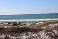
 Beach on the Gulf of Mexico, in the park
 -
 Emerald Coast waters in the park
 -
 White sand dunes


External links
This Florida State Park related article is a stub. You can help Wikipedia by expanding it. |