Metropolitan Borough of Bury: Difference between revisions
style=margin-left:10px |
→Parliamentary Constituencies: adding sale of lowery |
||
| Line 42: | Line 42: | ||
The metropolitan borough came into existence on [[April 1]], [[1974]], with the transfer of functions from the [[county borough]] of Bury and the boroughs of [[Prestwich]] and [[Radcliffe, Greater Manchester|Radcliffe]], along with the urban districts of [[Tottington, Greater Manchester|Tottington]] and [[Whitefield, Greater Manchester|Whitefield]], and part of the urban district of [[Ramsbottom]]. |
The metropolitan borough came into existence on [[April 1]], [[1974]], with the transfer of functions from the [[county borough]] of Bury and the boroughs of [[Prestwich]] and [[Radcliffe, Greater Manchester|Radcliffe]], along with the urban districts of [[Tottington, Greater Manchester|Tottington]] and [[Whitefield, Greater Manchester|Whitefield]], and part of the urban district of [[Ramsbottom]]. |
||
==Sale of Lowery painting== |
|||
In [[2006]], facing a budget shortfall of over £10 million, the council decided to sell its painting by [[LS Lowery]] called ''"A Riverbank"''. The work - depicting the [[River Irwell]] - cost £175 in [[1951]] and was expected to fetch between £500,000 and £800,000. |
|||
Between the announcement and the sale at [[Christie's]], the council was accused of ''"selling off the family silver"''. The authority, which had the painting on display at [[Bury Museum and Art Gallery]], said it was putting its people before a picture. |
|||
The painting raised £1.25 million for the authority on [[17 November]], [[2006]] at the auction in [[London]], costing the bidder £1,408.000 including commission<ref>http://news.bbc.co.uk/1/hi/england/manchester/6157204.stm</ref>. |
|||
==Parliamentary Constituencies== |
==Parliamentary Constituencies== |
||
Revision as of 20:21, 17 November 2006
| Borough of Bury | |
|---|---|

| |
| Geography | |
| Status: | Metropolitan borough |
| Region: | North West England |
| Ceremonial County: | Greater Manchester |
| Historic County: | Lancashire |
| Area: - Total |
Ranked 244th 99.48 km² |
| Admin. HQ: | Bury |
| ONS code: | 00BM |
| Demographics | |
| Population: - Total (2022) - Density |
Ranked / km² |
| Ethnicity: | 93.9% White 4.0% S.Asian |
| Politics | |
| Arms of Bury Metropolitan Borough Council Bury Metropolitan Borough Council http://www.bury.gov.uk/ | |
| Leadership: | Leader & Cabinet |
| Executive: | |
| MPs: | David Chaytor, Ivan Lewis |
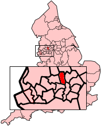
The Metropolitan borough of Bury is a metropolitan borough in northern Greater Manchester. The borough consists of six towns: Bury, Ramsbottom, Tottington, Radcliffe, Whitefield and Prestwich.
The borough has an area of 24,511 acres and serves a population of 181,900.
The metropolitan borough came into existence on April 1, 1974, with the transfer of functions from the county borough of Bury and the boroughs of Prestwich and Radcliffe, along with the urban districts of Tottington and Whitefield, and part of the urban district of Ramsbottom.
Sale of Lowery painting
In 2006, facing a budget shortfall of over £10 million, the council decided to sell its painting by LS Lowery called "A Riverbank". The work - depicting the River Irwell - cost £175 in 1951 and was expected to fetch between £500,000 and £800,000.
Between the announcement and the sale at Christie's, the council was accused of "selling off the family silver". The authority, which had the painting on display at Bury Museum and Art Gallery, said it was putting its people before a picture.
The painting raised £1.25 million for the authority on 17 November, 2006 at the auction in London, costing the bidder £1,408.000 including commission[1].
Parliamentary Constituencies
The Metropolitan Borough of Bury currently consists of two parliamentary constituencies:
Twin Towns
- China
- France
- Angoulême, Charente département
- Tulle, Corrèze département
- Germany
- USA
Unparished Areas
Showing former status (prior to 1974)
The entirety of the borough is unparished.
- Bury (County Borough)
- Prestwich (Municipal Borough)
- Radcliffe (Municipal Borough)
- Ramsbottom (Urban District) (part)
- Tottington (Urban District)
- Whitefield (Urban District)

