
Rhine-Taunus Nature Park

The Rhine Taunus Nature Park (German: Naturpark Rhein-Taunus), located in the Rheingau-Taunus-Kreis and Wiesbaden district of Hesse, Germany was founded in 1968. It includes the western part of the Taunus and extends over the Idsteiner Becken to the Rhine. It is characterized by a roughly 60 percent forested low mountain landscape, which falls away steeply toward the Rhine Gorge.
-
 Erlenbachtal near Wiesbaden-Frauenstein
 -
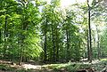 Honigberg near Kiedrich
 -
 Highest point of the Rheingau-Taunus-Kreis: 629,3 m high mountain Windhain near Waldems
 -
 View from Windhain mountain over Waldems' constituent communities Niederems and Reinborn
 -
 Viewpoint Isberg-Tempelchen above Niederems


External links
Wikimedia Commons has media related to Naturpark Rhein-Taunus.
- Official website (German only)
 | ||
| International | |
|---|---|
| National | |
50°07′48″N 8°09′36″E / 50.13000°N 8.16000°E
This Hesse location article is a stub. You can help Wikipedia by expanding it. |
This article related to a protected area in Europe is a stub. You can help Wikipedia by expanding it. |