
Pusztaszabolcs
This article needs additional citations for verification. (September 2022) |
Pusztaszabolcs | |
|---|---|
 Aerial view | |
 Coat of arms | |
 Location of Fejér county in Hungary | |
 Pusztaszabolcs Location of Pusztaszabolcs | |
| Coordinates: 47°08′29″N 18°45′34″E / 47.14127°N 18.75940°E | |
| Country | |
| County | Fejér |
| District | Dunaújváros |
| Area | |
| • Total | 51.67 km2 (19.95 sq mi) |
| Population (2015) | |
| • Total | 5,904[1] |
| Time zone | UTC+1 (CET) |
| • Summer (DST) | UTC+2 (CEST) |
| Postal code | 2490 |
| Area code | (+36) 25 |
| Website | www |
Pusztaszabolcs is a town in Fejér County, Hungary.
Sights
- Reformed church
- Roman Catholic church
- MÁV 375 series steam locomotive
Twin towns – sister cities
Pusztaszabolcs is twinned with:
 Staufenberg, Germany
 Dorobanți, Romania
Gallery
-
 First World War monument
 -
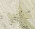 Map of Pusztaszabolcs from the First Military Mapping Survey of the Austrian Empire.
 -
 Map of Pusztaszabolcs from the Second Military Mapping Survey of the Austrian Empire.
 -
 Map of Pusztaszabolcs from the Third Military Mapping Survey of the Austrian Empire.
.jpg)


References
- ^ Gazetteer of Hungary, 1 January 2015. Hungarian Central Statistical Office.
External links
Wikimedia Commons has media related to Pusztaszabolcs.
- Official website in Hungarian
- Street map (in Hungarian)
| City with county rights (1) |
| |
|---|---|---|
| Towns (3) | ||
| Large villages (3) | ||
| Villages (9) | ||


This Fejér location article is a stub. You can help Wikipedia by expanding it. |