
Puente Genil
Puente Genil | |
|---|---|
 | |
 Coat of arms | |
 Puente Genil Location in Spain | |
| Coordinates: 37°23′0″N 4°46′0″W / 37.38333°N 4.76667°W | |
| Country | |
| Autonomous community | |
| Province | Córdoba |
| Comarca | Campiña Sur |
| Judicial district | Puente Genil |
| • Alcalde | (IU) |
| Area | |
| • Total | 171.05 km2 (66.04 sq mi) |
| Elevation | 217 m (712 ft) |
| Population (2018)[1] | |
| • Total | 30,241 |
| • Density | 180/km2 (460/sq mi) |
| Demonym(s) | Pontanés/a, pontano/a, pontanense |
| Time zone | UTC+1 (CET) |
| • Summer (DST) | UTC+2 (CEST) |
| Postal code | 14500 |
| Official language(s) | Spanish |
| Website | Official website |
Puente Genil (Spanish pronunciation: [ˈpwente xeˈnil]) is a Spanish city in the province of Córdoba, autonomous community of Andalusia. It is situated about 45 miles (70 km) from the provincial capital, Córdoba. It has a population of around 30,000 people.
Etymology
The name of the town comes from the bridge over the river Genil.
Description
The town is an agricultural centre, also known for its Semana Santa celebration, contracted in the local vernacular to "mananta".
-
 Parish church of La Purificación
 -
 Mosaic of the Three Graces
 -
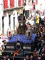 Religious procession
 -
 An aerial view of the town and surrounding countryside
 -
![Laguna de Tíscar, a Ramsar site located in the Puente Genil municipality[2]](//upload.wikimedia.org/wikipedia/commons/thumb/9/91/Laguna_de_tiscar.PNG/120px-Laguna_de_tiscar.PNG)


![Laguna de Tíscar, a Ramsar site located in the Puente Genil municipality[2]](/File:Laguna_de_tiscar.PNG)
Transport
Puente Genil is served by Puente Genil-Herrera railway station, around 4 km from the town centre on the AVE high-speed rail line from Madrid to Málaga.
References
- ^ Municipal Register of Spain 2018. National Statistics Institute.
- ^ Laguna de Tiscar - Ayuntamiento de Puente Genil
External links
 Media related to Puente Genil at Wikimedia Commons
- Chisholm, Hugh, ed. (1911). . Encyclopædia Britannica. Vol. 22 (11th ed.). Cambridge University Press. p. 634.
| International | |
|---|---|
| National | |
| Geographic | |
This article about a location in Andalusia, Spain, is a stub. You can help Wikipedia by expanding it. |