×
Close
×
Close
Main menu
Main menu
move to sidebar
hide
Navigation
Main page
Contents
Current events
Random article
About Wikipedia
Contact us
Donate
Contribute
Help
Learn to edit
Community portal
Recent changes
Upload file
Search
Search
Appearance
Create account
Log in
Personal tools
Create account
Log in
Pages for logged out editors
learn more
Contributions
Talk
Portal
:
Maps/Maps/Nautical/2
Add languages
Add links
Portal
Talk
English
Read
Edit
View history
Tools
Tools
move to sidebar
hide
Actions
Read
Edit
View history
General
What links here
Related changes
Upload file
Special pages
Permanent link
Page information
Get shortened URL
Download QR code
Print/export
Download as PDF
Printable version
Appearance
move to sidebar
hide
Source: Wikipedia, the free encyclopedia.
<
Portal:Maps
|
Maps
|
Nautical
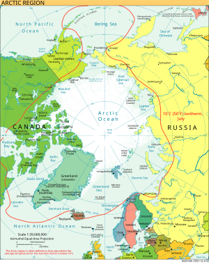
The Arctic region border
Credit:
CIA World Factbook
A map of the
Arctic
, the red line indicates the 10°C
isotherm
in July, commonly used to define the Arctic region border.
 The Arctic region border


