
Portal:Guatemala
The Guatemala portal
Republic of Guatemala República de Guatemala (Spanish) | |
|---|---|
Motto:
| |
| Anthem: Himno Nacional de Guatemala (English: "National Anthem of Guatemala") | |
| ISO 3166 code | GT |


Guatemala, officially the Republic of Guatemala, is a country in Central America. It is bordered to the north and west by Mexico, to the northeast by Belize, to the east by Honduras, and to the southeast by El Salvador. It is hydrologically bordered to the south by the Pacific Ocean and to the northeast by the Gulf of Honduras.
The territory of modern Guatemala hosted the core of the Maya civilization, which extended across Mesoamerica; in the 16th century, most of this was conquered by the Spanish and claimed as part of the viceroyalty of New Spain. Guatemala attained independence from Spain and Mexico in 1821. From 1823 to 1841, it was part of the Federal Republic of Central America.
For the latter half of the 19th century, Guatemala suffered instability and civil strife. From the early 20th century, it was ruled by a series of dictators backed by the United States. In 1944, authoritarian leader Jorge Ubico was overthrown by a pro-democratic military coup, initiating a decade-long revolution that led to social and economic reforms. In 1954, a US-backed military coup ended the revolution and installed a dictatorship.
From 1960 to 1996, Guatemala endured a bloody civil war fought between the US-backed government and leftist rebels, including genocidal massacres of the Maya population perpetrated by the Guatemalan military. The United Nations negotiated a peace accord, resulting in economic growth and successive democratic elections.
Guatemala's abundance of biologically significant and unique ecosystems includes many endemic species and contributes to Mesoamerica's designation as a biodiversity hotspot.
Although rich in export goods, around a quarter of the population (4.6 million) face food insecurity. Other extant major issues include poverty, crime, corruption, drug trafficking, and civil instability.
With an estimated population of around 17.6 million,0 Guatemala is the most populous country in Central America, the 4th most populous country in North America and the 11th most populous country in the Americas. Its capital and largest city, Guatemala City, is the most populous city in Central America. (Full article...)
Selected article -

Miguel Ángel Asturias Rosales (Spanish: [mi(ˈ)ɣel ˈaŋxel asˈtuɾjas]; 19 October 1899 – 9 June 1974) was a Guatemalan poet-diplomat, novelist, playwright and journalist. Winning the Nobel Prize in Literature in 1967, his work helped bring attention to the importance of indigenous cultures, especially those of his native Guatemala.
Asturias was born and raised in Guatemala though he lived a significant part of his adult life abroad. He first lived in Paris in the 1920s where he studied ethnology. Some scholars view him as the first Latin American novelist to show how the study of anthropology and linguistics could affect the writing of literature. While in Paris, Asturias also associated with the Surrealist movement, and he is credited with introducing many features of modernist style into Latin American letters. In this way, he is an important precursor of the Latin American Boom of the 1960s and 1970s. (Full article...)
Did you know (auto-generated)

- ... that the Central American government voted for annexation to the First Mexican Empire after a request from Regent Agustín de Iturbide?
- ... that the Adelaide L. T. Douglas House, built for a New York City socialite, housed the United States Olympic Committee before being sold to Guatemala?
- ... that Miles Rock served as chief of the commission that determined the disputed Guatemala–Mexico border?
Subcategories
WikiProjects

 Good article -

Zaculeu or Saqulew is a pre-Columbian Maya archaeological site in the highlands of western Guatemala, about 3.7 kilometres (2.3 mi) outside the modern city of Huehuetenango. Occupation at the site dates to the Early Classic period (AD 250–600) of Mesoamerican history. Zaculeu was the capital of the Postclassic Mam kingdom, and was conquered by the Kʼicheʼ Kingdom of Qʼumarkaj. It displays a mixture of Mam and Kʼicheʼ style architecture.
In AD 1525 the city was attacked by Spanish conquistadors under Gonzalo de Alvarado y Contreras during a siege that lasted several months. Kayb'il B'alam, the city's last ruler, finally surrendered to the Spanish due to starvation. (Full article...)
Selected image -
-
 A low impact trail built for ecotourists to protect an archeological site in Guatemala
 -
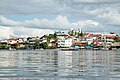 A view of Flores, El Petén
 -

-

-
 A camioneta or chicken bus, a typical mode of transportation in Guatemala
 -
 Lake Atitlán, from a dock in San Juan La Laguna
 -
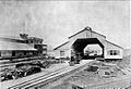 Station and Customs of Puerto Barrios, Guatemala, Northern Railway, 1896
 -
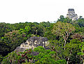 View from the top of the Lost World Pyramid, Temple IV on the right and top of pyramid 5C-49 (also known as the Talud-Tablero Temple) in the Plaza of the Lost World
 -
 A view of the beach in Livingston, Guatemala


_-_Guatemala-1525.jpg)

More did you know -
- Communist leader José Manuel Fortuny was a friend and adviser to Guatemalan President Jacobo Árbenz.
 Featured article -
.jpg)
In a protracted conflict during the Spanish colonization of the Americas, Spanish colonisers gradually incorporated the territory that became the modern country of Guatemala into the colonial Viceroyalty of New Spain. Before the conquest, this territory contained a number of competing Mesoamerican kingdoms, the majority of which were Maya. Many conquistadors viewed the Maya as "infidels" who needed to be forcefully converted and pacified, disregarding the achievements of their civilization. The first contact between the Maya and European explorers came in the early 16th century when a Spanish ship sailing from Panama to Santo Domingo (Hispaniola) was wrecked on the east coast of the Yucatán Peninsula in 1511. Several Spanish expeditions followed in 1517 and 1519, making landfall on various parts of the Yucatán coast. The Spanish conquest of the Maya was a prolonged affair; the Maya kingdoms resisted integration into the Spanish Empire with such tenacity that their defeat took almost two centuries.
Pedro de Alvarado arrived in Guatemala from the newly conquered Mexico in early 1524, commanding a mixed force of Spanish conquistadors and native allies, mostly from Tlaxcala and Cholula. Geographic features across Guatemala now bear Nahuatl placenames owing to the influence of these Mexican allies, who translated for the Spanish. The Kaqchikel Maya initially allied themselves with the Spanish, but soon rebelled against excessive demands for tribute and did not finally surrender until 1530. In the meantime the other major highland Maya kingdoms had each been defeated in turn by the Spanish and allied warriors from Mexico and already subjugated Maya kingdoms in Guatemala. The Itza Maya and other lowland groups in the Petén Basin were first contacted by Hernán Cortés in 1525, but remained independent and hostile to the encroaching Spanish until 1697, when a concerted Spanish assault led by Martín de Ursúa y Arizmendi finally defeated the last independent Maya kingdom. (Full article...)
List of Featured articles
|
|---|
General images -
The following are images from various Guatemala-related articles on Wikipedia.
-
 Day laborers receiving their pay in Santa Rosa, circa 1890, as per the Day Laborer Regulations established by Barrios (from History of Guatemala)
 -
 Map of Guatemala in 1829. Note that borders with Mexico, Yucatán, and Chiapas are not defined. (from History of Guatemala)
 -
 General Francisco Morazán (from History of Guatemala)
 -
 Coat of Arms of the Republic of Guatemala from 1858 to 1871. A replica was carved on the front of the Carrera Theater before it was remodeled in 1892. (from History of Guatemala)
 -
 Route map of the Great White Fleet of the United Fruit Company, which held a monopoly on freight and passenger maritime transport to and from Puerto Barrios in Guatemala since 1903. (from History of Guatemala)
 -
 Coat of arms of the state of Los Altos, carved in stone on the grave of heroes at the Cemetery of Quetzaltenango (from History of Guatemala)
 -
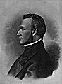
 Captain General Rafael Carrera after being appointed president for Life of the Republic of Guatemala in 1854 (from History of Guatemala)
 -
 Location of the Franja Transversal del Norte (Northern Transversal Strip) in Guatemala (from History of Guatemala)
 -
 Maya city of Tikal (from History of Guatemala)
 -
 Inauguration of Colonel Jacobo Árbenz as President of Guatemala, 1951. (from History of Guatemala)
 -
 General Carrera, portrait celebrating the foundation of the Republic of Guatemala in 1847 (from History of Guatemala)
 -
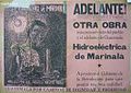 Advertisement for the Marinalá power plant during the Árbenz government (from History of Guatemala)
 -
 Central America in the 16th century, before the Spanish conquest (from History of Guatemala)
 -
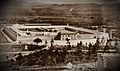 Guatemalan National Penitentiary, built by Barrios to incarcerate and torture his political enemies (from History of Guatemala)
 -
 Manuel Estrada Cabrera ruled Guatemala from 1898 to 1920. (from History of Guatemala)
 -
 General Manuel José Arce; decorated Salvadoran General and president of the Federal Republic of Central America from 1825 to 1829. (from History of Guatemala)
 -
 1861 map showing the boundary between British Honduras (now Belize) and Guatemala (from History of Guatemala)
 -
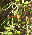 Chiltepe, a common pepper used on some Guatemalan dishes. (from Culture of Guatemala)
 -
 Criollos rejoice upon learning of the declaration of independence on 15 September 1821. Painting by Rafael Beltranena. (from History of Guatemala)
 -
 Map of railway lines in Guatemala and El Salvador, owned by the IRCA, a subsidiary of the United Fruit Company that controlled the railroads in both countries. The only Atlantic port was controlled by the Great White Fleet, also a UFCO company. (from History of Guatemala)
 -
 Barrigones sculpture (from History of Guatemala)
 -
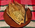 Chipilín Tamal, a common dish usually eaten at dinner. (from Culture of Guatemala)
 -
 Plaza Central of Antigua Guatemala in 1829. The old "Palacio de la Capitanía General" remained in ruins following the 1773 earthquake. (from History of Guatemala)
 -
 Guatemalan territory during the conservative regimes of Rafael Carrera and Vicente Cerna. The Soconusco territories were ceded to Mexico in exchange for support during the Liberal revolution of 1871, as stipulated by the Herrera-Mariscal Treaty of 1882. (from History of Guatemala)
 -
 The Jurun Marinalá power plant was conceived during the Árbenz government to compete with the Electricity Company of Guatemala, which was then an American company using foreign oil instead of Guatemala's natural resources. Construction of the plant was not completed until 1968, fourteen years after Árbenz was removed in a CIA-sponsored coup d'état in 1954. (from History of Guatemala)
 -
 Finance Center in 2011. In 1981, a powerful bomb exploded in the building's basement, leaving it without windows for several years. The owners, Industrial Bank, decided to keep the building open to the public as a defiant stance against the leftist guerrilla. (from History of Guatemala)
 -
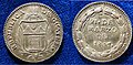 Proclamation coin from 1847 of the independent Republic of Guatemala (from History of Guatemala)


Topics
Ancestral background of Guatemalan citizens | |
| Guatemalan native groups (Maya and others) | |
| Former and extinct | |
| Guatemalan mestizo | |
| Descendants of Europeans (white or Criollo) | |
| Descendants of Asians | |
| Afro-descendants | |
| Americas | |
Featured articles
Good articles
- 5to Piso
- 2010 Guatemala City sinkhole
- Adentro
- Gómez de Alvarado
- El Amor (Ricardo Arjona song)
- Francisco Javier Arana
- Jacobo Árbenz
- Ricardo Arjona
- La Blanca, Peten
- Bartolomé de las Casas
- Central America under Mexican rule
- Como Duele (Ricardo Arjona song)
- El Chal
- Fuiste Tú
- Guatemala at the 2016 Summer Paralympics
- Guatemalan Revolution
- Haʼ Kʼin Xook
- Independiente (Ricardo Arjona album)
- Itzam Kʼan Ahk II
- Iximche
- Kʼinich Yat Ahk II
- Kʼinich Yoʼnal Ahk I
- Manche Chʼol
- Marta (Ricardo Arjona song)
- Mi Novia Se Me Está Poniendo Vieja
- Mixco Viejo
- Motul de San José
- Mundo Perdido, Tikal
- North Acropolis, Tikal
- Poquita Ropa
- Puente (song)
- Quién Dijo Ayer
- Quién (Ricardo Arjona song)
- Quiero (Ricardo Arjona song)
- Battle of Roatán
- Simplemente Lo Mejor
- Spanish American wars of independence
- Spanish conquest of Yucatán
- Spanish conquest of the Maya
- Te Quiero (Ricardo Arjona song)
- Tikal
- Trópico (Ricardo Arjona album)
- Vida (Ricardo Arjona song)
- White-lipped peccary
- Yoʼnal Ahk III
- Zaculeu
Featured pictures
-
 Cinnamon hummingbird (Amazilia rutila) in flight Los Tarrales
 -
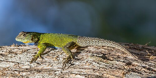 Emerald swift (Sceloporus malachiticus) Finca El Pilar
 -
 Ocellated turkey (Meleagris ocellata) male Peten
_in_flight_Los_Tarrales.jpg)
_Finca_El_Pilar.jpg)
_male_Peten.jpg)
Associated Wikimedia
The following Wikimedia Foundation sister projects provide more on this subject:
-
 Commons
Free media repository -
 Wikibooks
Free textbooks and manuals -
 Wikidata
Free knowledge base -
 Wikinews
Free-content news -
 Wikiquote
Collection of quotations -
 Wikisource
Free-content library -
 Wikiversity
Free learning tools -
 Wikivoyage
Free travel guide -
 Wiktionary
Dictionary and thesaurus
Guatemala news
The current date and time in Guatemala is Saturday, March 29, 2025, 20:09.
News media:
- The Guatemala Times
- La Prensa Libre (in Spanish)
- Wikinews Guatemala portal
Sources


