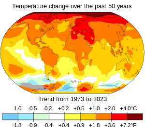
Geology describes the structure of the Earth on and beneath its surface and the processes that have shaped that structure. Geologists study the mineralogical composition of rocks in order to get insight into their history of formation. Geology determines the relative ages of rocks found at a given location; geochemistry (a branch of geology) determines their absolute ages. By combining various petrological, crystallographic, and paleontological tools, geologists are able to chronicle the geological history of the Earth as a whole. One aspect is to demonstrate the age of the Earth. Geology provides evidence for plate tectonics, the evolutionary history of life, and the Earth's past climates.
The geology of the Grand Canyon area includes one of the most complete and studied sequences of rock on Earth. The nearly 40 major sedimentary rock layers exposed in the Grand Canyon and in the Grand Canyon National Park area range in age from about 200 million to nearly 2 billion years old. Most were deposited in warm, shallow seas and near ancient, long-gone sea shores in western North America. Both marine and terrestrial sediments are represented, including lithified sand dunes from an extinct desert. There are at least 14 known unconformities in the geologic record found in the Grand Canyon.
Uplift of the region started about 75 million years ago during the Laramide orogeny; a mountain-building event that is largely responsible for creating the Rocky Mountains to the east. In total, the Colorado Plateau was uplifted an estimated 2 miles (3.2 km). The adjacent Basin and Range Province to the west started to form about 18 million years ago as the result of crustal stretching. A drainage system that flowed through what is today the eastern Grand Canyon emptied into the now lower Basin and Range province. The opening of the Gulf of California around 6 million years ago enabled a large river to cut its way northeast from the gulf. The new river captured the older drainage to form the ancestral Colorado River, which in turn started to form the Grand Canyon. (Full article...)
Image 2
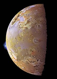
Io, with two plumes erupting from its surface Volcanism on Io, a moon of Jupiter, is represented by the presence of volcanoes, volcanic pits and lava flows on the surface. Io's volcanic activity was discovered in 1979 by Linda Morabito, an imaging scientist working on Voyager 1. Observations of Io by passing spacecraft and Earth-based astronomers have revealed more than 150 active volcanoes. , up to 400 such volcanoes are predicted to exist based on these observations.[outdated statistic] Io's volcanism makes the satellite one of only four known currently volcanically or cryovolcanically active worlds in the Solar System (the others being Earth, Saturn's moon Enceladus, and Neptune's moon Triton.)
First predicted shortly before the Voyager 1 flyby, the heat source for Io's volcanism comes from tidal heating produced by its forced orbital eccentricity. This differs from Earth's internal heating, which is derived primarily from radioactive isotope decay and primordial heat of accretion. Io's eccentric orbit leads to a slight difference in Jupiter's gravitational pull on the satellite between its closest and farthest points on its orbit, causing a varying tidal bulge. This variation in the shape of Io causes frictional heating in its interior. Without this tidal heating, Io might have been similar to the Moon, a world of similar size and mass, geologically dead and covered with numerous impact craters. (Full article...)
Image 3
Map showing location of epicenter of earthquake relative to Ambato; the bullseye is the epicenter; small blue lines are rivers
The 1949 Ambato earthquake was the deadliest earthquake in the Western Hemisphere in five years. On August 5, 1949, it struck Ecuador's Tungurahua Province southeast of its capital Ambato and killed 5,050 people. Measuring 6.4 on the Ms scale, it originated from a hypocenter 15 km beneath the surface. The nearby villages of Guano, Patate, Pelileo, and Pillaro were destroyed, and the city of Ambato suffered heavy damage. The earthquake flattened buildings and subsequent landslides caused damage throughout the Tungurahua, Chimborazo, and Cotopaxi Provinces. It disrupted water mains and communication lines and opened a fissure into which the small town of Libertad sank. Moderate shaking from the event extended as far away as Quito and Guayaquil.
Earthquakes in Ecuador stem from two major interrelated tectonic areas: the subduction of the Nazca Plate under the South American Plate and the Andean Volcanic Belt. The 1949 Ambato earthquake initially followed an intersection of several northwest-southeast-trending faults in the Inter-Andean Valley which were created by the subduction of the Carnegie Ridge. Strata of rock cracked as the earthquake ruptured the faults, sending out powerful shock waves. Today threats exist throughout the country from both interplate and intraplate seismicity. (Full article...)
Image 4
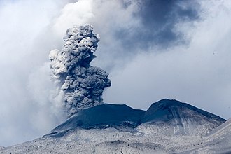
The Volcano with thick black scoria in the foreground
The Volcano, also known as Lava Fork volcano, is a small cinder cone in the Boundary Ranges of the Coast Mountains in northwestern British Columbia, Canada. It is located approximately 60 km (40 mi) northwest of the small community of Stewart near the head of Lava Fork. With a summit elevation of 1,656 m (5,433 ft) and a topographic prominence of 311 m (1,020 ft), it rises above the surrounding rugged landscape on a remote mountain ridge that represents the northern flank of a glaciated U-shaped valley.
Lava Fork volcano is associated with a small group of volcanoes called the Iskut volcanic field. This forms part of the much larger Northern Cordilleran Volcanic Province, which extends from the Alaska–Yukon border to near the port city of Prince Rupert, British Columbia. Eruptive activity at The Volcano is relatively young compared to most other volcanoes in the Northern Cordilleran Volcanic Province. Geologic studies have shown that The Volcano and its eruptive products were emplaced in the last 400 years; this is well after the last glacial period, which ended about 10,000 years ago. (Full article...)
Image 5
The Qayen earthquake, also known as the Ardekul or Qaen earthquake, struck northern Iran's Khorasan Province in the vicinity of Qaen on May 10, 1997 at 07:57 UTC (12:57 local time). The largest in the area since 1990, the earthquake registered 7.3 on the moment magnitude scale and was centered approximately 270 kilometers (170 mi) south of Mashhad on the village of Ardekul. The third earthquake that year to cause severe damage, it devastated the Birjand–Qayen region, killing 1,567 and injuring more than 2,300. The earthquake—which left 50,000 homeless and damaged or destroyed over 15,000 homes—was described as the deadliest of 1997 by the United States Geological Survey. Some 155 aftershocks caused further destruction and drove away survivors. The earthquake was later discovered to have been caused by a rupture along a fault that runs underneath the Iran–Afghanistan border.
Damage was eventually estimated at $100 million, and many countries responded to the emergency with donations of blankets, tents, clothing, and food. Rescue teams were also dispatched to assist local volunteers in finding survivors trapped under the debris. The destruction around the earthquake's epicenter was, in places, almost total; this has been attributed to poor construction practices in rural areas, and imparted momentum to a growing movement for changes in building codes for earthquake-safe buildings. With 1 in 3,000 deaths in Iran attributable to earthquakes, a US geophysicist has suggested that a country-wide rebuilding program would be needed to address the ongoing public safety concerns. (Full article...)
Because the arrangement of atoms in diamond is extremely rigid, few types of impurity can contaminate it (two exceptions are boron and nitrogen). Small numbers of defects or impurities (about one per million of lattice atoms) can color a diamond blue (boron), yellow (nitrogen), brown (defects), green (radiation exposure), purple, pink, orange, or red. Diamond also has a very high refractive index and a relatively high optical dispersion. (Full article...)
Image 8
Mauna Loa as seen from the air. Hualālai is visible in the background.
Mauna Loa (/ˌmɔːnəˈloʊ.ə/ or /ˌmaʊnəˈloʊ.ə/; Hawaiian: [ˈmɐwnəˈlowə]; lit.'Long Mountain') is one of five volcanoes that form the Island of Hawaii in the U.S. state of Hawaii in the Pacific Ocean. Mauna Loa is Earth's largest active volcano by both mass and volume. It was historically considered to be the largest volcano on Earth until Tamu Massif was discovered to be larger. Mauna Loa is a shield volcano with relatively gentle slopes, and a volume estimated at 18,000 cubic miles (75,000 km3), although its peak is about 125 feet (38 m) lower than that of its neighbor, Mauna Kea. Lava eruptions from Mauna Loa are silica-poor and very fluid, and tend to be non-explosive.
Mauna Loa has likely been erupting for at least 700,000 years, and may have emerged above sea level about 400,000 years ago. Some dated rocks are 470,000 years old. The volcano's magma comes from the Hawaii hotspot, which has been responsible for the creation of the Hawaiian Island chain over tens of millions of years. The slow drift of the Pacific Plate will eventually carry Mauna Loa away from the hotspot within 500,000 to one million years from now, at which point it will become extinct. (Full article...)
Image 9
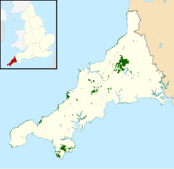
Map of SSSIs in Cornwall within the UK There are 167 Sites of Special Scientific Interest (SSSIs) in Cornwall (including the Isles of Scilly). Cornwall, in the south-west of England, UK, has a population of 575,413 (2022) across an area of 3,545 km2 (875,988.6 acres), making it one of the least densely populated counties within England. The north coast of Cornwall falls on the Celtic Sea in the Atlantic Ocean, which also surrounds the Isles of Scilly, the south coast falls on the English Channel and the county is bounded by the River Tamar, forming the border with Devon, to the east. Cornish geology consists mainly of rocks from the Devonian and Carboniferous geological periods. Granite forms a large part of these, with mineralisations of tin, copper, lead and arsenic having been mined in the area. This gives rise to many distinct habitats, with strong marine influences, including sand dunes, rocky reefs, stacks and headlands as well as heathland, moorland and unusual river profiles.
The Mono–Inyo Craters are a volcanic chain of craters, domes and lava flows in Mono County, Eastern California. The chain stretches 25 miles (40 km) from the northwest shore of Mono Lake to the south of Mammoth Mountain. The Mono Lake Volcanic Field forms the northernmost part of the chain and consists of two volcanic islands in the lake and one cinder cone volcano on its northwest shore. Most of the Mono Craters, which make up the bulk of the northern part of the Mono–Inyo chain, are phreatic (steam explosion) volcanoes that have since been either plugged or over-topped by rhyolite domes and lava flows. The Inyo volcanic chain form much of the southern part of the chain and consist of phreatic explosion pits, and rhyolitic lava flows and domes. The southernmost part of the chain consists of fumaroles and explosion pits on Mammoth Mountain and a set of cinder cones south of the mountain; the latter are called the Red Cones.
Eruptions along the narrow fissure system under the chain began in the west moat of Long Valley Caldera 400,000 to 60,000 years ago. Mammoth Mountain was formed during this period. Multiple eruptions from 40,000 to 600 years ago created the Mono Craters and eruptions 5,000 to 500 years ago formed the Inyo volcanic chain. Lava flows 5,000 years ago built the Red Cones, and explosion pits on Mammoth Mountain were excavated in the last 1,000 years. Uplift of Paoha Island in Mono Lake about 250 years ago is the most recent activity. These eruptions most likely originated from small magma bodies rather than from a single, large magma chamber like the one that produced the massive Long Valley Caldera eruption 760,000 years ago. During the past 3,000 years, eruptions have occurred every 250 to 700 years. In 1980, a series of earthquakes and uplift within and south of Long Valley Caldera indicated renewed activity in the area. (Full article...)
Mudpots lined up above a volcanic fissure at Hverarönd, Iceland
A mudpot, or mud pool, is a type of acidic hot spring, or fumarole, with limited water. It usually takes the form of a pool of bubbling mud, as a result of the acid and microorganisms decomposing surrounding rock into clay and mud. (Full article...)
Hans Wilhelm Stille (8 October 1876 – 26 December 1966) was an influential Germangeologist working primarily on tectonics and the collation of tectonic events during the Phanerozoic. Stille adhered to the contracting Earthhypothesis and together with Leopold Kober he worked on the geosyncline theory to explain orogeny. Stille's ideas emerged in the aftermath of Eduard Suess' book Das Antlitz der Erde (1883–1909). Stille's and Kober's school of thought was one of two that emerged in the post-Suess era the other being headed by Alfred Wegener and Émile Argand. This competing view rejected Earth contraction and argued for continental drift. As Stille opposed continental drift he came to be labelled a "fixist".
... that Frederick Murray Trotter had a distinguished career as a field geologist despite losing a part of his skull and an eye to shrapnel during World War I?
Animated, colour-coded map showing some continents and the region of Oceania (purple), which includes the continent of Australia. Depending on the convention and model, some continents may be consolidated or subdivided.
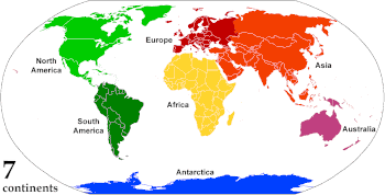
A continent is any of several large geographicalregions. Continents are generally identified by convention rather than any strict criteria. A continent could be a single landmass or a part of a very large landmass, as in the case of Asia or Europe. Due to this, the number of continents varies; up to seven or as few as four geographical regions are commonly regarded as continents. Most English-speaking countries recognize seven regions as continents. In order from largest to smallest in area, these seven regions are Asia, Africa, North America, South America, Antarctica, Europe, and Australia. Different variations with fewer continents merge some of these regions; examples of this are merging North America and South America into America, Asia and Europe into Eurasia, and Africa, Asia, and Europe into Afro-Eurasia. (Full article...)
Image 4
Imaging from NASA's Shuttle Radar Topography Mission STS-99 reveals part of the diameter ring of the crater in the form of a shallow circular trough. Numerous cenotes (sinkholes) cluster around the trough marking the inner crater rim.
The Mariana Trench is an oceanic trench located in the western Pacific Ocean, about 200 kilometres (124 mi) east of the Mariana Islands; it is the deepest oceanic trench on Earth. It is crescent-shaped and measures about 2,550 km (1,580 mi) in length and 69 km (43 mi) in width. The maximum known depth is 10,984 ± 25 metres (36,037 ± 82 ft; 6,006 ± 14 fathoms; 6.825 ± 0.016 mi) at the southern end of a small slot-shaped valley in its floor known as the Challenger Deep. The deepest point of the trench is more than 2 km (1.2 mi) farther from sea level than the peak of Mount Everest. (Full article...)
Curiosity is a car-sized rover designed to explore the crater Gale on Mars as part of NASA's Mars Science Laboratory mission. It was launched from Cape Canaveral in November 2011 and landed on Aeolis Palus inside Gale on August 6, 2012, at 05:17 UTC. Curiosity's landing site, nicknamed Bradbury Landing, was less than 2.4 km (1.5 mi) from the center of the rover's touchdown target after a 560-million km (350-million mi) journey. The rover's goals include an investigation of the Martian climate and geology; assessment of whether the selected field site inside Gale has ever offered environmental conditions favorable for microbial life, including investigation of the role of water; as well as planetary habitability studies in preparation for human exploration.
This picture is a self-portrait of Curiosity on Mars at the "Big Sky" drilling site, where it collected a rock sample at the foothills of Aeolis Mons (Mount Sharp) in October 2015. The photograph combines dozens of images taken by the Mars Hand Lens Imager (MAHLI) camera at the end of the rover's robotic arm; the arm itself is not included, although its shadow is visible on the ground. Wrist motions and turret rotations on the arm allowed MAHLI to acquire the mosaic's component images.
The Lambert azimuthal equal-area projection is a projection used for mapping a sphere to a disk. It accurately represents area in all regions of the sphere, but it does not accurately represent angles. It is used in scientific disciplines such as geology for plotting the orientations of lines in three-dimensional space, and by the National Atlas of the US in its online map-making application.
A geological map of Yosemite National Park (full size), showing the Cathedral Peak Granodiorite, the largest unit in the Tuolumne Intrusive Suite, which in turn is the largest granitic suite in the park. Cathedral Peak Granodiorite Rest of the Tuolumne Intrusive Suite
This false-color mosaic showing compositional variations in the geology of the Moon was constructed from a series of 53 images taken through three spectral filters by the imaging system of the Galileo spacecraft. Bright pinkish areas are highlands materials, such as those surrounding the oval lava-filled Mare Crisiumimpact basin toward the bottom. Blue to orange shades indicate volcanic lava flows. To the left of Crisium, the dark blue Mare Tranquillitatis is richer in titanium than the green and orange maria above it. Thin mineral-rich soils associated with relatively recent impacts are represented by light blue colors. The monochrome band on the right edge shows the unretouched surface of the moon.


 Vital article

 Featured biography

.jpg)


 Categories
 Cartographic relief depiction showing the varying age of bedrock underlying North America. This image combines a geologic map and a shaded relief image. This combination reveals the geologic history of North America through the interrelation of rock type, topography and time. Regional surface processes as well as continent-scale tectonic events are exposed in the three dimensions of space and the fourth dimension, geologic time. From most recent to oldest, age is indicated by color: yellow, green, blue, red.
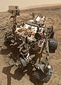 Curiosity is a car-sized rover designed to explore the crater Gale on Mars as part of NASA's Mars Science Laboratory mission. It was launched from Cape Canaveral in November 2011 and landed on Aeolis Palus inside Gale on August 6, 2012, at 05:17 UTC. Curiosity's landing site, nicknamed Bradbury Landing, was less than 2.4 km (1.5 mi) from the center of the rover's touchdown target after a 560-million km (350-million mi) journey. The rover's goals include an investigation of the Martian climate and geology; assessment of whether the selected field site inside Gale has ever offered environmental conditions favorable for microbial life, including investigation of the role of water; as well as planetary habitability studies in preparation for human exploration.
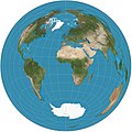 Map: Strebe, using GeocartThe Lambert azimuthal equal-area projection is a projection used for mapping a sphere to a disk. It accurately represents area in all regions of the sphere, but it does not accurately represent angles. It is used in scientific disciplines such as geology for plotting the orientations of lines in three-dimensional space, and by the National Atlas of the US in its online map-making application.
 Map: Grandiose, based on a map by the United States Geological SurveyA geological map of Yosemite National Park (full size), showing the Cathedral Peak Granodiorite, the largest unit in the Tuolumne Intrusive Suite, which in turn is the largest granitic suite in the park.
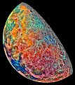 Image credit: Galileo spacecraftThis false-color mosaic showing compositional variations in the geology of the Moon was constructed from a series of 53 images taken through three spectral filters by the imaging system of the Galileo spacecraft. Bright pinkish areas are highlands materials, such as those surrounding the oval lava-filled Mare Crisium impact basin toward the bottom. Blue to orange shades indicate volcanic lava flows. To the left of Crisium, the dark blue Mare Tranquillitatis is richer in titanium than the green and orange maria above it. Thin mineral-rich soils associated with relatively recent impacts are represented by light blue colors. The monochrome band on the right edge shows the unretouched surface of the moon.


 Commons
 Wikibooks
 Wikidata
 Wikinews
 Wikiquote
 Wikisource
 Wikiversity
 Wikivoyage
 Wiktionary


