
Opdorp
Opdorp | |
|---|---|
Village | |
 Geographical centre of Flanders, Belgium | |
 Opdorp Location in Belgium | |
| Coordinates: 51°01′39″N 4°13′13″E / 51.02744°N 4.22040°E | |
| Country | |
| Region | Flemish Region |
| Province | East Flanders |
| Municipality | Buggenhout |
| Area | |
| • Total | 5.05 km2 (1.95 sq mi) |
| Population (2021)[1] | |
| • Total | 2,226 |
| • Density | 440/km2 (1,100/sq mi) |
| Time zone | CET |
Opdorp is one of the three towns making up the municipality of Buggenhout in East Flanders, Belgium. Sometimes it's classified in the Denderstreek.
Opdorp is at the geographical centre of Flanders, Belgium. It is also the point at which three provinces meet: Brabant, Antwerp, and East Flanders.[2]
Opdorp developed around a triangular dries (village square). The dries contains a chapel and the village pump. The town hall, school and former monastery were built around the square.[3]
Gallery
-
 Dries chapel and village pump
 -
 Former brewery Van Den Bossche
 -
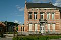
 Former town hall
 -
 St Amandus Church


See also
References
- ^ a b "Bevolking per statistische sector - Sector 42004A2". Statistics Belgium. Retrieved 6 May 2022.
- ^ "Middelpuntwandeling te Opdorp". Pasar (in Dutch). Retrieved 26 October 2020.
- ^ "Opdorp". Agentschap Onroerend Erfgoed (in Dutch). Retrieved 6 May 2022.
External links
 Media related to Opdorp at Wikimedia Commons
- Official site (in Dutch)
This East Flanders location article is a stub. You can help Wikipedia by expanding it. |