
Obertraun
This article has multiple issues. Please help improve it or discuss these issues on the talk page. (Learn how and when to remove these template messages)
|
Obertraun | |
|---|---|
 | |
 Coat of arms | |
 Obertraun Location within Austria | |
| Coordinates: 47°33′31″N 13°41′01″E / 47.55861°N 13.68361°E | |
| Country | Austria |
| State | Upper Austria |
| District | Gmunden |
| Government | |
| • Mayor | Egon Höll (SPÖ) |
| Area | |
| • Total | 87.11 km2 (33.63 sq mi) |
| Elevation | 511 m (1,677 ft) |
| Population (2018-01-01)[2] | |
| • Total | 726 |
| • Density | 8.3/km2 (22/sq mi) |
| Time zone | UTC+1 (CET) |
| • Summer (DST) | UTC+2 (CEST) |
| Postal code | 4831 |
| Area code | +06 131 |
| Website | http://www.obertraun.ooe.gv.at |
Obertraun, Upper Austria (Austrian German: [ˈoːbɐˌtʁaʊ̯n]) is a village in the Salzkammergut, a region in Austria, near the Hallstätter See (Hallstatt Lake) and Hoher Dachstein. It is a popular holiday destination with activities such as skiing and snowboarding in the winter, and mountain biking, swimming and kayaking in the summer.
History
Originally a part of the Duchy of Bavaria, Obertraun became part of the Duchy of Austria during the 12th century. It was occupied several times during the Napoleonic Wars. It has been part of Upper Austria since 1918, and an autonomous town since 1921 (after being part of Hallstatt).
On 15 April 1954, a teacher and fourteen students got lost on a hiking trip on a nearby mountain and all froze to death.[3]
Climate
There is a weather station for the Dachstein Krippenstein ski area, situated at an elevation of 2,050 m (6,726 ft).
| Climate data for Krippenstein: 2050m (1981−2010 normals, extremes 1971−2010) | |||||||||||||
|---|---|---|---|---|---|---|---|---|---|---|---|---|---|
| Month | Jan | Feb | Mar | Apr | May | Jun | Jul | Aug | Sep | Oct | Nov | Dec | Year |
| Record high °C (°F) | 13.5 (56.3) |
12.2 (54.0) |
17.4 (63.3) |
14.4 (57.9) |
21.4 (70.5) |
24.1 (75.4) |
26.0 (78.8) |
25.3 (77.5) |
24.0 (75.2) |
19.8 (67.6) |
14.5 (58.1) |
15.2 (59.4) |
26.0 (78.8) |
| Mean daily maximum °C (°F) | −2.0 (28.4) |
−2.7 (27.1) |
−0.5 (31.1) |
2.3 (36.1) |
7.4 (45.3) |
10.3 (50.5) |
13.0 (55.4) |
12.9 (55.2) |
9.6 (49.3) |
7.1 (44.8) |
1.3 (34.3) |
−1.3 (29.7) |
4.8 (40.6) |
| Daily mean °C (°F) | −5.4 (22.3) |
−6.2 (20.8) |
−4.1 (24.6) |
−1.2 (29.8) |
3.9 (39.0) |
6.6 (43.9) |
9.0 (48.2) |
9.2 (48.6) |
6.0 (42.8) |
3.5 (38.3) |
−2.0 (28.4) |
−4.6 (23.7) |
1.2 (34.2) |
| Mean daily minimum °C (°F) | −8.2 (17.2) |
−8.9 (16.0) |
−6.7 (19.9) |
−3.7 (25.3) |
1.3 (34.3) |
3.9 (39.0) |
6.2 (43.2) |
6.5 (43.7) |
3.4 (38.1) |
0.9 (33.6) |
−4.6 (23.7) |
−7.2 (19.0) |
−1.4 (29.4) |
| Record low °C (°F) | −28.5 (−19.3) |
−24.0 (−11.2) |
−25.2 (−13.4) |
−17.0 (1.4) |
−11.0 (12.2) |
−6.4 (20.5) |
−3.2 (26.2) |
−7.0 (19.4) |
−7.2 (19.0) |
−15.0 (5.0) |
−20.0 (−4.0) |
−24.0 (−11.2) |
−28.5 (−19.3) |
| Average precipitation mm (inches) | 112.5 (4.43) |
110.1 (4.33) |
160.3 (6.31) |
132.7 (5.22) |
140.4 (5.53) |
219.3 (8.63) |
257.8 (10.15) |
211.3 (8.32) |
155.7 (6.13) |
104.1 (4.10) |
124.9 (4.92) |
123.7 (4.87) |
1,852.8 (72.94) |
| Average snowfall cm (inches) | 124.5 (49.0) |
142.8 (56.2) |
224.1 (88.2) |
109.2 (43.0) |
41.1 (16.2) |
16.6 (6.5) |
3.1 (1.2) |
6.9 (2.7) |
23.9 (9.4) |
39.3 (15.5) |
101.7 (40.0) |
138.6 (54.6) |
971.8 (382.5) |
| Average precipitation days (≥ 1.0 mm) | 12.0 | 12.1 | 14.5 | 13.1 | 13.3 | 18.1 | 17.5 | 15.4 | 12.8 | 10.4 | 12.6 | 12.9 | 164.7 |
| Average snowy days (≥ 1 cm) | 31.0 | 28.3 | 31.0 | 30.0 | 28.0 | 12.4 | 2.5 | 1.5 | 5.9 | 11.9 | 24.8 | 30.7 | 238 |
| Source: Central Institute for Meteorology and Geodynamics[4][5] | |||||||||||||
Tourism
In 1895 an "association for beautification of the town and advancement of tourism" was founded, and was the starting point for tourism at Obertraun. The first tourists arrived in the town that summer. In 1947 construction of the Dachstein Cablecar began.
Places of interest
- Freesports Arena Krippenstein: known as freeride area with more than 30 km offpiste routes. Many possible snowshoe trails.[6]
- Dachstein Caves: including an ice cave and a gigantic limestone cave which can be visited during summer.[7]
- Nature protection area Koppenwinkel
References
- ^ "Dauersiedlungsraum der Gemeinden Politischen Bezirke und Bundesländer - Gebietsstand 1.1.2018". Statistics Austria. Retrieved 10 March 2019.
- ^ "Einwohnerzahl 1.1.2018 nach Gemeinden mit Status, Gebietsstand 1.1.2018". Statistics Austria. Retrieved 9 March 2019.
- ^ "The Horrors of Becoming Lost". YouTube. Real Horror. 9 November 2023. Retrieved 14 June 2024.
- ^ "Klimamittel 1981–2010: Lufttemperatur" (in German). Central Institute for Meteorology and Geodynamics. Archived from the original on 21 October 2019. Retrieved 12 July 2024.
- ^ "Klimadaten von Österreich 1971–2000 – Steiermark-Schöckl" (in German). Central Institute for Meteorology and Geodynamics. Archived from the original on 12 October 2019. Retrieved 12 July 2024.
- ^ Freesports Arena Krippenstein
- ^ Dachstein Caves
Gallery
-
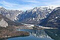 West view of Obertraun
 -
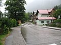 Hallstätterseestrasse
 -
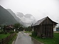 Obertraun
 -
 Obertraun
 -
 Obertraun
 -
 Obertraun
 -
 Obertraun
 -
 Winkler-Traunweg
 -
 Hallstätterseestrasse
 -
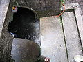 Stormwater system


Places adjacent to Obertraun | |
|---|---|
| International | |
|---|---|
| National | |
This Upper Austria location article is a stub. You can help Wikipedia by expanding it. |