
Muzaffarabad
Muzaffarabad
مظفر آباد | |
|---|---|
City administered by Pakistan | |
 | |
 Interactive map of Muzaffarabad | |
![A map showing Pakistan-administered Azad Kashmir shaded in sage in the disputed Kashmir region[1]](/File:Kashmir_region._LOC_2003626427_-_showing_sub-regions_administered_by_different_countries.jpg) | |
| Coordinates: 34°21′30″N 73°28′20″E / 34.35833°N 73.47222°E | |
| Administering country | Pakistan |
| Territory | Azad Kashmir |
| District | Muzaffarabad |
| Founded by | Sultan Muzaffar Khan |
| Government | |
| • Mayor | Sikandar Gilani (PML(N)) |
| • Deputy Mayor | Khalid Awan (PPP) |
| • Deputy Commissioner | Tahir Mumtaz BPS-18(PAS) |
| • District Police Officer | Mirza Zahid Hussain BPS-18(PSP) |
| Elevation | 737 m (2,418 ft) |
| Population | |
| • City | 149,913 |
| • Rank | 60th, Pakistan |
| Languages | |
| • Official | Urdu[3][4][note 1] |
| • Spoken | |
| Time zone | UTC+05:00 (PST) |
| Calling code | 05822 |
| Website | Muzaffarabad Government Portal (defunct) |
Muzaffarabad (/ˌmʊzəˌfærəˈbæd/;[5] Urdu: مُظَفَّر آباد, IPA: [mʊzəffərɑːbɑːd]) is a city in Pakistani-administered Azad Kashmir in the disputed Kashmir region.[1] It is the largest city and the capital of Azad Kashmir, which is a Pakistani-administered administrative territory.
The city is located in Muzaffarabad District, near the confluence of the Jhelum and Neelum rivers. The district is bounded by the Pakistani province of Khyber Pakhtunkhwa in the west, the Kupwara and Baramulla districts of Indian-administered Jammu and Kashmir in the east, and the Neelum District in the north.
History
Muzaffarabad was founded in 1646 by Sultan Muzaffar Khan, chief of the Bomba tribe[6] who ruled Kashmir.[7] Khan also constructed the Red Fort that same year for the purpose of warding off incursions from the Mughal Empire.
2005 earthquake
The city was near the epicenter of the 2005 Kashmir earthquake, which had a magnitude of 7.6 Mw. The earthquake destroyed about 50 percent of the buildings in the city (including most government buildings) and is estimated to have killed up to 80,000 people in the Pakistani-controlled areas. As of 8 October 2005[update], the Pakistani government's official death toll was 87,350, while other estimates have put the death toll at over 100,000.[8]
Administrative subdivisions

The district of Muzaffarabad is administratively divided into 2 tehsils, which are subdivided into 25 union councils.[9]
- Muzaffarabad
- Pattika (Naseerabad)
Climate
| Climate data for Muzaffarabad (1961–2009) | |||||||||||||
|---|---|---|---|---|---|---|---|---|---|---|---|---|---|
| Month | Jan | Feb | Mar | Apr | May | Jun | Jul | Aug | Sep | Oct | Nov | Dec | Year |
| Record high °C (°F) | 27.0 (80.6) |
29.4 (84.9) |
37.0 (98.6) |
40.5 (104.9) |
46.5 (115.7) |
46.2 (115.2) |
45.0 (113.0) |
40.2 (104.4) |
39.0 (102.2) |
38.3 (100.9) |
33.0 (91.4) |
27.0 (80.6) |
46.5 (115.7) |
| Mean daily maximum °C (°F) | 16.0 (60.8) |
18.0 (64.4) |
22.6 (72.7) |
28.3 (82.9) |
33.5 (92.3) |
37.4 (99.3) |
34.9 (94.8) |
34.0 (93.2) |
33.4 (92.1) |
30.1 (86.2) |
24.2 (75.6) |
18.1 (64.6) |
22.3 (72.1) |
| Mean daily minimum °C (°F) | 3.1 (37.6) |
5.4 (41.7) |
9.7 (49.5) |
14.2 (57.6) |
18.4 (65.1) |
21.9 (71.4) |
22.8 (73.0) |
22.6 (72.7) |
19.4 (66.9) |
13.7 (56.7) |
7.8 (46.0) |
4.1 (39.4) |
11.1 (52.0) |
| Record low °C (°F) | −3.0 (26.6) |
−1.1 (30.0) |
1.0 (33.8) |
6.5 (43.7) |
7.0 (44.6) |
12.0 (53.6) |
15.5 (59.9) |
16.0 (60.8) |
12.4 (54.3) |
6.5 (43.7) |
1.0 (33.8) |
−1.4 (29.5) |
−3 (27) |
| Average rainfall mm (inches) | 101.3 (3.99) |
137.4 (5.41) |
157.3 (6.19) |
109.0 (4.29) |
78.5 (3.09) |
113.6 (4.47) |
328.7 (12.94) |
229.9 (9.05) |
112.6 (4.43) |
45.9 (1.81) |
37.2 (1.46) |
69.0 (2.72) |
1,242.8 (48.93) |
| Average relative humidity (%) (at 12:00 PST) | 50.3 | 46.3 | 40.9 | 38.0 | 33.2 | 34.0 | 52.2 | 57.6 | 48.1 | 42.4 | 48.4 | 54.0 | 37.2 |
| Source: Pakistan Meteorological Department[10] | |||||||||||||
Transport
This section needs expansion. You can help by adding to it. (June 2020) |
Muzaffarabad's public transportation system primarily relies on buses, rickshaws, and small pickup trucks for intracity travel. Following the devastating 2005 earthquake that severely damaged infrastructure, including roads, the city government, with international aid, rebuilt roads, bridges, and other essential infrastructure. However, public transportation remains underdeveloped. Notably, Muzaffarabad lacks a railway system and a functional airport. The nearest railway station is located in the Rawalpindi District of Pakistani Punjab.[11]
Notable people
- Anam Najam, medical doctor and psychiatrist[citation needed]
Gallery
-
 Heightened view of the city on both riverbanks after the 2005 Kashmir earthquake, c. 2014
 -
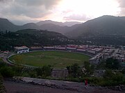 Photo of Muzaffarabad Cricket Stadium
 -
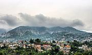 Photo of the city's skyline, c. 2017
 -
 Azad Jammu Kashmir Medical College
 -
 Muzaffarabad City, Azad Kashmir, Pakistan


See also
Notes
- ^ Snedden (2013, p. 176): On p. 29, the census report states that Urdu is the official language of the government of Azad Kashmir, with Kashmiri, Pahari, Gojri, Punjabi, Kohistani, Pushto, and Sheena 'frequently spoken in Azad Kashmir'. Yet, when surveyed about their 'mother tongue', Azad Kashmiris' choices were limited to selecting from Pakistan's major languages: Urdu, Punjabi, Sindhi, Pushto, Balochi, Saraiki, and 'others'; not surprisingly, 2.18 million of Azad Kashmir's 2.97 million people chose 'others'.
References
- ^ a b The application of the term "administered" to the various regions of Kashmir and a mention of the Kashmir dispute is supported by the tertiary sources (a) through (e), reflecting due weight in the coverage. Although "controlled" and "held" are also applied neutrally to the names of the disputants or to the regions administered by them, as evidenced in sources (h) through (i) below, "held" is also considered politicized usage, as is the term "occupied," (see (j) below).
(a) Kashmir, region Indian subcontinent, Encyclopaedia Britannica, retrieved 15 August 2019 (subscription required) Quote: "Kashmir, region of the northwestern Indian subcontinent ... has been the subject of dispute between India and Pakistan since the partition of the Indian subcontinent in 1947. The northern and western portions are administered by Pakistan and comprise three areas: Azad Kashmir, Gilgit, and Baltistan, the last two being part of a territory called the Northern Areas. Administered by India are the southern and southeastern portions, which constitute the state of Jammu and Kashmir but are slated to be split into two union territories.";
(b) Pletcher, Kenneth, Aksai Chin, Plateau Region, Asia, Encyclopaedia Britannica, retrieved 16 August 2019 (subscription required) Quote: "Aksai Chin, Chinese (Pinyin) Aksayqin, portion of the Kashmir region, at the northernmost extent of the Indian subcontinent in south-central Asia. It constitutes nearly all the territory of the Chinese-administered sector of Kashmir that is claimed by India to be part of the Ladakh area of Jammu and Kashmir state.";
(c) "Kashmir", Encyclopedia Americana, Scholastic Library Publishing, 2006, p. 328, ISBN 978-0-7172-0139-6 C. E Bosworth, the University of Manchester Quote: "KASHMIR, kash'mer, the northernmost region of the Indian subcontinent, administered partlv by India, partly by Pakistan, and partly by China. The region has been the subject of a bitter dispute between India and Pakistan since they became independent in 1947";
(d) Osmańczyk, Edmund Jan (2003), Encyclopedia of the United Nations and International Agreements: G to M, Taylor & Francis, pp. 1191–, ISBN 978-0-415-93922-5 Quote: "Jammu and Kashmir: Territory in northwestern India, subject to a dispute between India and Pakistan. It has borders with Pakistan and China."
(e) Talbot, Ian (2016), A History of Modern South Asia: Politics, States, Diasporas, Yale University Press, pp. 28–29, ISBN 978-0-300-19694-8 Quote: "We move from a disputed international border to a dotted line on the map that represents a military border not recognized in international law. The line of control separates the Indian and Pakistani administered areas of the former Princely State of Jammu and Kashmir.";
(f) Skutsch, Carl (2015) [2007], "China: Border War with India, 1962", in Ciment, James (ed.), Encyclopedia of Conflicts Since World War II (2nd ed.), London and New York: Routledge, p. 573, ISBN 978-0-7656-8005-1,The situation between the two nations was complicated by the 1957–1959 uprising by Tibetans against Chinese rule. Refugees poured across the Indian border, and the Indian public was outraged. Any compromise with China on the border issue became impossible. Similarly, China was offended that India had given political asylum to the Dalai Lama when he fled across the border in March 1959. In late 1959, there were shots fired between border patrols operating along both the ill-defined McMahon Line and in the Aksai Chin.
(g) Clary, Christopher, The Difficult Politics of Peace: Rivalry in Modern South Asia, Oxford and New York: Oxford University Press, p. 109, ISBN 9780197638408,Territorial Dispute: The situation along the Sino-Indian frontier continued to worsen. In late July (1959), an Indian reconnaissance patrol was blocked, "apprehended," and eventually expelled after three weeks in custody at the hands of a larger Chinese force near Khurnak Fort in Aksai Chin. ... Circumstances worsened further in October 1959, when a major class at Kongka Pass in eastern Ladakh led to nine dead and ten captured Indian border personnel, making it by far the most serious Sino-Indian class since India's independence.
(h) Bose, Sumantra (2009), Kashmir: Roots of Conflict, Paths to Peace, Harvard University Press, pp. 294, 291, 293, ISBN 978-0-674-02855-5 Quote: "J&K: Jammu and Kashmir. The former princely state that is the subject of the Kashmir dispute. Besides IJK (Indian-controlled Jammu and Kashmir. The larger and more populous part of the former princely state. It has a population of slightly over 10 million, and comprises three regions: Kashmir Valley, Jammu, and Ladakh.) and AJK ('Azad" (Free) Jammu and Kashmir. The more populous part of Pakistani-controlled J&K, with a population of approximately 2.5 million.), it includes the sparsely populated "Northern Areas" of Gilgit and Baltistan, remote mountainous regions which are directly administered, unlike AJK, by the Pakistani central authorities, and some high-altitude uninhabitable tracts under Chinese control."
(i) Fisher, Michael H. (2018), An Environmental History of India: From Earliest Times to the Twenty-First Century, Cambridge University Press, p. 166, ISBN 978-1-107-11162-2 Quote: "Kashmir’s identity remains hotly disputed with a UN-supervised “Line of Control” still separating Pakistani-held Azad (“Free”) Kashmir from Indian-held Kashmir.";
(j) Snedden, Christopher (2015), Understanding Kashmir and Kashmiris, Oxford University Press, p. 10, ISBN 978-1-84904-621-3 Quote:"Some politicised terms also used to describe parts of J&K. These terms include the words 'occupied' and 'held'." - ^ "Statistical Year Book 2019" (PDF). Statistics Azad Jammu and Kashmir. Retrieved 20 April 2020.
- ^ "Kashmir".
- ^ Rahman 1996, p. 226.
- ^ "Muzaffarabad". Lexico UK English Dictionary. Oxford University Press. Archived from the original on 18 May 2021.
- ^ Mir-át-i Mas'údi Archived 2007-09-29 at the Wayback Machine
- ^ Ahmad, Pirzada Irshad (2003). A Hand Book on Azad Jammu & Kashmir. Nawab Sons Publication. ISBN 978-969-530-050-3.
- ^ Stuart, Julia. (1 January 2006) IoS Appeal: Last chance to donate to quake victims Archived 16 January 2006 at the Wayback Machine. News.independent.co.uk. Retrieved on 3 July 2012.
- ^ Information about SPs District Muzaffarabad Archived 6 November 2007 at the Wayback Machine
- ^ "Muzaffarabad Climate Data". Pakistan Meteorological Department. Archived from the original on 13 June 2010. Retrieved 1 October 2019.
- ^ Google Maps. Maps.google.co.uk. Retrieved on 3 July 2012.
Sources
- Rahman, Tariq (1996). Language and politics in Pakistan. Oxford University Press. ISBN 978-0-19-577692-8.
- Snedden, Christopher (2013) [first published as The Untold Story of the People of Azad Kashmir, 2012]. Kashmir: The Unwritten History. HarperCollins India. ISBN 978-9350298985.
External links
Capital: Muzaffarabad | |
| History | |
| Modern history |
|
| Government and politics | |
| Culture and places | |
| Geography | |
| Districts | |
| Cities & Town | |
| Economy | |
| Education | |
| Sport | |
| Others | |
| Mirpur |
| ||||||||
|---|---|---|---|---|---|---|---|---|---|
| Muzaffarabad |
| ||||||||
| Poonch |
| ||||||||
| International | |
|---|---|
| National | |