
Muizenberg
Muizenberg | |
|---|---|
     From top left, Muizenberg Railway Station. Surfer's corner at night (top right). Muizenberg beach (centre). The historic beach changing huts on Muizenberg Beach (bottom left). Het Posthuys, a special historical feature in Muizenberg (bottom right). | |
 | |
| Coordinates: 34°06.3′S 18°28.3′E / 34.1050°S 18.4717°E | |
| Country | South Africa |
| Province | Western Cape |
| Municipality | City of Cape Town |
| Established | 1895 |
| Area | |
| • Total | 15.14 km2 (5.85 sq mi) |
| Population (2011)[1] | |
| • Total | 36,857 |
| • Density | 2,400/km2 (6,300/sq mi) |
| Racial makeup (2011) | |
| • Black African | 39.1% |
| • Coloured | 26.2% |
| • Indian/Asian | 1.3% |
| • White | 27.8% |
| • Other | 5.7% |
| First languages (2011) | |
| • English | 44.3% |
| • Afrikaans | 22.8% |
| • Xhosa | 15.3% |
| • Zulu | 1.4% |
| • Other | 16.2% |
| Time zone | UTC+2 (SAST) |
| Postal code (street) | 7945 |
| PO box | 7950 |
| Area code | (021) 787/788 |
Muizenberg (/ˈmjuːzənbɜːrɡ/ MEW-zən-burg,[2] Dutch for 'mice mountain') is a beach-side town in the Western Cape, South Africa. It is situated where the shore of the Cape Peninsula curves round to the east on the False Bay coast. It is considered to be the main surfing spot in Cape Town and is currently home to a surfing community, centered on the popular 'Surfer's Corner'.
History
Muizenberg was apparently named after Wynand Willem Muijs who commanded a small outpost on the shore of Zandvlei in 1743.[3]
The Battle of Muizenberg was a small but significant military affair that began on 7 August 1795 and ended three months later with the (first) British occupation of the Cape. Thus began the period (briefly interrupted from 1803 to 1806) of British control of the Cape, and subsequently much of Southern Africa. The historical remnant of the Battle of Muizenberg is a site on the hillside overlooking False Bay that holds the remains of a defensive fort started by the Dutch in 1795 and expanded by the British from 1796 onwards. Cannons from that era are mounted at "Het Posthuys", the Muizenberg Park and on the station platform.
The railway from Cape Town, which for twenty years stopped at Wynberg, was extended to Muizenberg in 1882. Muizenberg started as a place for holiday homes for the rich after the discovery of gold in the Witwatersrand in 1886. Muizenberg Municipality was established in 1895. It merged with Kalk Bay in 1897. In 1910 a library opened next to the Natale Labia, and a year later a post office opened. In 1911 the first pavilion, a wooden one, was built. In the twentieth century, Muizenberg was the premier summer destination among Southern African Jews.[4] The post office was bombed in 1986, injuring the postman.[5]
Buildings
The famous architect, Sir Herbert Baker, designed his house "Sand Hills" on Atlantic Road, was the architect for "Vergenoegd" further along the same road, and designed "Coel an Mar" on Main Road.
Many of the buildings in Muizenberg date from the resort town's heyday and are built in the art deco style. At its peak the Muizenberg beachfront attracted masses of holiday-makers and the beach in front of the pavilion earned the name "The Snake Pit". It boasted a large Jewish population that attended the synagogue in Camp Rd. The community is celebrated in a book called "The Stetl by the Sea".
Rhodes Cottage
Rhodes' Cottage is a small house on the seafront that Cecil Rhodes bought as a holiday cottage and this was where he died in 1902. The house is preserved as a museum dedicated to Rhodes' life and is open to the public.[citation needed]
Het Posthuys
Het Posthuys is one of the oldest buildings in South Africa,[6] originally erected in February 1673: a year before the Castle in Cape Town was occupied. It was built by the Dutch East India Company (Vereenigde Oost-Indische Compagnie or VOC), originally as a three-roomed signal station, and used as a military observation post, and subsequently used as a toll-house to levy a tax on farmers passing by to sell their produce to ships lying in Simon's Bay. One of the early postholders was Sergeant Muys (meaning "mouse"), from whom Muizenberg (formerly Muysenbergh and Muys Zijn Bergh (Muys' mountain) before that) gets its name. After a varied career as a police station, stables, brothel, hotel and private house the building was identified for what it was in the 1980s and restored with funds from Anglo American Corporation. The house is cared for by the Muizenberg Historical Conservation Society and contains a small collection of photos and items of interest relating to early days in Muizenberg. It is open to the public.
Casa Labia
The Muizenberg Battle site flanks the home of the first Italian Envoy Extraordinary and Minister Plenipotentiary to South Africa, Prince Natale Labia. Originally called "The Fort" after the site of the battle, it now bears the name Casa Labia and is a restaurant, conference centre and music venue. The house was built by skilled Italian artisans and houses part of the Labia family's extensive art collection.
Behind Casa Labia lies the grave site of Abe Bailey, one of South Africa's early and important mine magnates. The graveyard is maintained by the Muizenberg Historical Conservation Society. One of the few houses on the sea side of the railway line, is the thatched cottage owned by Bailey and called Bailey's Cottage. This is owned by the South African Navy.
Pavilion
There have been three pavilions built in Muizenberg - the first was a wooden one built in 1911. The next had bathing cubicles, a tearoom, and a 900-seat theatre, built in 1929. This was demolished in 1970, and a third one, still standing, was built.
Muizenberg Shul

Muizenberg Shul is a modern orthodox synagogue on Camp Road. The red-and-white painted building dates from the 1920s and ‘30s. The synagogue has a full-time rabbi and is open for Shabbat services and for the Jewish holidays.[7][8]
In 2022, the Shul's rabbi, Ryan Newman said: “Muizenberg may be the largest Jewish community in South Africa during the holidays. We have a minyan of over fifty men every single day. You can’t walk a minute on the beach without seeing a group of people you know sitting together. The amazing thing is that you see Jews here from across the spectrum of Orthodoxy. You have people – and often very different rabbis – from Chabad, Mizrachi, Ohr Somayach, etc. all joining together in a single shul.”[9]
Present day

Muizenberg has a fine, long beach that in effect stretches all the way round the top of False Bay to the Strand, a distance of over 20 km. False Bay, known for its population of White Sharks, also has a shark watch service that operates from Muizenberg, signalling alerts when sharks come in proximity of bathers at the main beach and surfers at Surfer's Corner. Above Muizenberg there is a line of steep cliffs that is very popular as a venue for rock climbing. However, certain parts of the cliff are off-limits to climbers when birds nest on the ledges.
The Zandvlei estuary enters the ocean in Muizenberg. The estuary is one of the most important estuaries for fish spawning on the coastline and is home to the Imperial Yacht Club, Peninsula Canoe Club and Sandvlei Sea Scout Base.
Educational establishments
Muizenberg houses one of the False Bay College campuses in the Cinnabar Building, a high-rise apartment tower. The college, a Public Further Education and Training Institution (FET), was established in September 2002 when the South Peninsula College (established 1970) and the Westlake College (established 1954) were merged.[10] Muizenberg is also home to the African Institute for Mathematical Sciences (AIMS), a pan-African centre for education and research in mathematical sciences.
Beach front


Muizenberg is home to the well known "Surfers Corner", there is a range of restaurants and coffee shops in the area such as Knead Bakery, Bootlegger, Kauai and Starbucks. Surf shops are also very present in the area.
Agatha Christie, famous author and playwright, wrote that after nursing duty she would daily take the train to Muizenberg to go surfing.[11][12]
Geography
Muizenberg is located approximately 27 km south-east of Cape Town’s CBD by road and is bounded by Kalk Bay to the south-west, the suburbs of Lavender Hill, Seawinds, Coniston Park, Sheraton Park, Retreat and Westlake to the north and Grassy Park to the north-west.[13]
The older part of the town known as Muizenberg Village occupies the foot slopes of the Muizenberg Mountain, whilst the newer suburbs have spread eastwards along the flat expanse of land, known as the Cape Flats, bordering the lake of Zandvlei to the west.
The municipal boundaries of Muizenberg comprises Muizenberg Village and the following other suburbs:[14]
- Capricorn
- Costa da Gama
- Lakeside
- Marina da Gama
- St James
- Stonehurst Mountain Estate
- Vrygrond
Transport
Rail
Muizenberg is situated on the main commuter line between Cape Town and Simon’s Town, known as the Southern Line which is operated by Metrorail. Metrorail currently operates commuter railway services in Muizenberg from the False Bay, Lakeside, Muizenberg, and St James railway stations to Cape Town, Kalk Bay, Fish Hoek and Simon’s Town.
Roads
The main thoroughfare through Muizenberg is the M4 (Main Road) which roughly runs in a north-south direction from Cape Town towards Kalk Bay, Fish Hoek and Simon’s Town. The R310 is another major route roughly running NE to SW from Stellenbosch and Mitchells Plain to Muizenberg and runs through Muizenberg as Atlantic Road and Baden Powell Drive.
Muizenberg is also intersected by other metropolitan routes within the City of Cape Town including the M5 (Prince George Drive) linking Muizenberg with Cape Town and Milnerton and the M75 (Boyes Drive) skirting above Muizenberg along the lower slopes of the Muizenberg Mountains towards Kalk Bay.
The M3 expressway (Simon van der Stel Freeway) runs northwards to Cape Town’s CBD from the intersection with the M42 (Steenberg Drive) in Westlake. The M42 then connects the M3 to Muizenberg from the intersection with the M4 near Lakeside.
Nearby places of interest
- Zandvlei Estuary Nature Reserve
- Rondevlei Nature Reserve
- Kalk Bay Harbour
- Peck's Valley
- Table Mountain Nature Reserve above Boyes Drive
References
- ^ a b c d "Main Place Muizenberg". Census 2011.
- ^ Lass, Roger (1990), "A 'standard' South African vowel system", in Ramsaran, Susan (ed.), Studies in the Pronunciation of English: A Commemorative Volume in Honour of A.C. Gimson, Routledge, p. 283, ISBN 978-0-41507180-2
- ^ Murray, Tony; Brown, Cate; Dollar, Evan; Day, Jenny; Beuster, Hans; Haskins, Candice; Boucher, Charlie; Turpie, Jane; Wood, Julia; Thompson, Martin; Lamberth, Steve; van Niekerk, Lara; Impson, Dean; Magoba, Rembu; Petersen, Chantel; Davey, Denis; Noffke, Mandy; Hay, Rowena; Hartnady, Chris; Ewart-Smith, Justine; Burger, Marius; Fairburn, Emily; Ractliffe, Geordie; Day, Liz; Luger, Mike; Lannas, Katy; Ndiitwani-Nyamande, Tovhowani (2009). Brown, Cate; Magoba, Rembu (eds.). Rivers and Wetlands of Cape Town (Part 2) (PDF). Project No: K5/1691 (Report). Water Research Commission. pp. 179–380.
- ^ Memories of Muizenberg The Jerusalem Post. 4 April 2012
- ^ Bomb kills 4 in South African enclave The New York Times. 3 August 1986
- ^ ArteFacts
- ^ Muizenberg Synagogue Retrieved on 27 September 2023
- ^ First full-time rabbi at Muizenberg shul in decades South African Jewish Report. 2 July 2020
- ^ Muizenberg Jewish Life. 30 March 2022
- ^ Falsebay College
- ^ "Agatha Christie learned to surf in the 1920s". Surfertoday. Retrieved 29 April 2022.
- ^ "Agatha Christie's surfing secret revealed". the Guardian. 29 July 2011. Retrieved 29 April 2022.
- ^ "Distance Muizenberg, Cape-Town, Western-Cape, ZAF > Cape-Town, Western-Cape, ZAF - Air line, driving route, midpoint". www.distance.to. Retrieved 25 January 2023.
- ^ "Census 2011: Main Place: Muizenberg". census2011.adrianfrith.com. Retrieved 30 May 2023.
Gallery
-
 Rhodes Cottage
 -
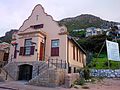 Muizenberg's historical post office
 -
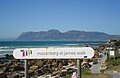 Walkway from Muizenberg to the neighboring community of St James
 -
 Muizenberg with Zandvlei, centre


