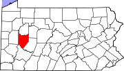
McVille, Pennsylvania
McVille, Pennsylvania | |
|---|---|
Unincorporated community | |
| Coordinates: 40°43′33″N 79°36′10″W / 40.72583°N 79.60278°W | |
| Country | United States |
| State | Pennsylvania |
| County | Armstrong |
| Township | South Buffalo |
| Elevation | 1,073 ft (327 m) |
| Time zone | UTC-5 (Eastern (EST)) |
| • Summer (DST) | UTC-4 (EDT) |
| GNIS feature ID | 1180808[1] |
McVille is an unincorporated community in South Buffalo Township, Armstrong County, Pennsylvania, United States.[1] The community is 6.6 miles (10.6 km) northeast of Freeport along PA-128, south of Nicholson Run. McVille Airport lies 0.7 miles (1.1 km) to the northeast on Ford City Road at 40°44′07″N 79°35′57″W / 40.73528°N 79.59917°W. McVille Union Cemetery is located nearby, on the north side of McVille Road, at 40°43′39″N 79°36′18″W / 40.72750°N 79.60500°W.
History
The McVille post office was established on May 5, 1864, with Robert McCaslin as postmaster.[2][3] It remained in operation until 1903.[2] That same year, 1864, John Boyd opened a store about 190 yards northwest of the steam mill then located on the west side of Nicholson's run.[3] The first and only resident clergyman at McVille in 1883 was Rev. Jacob F. Dean, Baptist, who settled there in 1868.[3]
McVill P.O. appears in the 1876 Atlas of Armstrong County, Pennsylvania.[4]
References
- ^ a b "McVille". Geographic Names Information System. United States Geological Survey, United States Department of the Interior.
- ^ a b "Post Offices". Jim Forte Postal History. Retrieved November 6, 2018.
- ^ a b c Robert Walter Smith (1883). "History of Armstrong County Pennsylvania, Chapter 20, page 442". Chicago: Waterman, Watkins. Retrieved November 7, 2018.
- ^ "Atlas of Armstrong County Pennsylvania, page 69". Pomeroy, Whitman & Co. 1876. Retrieved November 9, 2018.


