
Masterton
Masterton
Whakaoriori (Māori) | |
|---|---|
 | |
 Location of Masterton District in North Island | |
| Coordinates: 40°58′S 175°39′E / 40.97°S 175.65°E | |
| Country | New Zealand |
| Region | Greater Wellington |
| District | Masterton District |
| Town founded | 1854 |
| NZ Parliament | Ikaroa-Rāwhiti (Māori) Wairarapa |
| Government | |
| • Mayor | Gary Caffell |
| • Deputy Mayor | Bex Johnson |
| • MPs | Mike Butterick (National) Cushla Tangaere-Manuel (Labour) |
| • Territorial authority | Masterton District Council |
| Area | |
| • Territorial | 2,300.17 km2 (888.10 sq mi) |
| • Urban | 22.45 km2 (8.67 sq mi) |
| Elevation | 69 m (420 ft) |
| Population (June 2023)[2] | |
| • Territorial | 29,100 |
| • Density | 13/km2 (33/sq mi) |
| • Urban | 22,600 |
| • Urban density | 1,000/km2 (2,600/sq mi) |
| Time zone | UTC+12 (NZST) |
| • Summer (DST) | UTC+13 (NZDT) |
| Postcode | 5810 |
| Area code | 06 |
| Website | www |
Masterton (Māori: Whakaoriori)[3] is a large town in the Greater Wellington Region of New Zealand that operates as the seat of the Masterton District (a territorial authority or local-government district). It is the largest town in the Wairarapa, a region separated from Wellington by the Remutaka ranges. It stands on the Waipoua stream between the Ruamāhunga and Waingawa Rivers – 100 kilometres north-east of Wellington and 39.4 kilometres south of Eketāhuna.
Masterton has an urban population of 22,600, and a district population of 29,100 (June 2023).[2]
Masterton businesses includes services for surrounding farmers. Three new industrial parks are being developed[when?] in Waingawa, Solway and Upper Plain. The town functions as the headquarters of the annual Golden Shears sheep-shearing competition.
Suburbs
Masterton suburbs include:
- Lansdowne, Te Ore Ore on the northern side
- Eastside and Homebush on the eastern side
- Upper Plain, Fernridge, Ngaumutawa, Ākura and Masterton West on the western side
- Kuripuni and Solway on the southern side
History and culture
Early history
Masterton was founded in 1854 by the Small Farms Association. The association was led by Joseph Masters – after whom the town was named – and aimed to settle working people in villages and on the land. At first Masterton grew slowly, but as its farming hinterland became more productive it began to prosper.
In the 1870s, it overtook Greytown as Wairarapa's major town. It became a borough in 1877 and was reached by the railway line from Wellington in 1880. The railway became for a time the main line from Wellington to the north of New Zealand, and its arrival cemented the town's position as the Wairarapa region's main market and distribution centre.
Waipoua timber mill was producing butter boxes as early as 1884.[4]
In April 1965, one of the country's worst industrial accidents occurred at the General Plastics Factory on 170 Dixon Street.[5]
During World War II two battalions of the United States Marine Corps were stationed in Masterton.[6]
-
 The railway station opened 1880, demolished 1967
 -
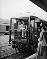 Railway station, 15 January 1954
 -
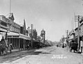 Queen Street in the early 1900s
 -
 The Post Office opened 1900, demolished 1960
 -
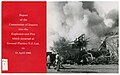 4 killed in the General Plastics Explosion and Fire 1965
.jpg)
.jpg)
_(cropped).jpg)
.jpg)
_Ltd._Explosion_and_Fire_(1965)_(26271497746).jpg)
Modern history
In essence, providing support services for rural industry – living off the sheep's back – Masterton's real growth ended with that sector's retrenchment after the 1974 British entry to the trade and political grouping now the European Union. Efforts to decentralise industry to New Zealand's provinces gave Masterton a print works and some other industries, but the lost economic activity was not restored.
From the 1970s, people and businesses left for opportunities elsewhere. In the 1980s, with government deregulation and protective tariffs lifted, more businesses closed, and the town declined further.[7]
It did not quite qualify to be a city by 1989 when the minimum population requirement for that status was lifted from 20,000 to 50,000.
Marae
Te Oreore marae and Ngā Tau e Waru meeting house, located in Masterton, is affiliated with the iwi of Ngāti Kahungunu and its hapū of Kahukuraawhitia, Kahukuranui, Ngāti Te Hina, Tahu o Kahungunu, Tamahau and Whiunga, and with the iwi of Rangitāne, and its hapū of Hinetearorangi, Ngāi Tamahau, Ngāti Hāmua, Ngāti Taimahu, Ngāti Tangatakau, Ngāti Te Noti, Ngāti Te Raetea and Ngāti Te Whātui.
In October 2020, the Government committed $2,179,654 from the Provincial Growth Fund to upgrade Ngāi Tumapuhia a Rangi ki Okautete, Motuwairaka, Pāpāwai, Kohunui, Hurunui o Rangi and Te Oreore marae. The projects were expected to create 19.8 full time jobs.[8]
Another local marae, Ākura Marae, is affiliated with the Ngāti Kahungunu hapū of Ngāti Te Ahuahu and Ngāti Te Hina. and with the Rangitāne hapū of Ngāti Mātangiuru and Ngāti Te Hina.[9][10]
Demographics

Masterton District covers 2,300.17 km2 (888.10 sq mi)[1] and had an estimated population of 29,100 as of June 2023,[2] with a population density of 13 people per km2. The Masterton urban area covers 22.45 km2 (8.67 sq mi)[1] and had an estimated population of 22,600 as of June 2023,[2] with a population density of 1,007 people per km2.
| Year | Pop. | ±% p.a. |
|---|---|---|
| 1891 | 3,114 | — |
| 1896 | 3,493 | +2.32% |
| 1901 | 3,949 | +2.48% |
| 1906 | 3,723 | −1.17% |
| 1911 | 5,182 | +6.84% |
| 1916 | 5,560 | +1.42% |
| 1921 | 7,820 | +7.06% |
| 1926 | 8,575 | +1.86% |
| 1936 | 8,950 | +0.43% |
| 1945 | 9,480 | +0.64% |
| 1951 | 11,545 | +3.34% |
| 1956 | 13,000 | +2.40% |
| 1961 | 16,944 | +5.44% |
| 1966 | 19,116 | +2.44% |
| 1971 | 20,194 | +1.10% |
| 1976 | 19,460 | −0.74% |
| 1981 | 18,545 | −0.96% |
| 1986 | 20,145 | +1.67% |
| 1991 | 22,566 | +2.30% |
| 1996 | 22,755 | +0.17% |
| 2001 | 22,614 | −0.12% |
| 2006 | 22,623 | +0.01% |
| 2013 | 23,352 | +0.45% |
| 2018 | 25,557 | +1.82% |
| Source: [11] | ||
Masterton District had a population of 25,557 at the 2018 New Zealand census, an increase of 2,205 people (9.4%) since the 2013 census, and an increase of 2,934 people (13.0%) since the 2006 census. There were 9,936 households, comprising 12,372 males and 13,185 females, giving a sex ratio of 0.94 males per female. The median age was 43.2 years (compared with 37.4 years nationally), with 4,968 people (19.4%) aged under 15 years, 4,371 (17.1%) aged 15 to 29, 10,857 (42.5%) aged 30 to 64, and 5,361 (21.0%) aged 65 or older.
Ethnicities were 84.7% European/Pākehā, 21.3% Māori, 4.0% Pasifika, 3.9% Asian, and 1.6% other ethnicities. People may identify with more than one ethnicity.
The percentage of people born overseas was 12.9, compared with 27.1% nationally.
Although some people chose not to answer the census's question about religious affiliation, 50.2% had no religion, 37.7% were Christian, 1.2% had Māori religious beliefs, 0.7% were Hindu, 0.1% were Muslim, 0.4% were Buddhist and 1.8% had other religions.
Of those at least 15 years old, 3,030 (14.7%) people had a bachelor's or higher degree, and 4,803 (23.3%) people had no formal qualifications. The median income was $27,800, compared with $31,800 nationally. 2,403 people (11.7%) earned over $70,000 compared to 17.2% nationally. The employment status of those at least 15 was that 9,420 (45.8%) people were employed full-time, 3,270 (15.9%) were part-time, and 705 (3.4%) were unemployed.[11]
| SA2 name | Population | Dwellings | Median age | Median income |
|---|---|---|---|---|
| Cameron and Soldiers Park | 2,160 | 963 | 43.3 years | $24,200 |
| Douglas Park | 2,016 | 873 | 44.7 years | $26,000 |
| Kuripuni | 1,653 | 687 | 45.7 years | $26,200 |
| Lansdowne East | 2,715 | 1,158 | 47.2 years | $27,200 |
| Lansdowne West | 1,596 | 696 | 44.5 years | $28,200 |
| Masterton Central | 711 | 297 | 40.7 years | $23,700 |
| McJorrow Park | 1,677 | 588 | 30.0 years | $20,300 |
| Ngaumutawa | 1,491 | 684 | 46.6 years | $27,200 |
| Solway North | 2,346 | 963 | 40.0 years | $26,700 |
| Solway South | 3,459 | 1,401 | 37.9 years | $27,600 |
| Homebush-Te Ore Ore | 1,050 | 432 | 49.0 years | $36,500 |
| Kopuaranga | 915 | 405 | 45.3 years | $35,400 |
| Opaki | 1,140 | 459 | 49.4 years | $42,000 |
| Upper Plain | 1,224 | 480 | 46.9 years | $35,600 |
| Whareama | 1,410 | 1,296 | 43.6 years | $34,000 |
Climate
Masterton enjoys a mild temperate climate (Köppen: Cfb), grading towards a Mediterranean climate (Köppen: Csb). Due to the geography of the Wairarapa valley and the Tararua Range directly to the west, the town's temperature fluctuates more than the nearby inland city of Palmerston North. Masterton experiences warmer, dry summers with highs above 30 °C possible and colder winters with frequent frost and lows below 0 °C.
| Climate data for Masterton (1991–2020) | |||||||||||||
|---|---|---|---|---|---|---|---|---|---|---|---|---|---|
| Month | Jan | Feb | Mar | Apr | May | Jun | Jul | Aug | Sep | Oct | Nov | Dec | Year |
| Mean daily maximum °C (°F) | 25.3 (77.5) |
25.1 (77.2) |
22.6 (72.7) |
19.3 (66.7) |
16.3 (61.3) |
12.9 (55.2) |
12.9 (55.2) |
14.1 (57.4) |
16.0 (60.8) |
18.3 (64.9) |
20.4 (68.7) |
22.7 (72.9) |
18.8 (65.8) |
| Daily mean °C (°F) | 18.7 (65.7) |
18.5 (65.3) |
16.5 (61.7) |
13.5 (56.3) |
11.1 (52.0) |
8.5 (47.3) |
8.0 (46.4) |
9.1 (48.4) |
10.9 (51.6) |
12.7 (54.9) |
14.5 (58.1) |
16.9 (62.4) |
13.2 (55.8) |
| Mean daily minimum °C (°F) | 12.1 (53.8) |
11.8 (53.2) |
10.3 (50.5) |
7.7 (45.9) |
5.8 (42.4) |
4.1 (39.4) |
3.1 (37.6) |
4.1 (39.4) |
5.8 (42.4) |
7.1 (44.8) |
8.6 (47.5) |
11.0 (51.8) |
7.6 (45.7) |
| Average rainfall mm (inches) | 52.4 (2.06) |
48.5 (1.91) |
69.9 (2.75) |
71.5 (2.81) |
72.9 (2.87) |
91.0 (3.58) |
113.6 (4.47) |
81.7 (3.22) |
73.2 (2.88) |
82.0 (3.23) |
71.9 (2.83) |
60.6 (2.39) |
889.2 (35) |
| Average rainy days (≥ 1.0 mm) | 5.2 | 4.7 | 6.2 | 8.5 | 10.3 | 9.9 | 10.6 | 11.8 | 10.7 | 9.2 | 8.5 | 6.9 | 102.5 |
| Average relative humidity (%) | 76.0 | 82.9 | 84.2 | 87.0 | 89.5 | 91.3 | 91.1 | 89.6 | 83.5 | 79.0 | 78.8 | 76.9 | 84.2 |
| Mean monthly sunshine hours | 232.2 | 197.0 | 180.0 | 159.7 | 139.5 | 106.1 | 115.3 | 156.0 | 165.8 | 204.3 | 200.9 | 220.1 | 2,076.9 |
| Source: NIWA Climate Data (humidity 1981–2010)[13][14] | |||||||||||||
Government

Between 1877 and 1989, Masterton Borough Council administered the area. An early mayor was the storekeeper Myer Caselberg (1886–1888).[15]
The Masterton District Council (MDC) is the Masterton District territorial authority. It is made up of an elected mayor, a deputy mayor/councillor, and seven additional councillors. They are elected under the First Past the Post system in triennial elections, with the last election being held on Saturday 15 October 2022.[16]
The current council members are:[17] Gary Caffell (M), general ward; Bex Johnson (DM), Tom Hullena, Tim Nelson, Craig Bowyer, at large; David Holmes, Stella Lennox, Brent Goodwin, Māori ward; Marama Tuuta.
Nationally, Masterton is part of the Wairarapa general electorate and the Ikaroa-Rāwhiti Māori electorate.[18]
Politics 2013 to 2016
Applications for local government reorganisation from the Greater Wellington Regional Council and the Wairarapa district councils in mid-2013 led to a proposal from the Local Government Commission for a region-wide unitary authority. In June 2015, the Commission decided not to proceed with this proposal due to lack of public support. Instead, because about 40 per cent of submissions suggested alternatives to the status quo, the Commission decided to work with councils and the community to achieve some consensus on the challenges it faced, and to collaborate in identifying possible options to address the challenges.[19]
Education
Masterton's schools were reviewed in 2003 to take into account a changing demographic of the population, with several primary schools closing and merging. Today, there are five state primary schools in the township – four state contributing primaries: Douglas Park, Fernridge, Masterton Primary and Solway; and one state full primary: Lakeview. In addition, there are five state full primary schools in the surrounding district: Mauriceville, Opaki, Tinui, Wainuiouru and Whareama, and two state-integrated primaries: St Patrick's, a Catholic contributing primary, and Hadlow, an Anglican full primary.
Masterton Intermediate School, with over 500 students, is the only intermediate school in Masterton (and the Wairarapa), bridging the gap between the state contributing primary schools and the secondary schools.
Two state secondary schools serve Masterton: Wairarapa College is the largest of the two with 1050 students, serving the western side of the town, while Makoura College with 320 students serves the eastern side of town. Four state-integrated schools also serve the town: Chanel College is a coeducational Catholic school with its own intermediate department; Rathkeale College and St Matthew's Collegiate are Anglican boys and girls schools respectively, with St Matthew's having an intermediate department; and Solway College is a Presbyterian girls school with intermediate. There is also a composite (primary/secondary combined) Māori immersion school in the town: Te Kura Kaupapa Māori o Wairarapa.
Masterton has its own polytechnic, run by UCOL (Universal College of Learning).
The Masterton District Library and Archive, situated on Queen Street, are part of the Lower North Island SMART Libraries group, which involves sharing books and information between 22 libraries.[20]
Media
Newspapers

There are several newspapers circulated in Masterton, including two daily publications (Wairarapa Times-Age, The Dominion-Post) and a free community title, Wairarapa Midweek. The Wairarapa Times-Age is the only daily newspaper based in Masterton. Formed by a merger between the Wairarapa Age and the Wairarapa Daily Times on 1 April 1938, The Wairarapa Times-Age has an audited paid circulation of 5,427.[21] The Wairarapa Times-Age is owned by Andrew Denholm of National Media Limited. NZME Publishing Limited sold the business, which includes the Wairarapa Midweek and TA Property papers in June 2016.[22] Andrew Denholm was the previous general manager. Seamus Boyer is a current editor. The Wairarapa Midweek, a weekly community paper with an audited circulation of 21,186,[23] is distributed every Wednesday along with the TA Property. The Wairarapa Times Age building at 70 Chapel Street no longer holds the presses, and the space was used by the nascent Masterton Fab lab[24] which has now relocated to UCOL.[25]
Fairfax NZ owned The Dominion Post is widely circulated in the Masterton district. The Wellington-based metropolitan daily newspaper has an office, Media House, at 123 Chapel Street in Masterton. The Dominion-Post has an audited paid circulation of 55,496.[26]
Radio
Masterton is serviced by one local radio station. Wairarapa's MORE FM 89.5 or 105.9 for the coastal frequency. MORE FM broadcasts locally from 6am to 10am daily from studios in Kuripuni. The station was founded by controversial Broadcaster Paul Henry, as TODAY FM 89.3 in Carterton, in 1991. Later the station was rebranded as Hitz 89FM, Wairarapa's Best Music. The MORE FM Breakfast Show has been hosted by well-known local broadcaster, Brent Gare, since 2004. The Saturday sports show at 8am has been hosted by local sports-caster Chris "Coggie" Cogdale since 1992.
Television
Television coverage reached Masterton in 1963, after the Otahoua transmitter east of the town was commissioned to relay Wellington's WNTV1 channel (now part of TVNZ 1). The town was early receiving television, since the Otahoua transmitter was required to repeat the signal from the Mount Victoria (and later Mount Kaukau) transmitter in Wellington to the Wharite Peak transmitter near Palmerston North (also commissioned in 1963).[27] Digital terrestrial television (Freeview HD) was introduced to the Masterton area in July 2011, in preparedness for the area's digital switchover in September 2013. The service broadcasts from the Popoiti transmitter, south of the township.[28]
Utilities
Water and drainage
Water supply
Masterton's water is piped from the Waingawa through a Masterton District Council treatment plant on the river, about 10 kilometres west of the town. The water is clarified and filtered, then chlorinated and fluoridated. Lime is added to neutralise the pH to protect the pipes. There is a fluoride-free drinking water tap in Manuka Reserve in Manuka Street.[29]
Typhoid epidemics broke out each year in Masterton[30] and in 1896 Parliament approved a Borough Council loan to build a drainage and water supply system. Work on the water supply did not begin until 1899 delayed by disagreements over the appropriate sources for water.[31] It was finished at the end of 1900 when at the formal opening ceremony there was enough pressure to send a jet right over the Post Office tower to the accompaniment of the Masterton Municipal Brass Band. The mayor, Mr Pownall, said he was now ready to pour cold water on the scheme's opponents.[32] A covered reservoir and treatment plant at Fernridge was supplied by an intake from springs beside the Waingawa four miles further up river. The main was duplicated in 1915. It was replaced by the current system, completed in 1983.
Wastewater
A sewage system was completed in 1901. It drained through settlement ponds and filter beds to the Ruamahanga River south of the town.[33][34] The sewage farm's system included a newfangled "septic tank" which was subject to failures.[35]
In 2012, after a period of heavy rain, eels were found in a Masterton street.[36] In 2013, when the existing treatment pond at the Homebush wastewater treatment plant was being replaced with a new pond, the council had to relocate an estimated 85,000 eels that were living in the old pond.[37][38] Around half of the eels (about 20 tonnes), were rescued by the iwi Ngati Kahungunu for relocation into other Wairarapa lakes and streams.[39]
In March 2022, following periods of heavy rain, high levels of groundwater infiltration into the sewage network led to the emergency discharge of treated sewage into the Ruamahanga River from the Homebush wastewater treatment plant for a period of one week.[40] In April 2023, the council was strongly criticised for continuing incidents of overflow of raw sewage into properties in Cockburn Street during periods of heavy rain, a recurring problem that dates from 2006.[41]
Energy
The Wairarapa Electric Power Board was established in Carterton in 1920[note 1] to supply the Wairarapa with electricity from the Kourarau hydropower station at Gladstone, southeast of both towns. Masterton was connected to Mangahao on 17 May 1925 when the transmission line from Bunnythorpe to Masterton (via Woodville and Mangamaire) and the Masterton substation were commissioned.[42][43] The Wairarapa Electric Power Board moved to headquarters in Masterton in the 1950s. The power board, then named Wairarapa Electricity, dissolved following the 1998 electricity sector reforms. The retail business was sold to Genesis Energy and the distribution lines business sold to Powerco. Today Powerco continues to operate the local distribution network in the town and surrounding district with electricity fed from Transpower's national grid at its Masterton substation in Waingawa.[44]
Masterton Gas Company was established by the Borough Council in 1886[45] by the corner of Bannister and Kirton Streets. About 20 years later it was moved to the end of Bentley Street, just south of the railway station. The large quantities of coal were brought in by rail. By 1945 it had become clear consumers preferred electricity[46] and the gasworks closed in the 1950s.
There is no natural gas network in Masterton, making it the largest North Island urban area without one. There has been no more than a proposal to connect Masterton to the North Island natural gas network via a branch off the Palmerston North to Hastings high-pressure pipeline, commissioned in 1983.
Telephone
The Masterton magneto telephone exchange opened on 31 January 1897, with 53 subscribers. On 31 May 1919, Masterton became the first town in New Zealand to have a fully automatic (Western Electric 7A Rotary) telephone exchange.
Masterton and nearby Carterton were the first towns in New Zealand to introduce the emergency number 111, in September 1958.[47]
Before the 1991 to 1993 changes, the area code for Masterton was 059. Today the area code is 06, and numbers generally begin with 370, 372 (rural areas), 377, 378 and 946. Numbers beginning 946 are businesses.
Internet
On 3 December 2015 the UFB rollout to the town was completed.[48]
Transport
Masterton is very well served by public transport, with rail and bus links. Despite Masterton and the Wairarapa valley being reasonably close to Wellington, they are separated by the Rimutaka Ranges with State Highway 2 cutting a winding hill road through the range, and the Rimutaka railway tunnel. The Wairarapa Line railway allows access to Wellington, Lower Hutt and Upper Hutt.
Unlike other parts of the country, the Wairarapa has seen passenger rail services remain, largely due to its proximity to Wellington and the Rimutaka Tunnel's advantage over the Rimutaka Hill road. There has been talk of constructing a road tunnel through the ranges for decades, but this has been ruled out due to the extremely high cost.[49] According to the latest transportation plan from the Greater Wellington Regional Council,[50] the only work planned is for upgrades to the Rimutaka Hill road and the addition of passing lanes between Featherston and Masterton.
Rail
Masterton is linked to Wellington and the Hutt Valley by the Wairarapa Connection, a Tranz Metro passenger service run for Greater Wellington Region's Metlink, primarily operating at peak times serving commuters from Masterton and the Wairarapa with five return services on Monday to Thursday, six on Friday and two at weekends and public holidays. There are three railway stations in the town; Masterton, Renall Street and Solway. Four stations north of Masterton used to operate at Opaki, Kopuranga, Mauriceville and Mangamahoe. Services to these stations ceased between 1969 and 1988. To cope with an increase in logging in the Wairarapa, an additional 2.5 hectare rail freight hub has been operational in Norfolk Road, Waingawa since March 2016.[51]
Bus

There is a local Metlink bus service in Masterton operated by Tranzit. The buses operate on five routes: three suburban and two regional, including:[citation needed]
| Metlink Bus Services | Termini |
|---|---|
| Route 200 Masterton/Featherston |
Wairarapa Hospital Featherston Station |
| Route 201 Masterton West |
Masterton – Church Street Worksop Road (Woolworths) |
| Route 202 Masterton South & East |
Masterton – Church Street Masterton – Church Street |
| Route 203 Masterton – Lansdowne Circuit |
Masterton – Church Street Worksop Road (Woolworths) |
| Route 205 Featherston/Martinborough |
Featherston Station Martinborough |
There is also the MPN: Masterton to Palmerston North (via Woodville) service, not operated under the Metlink brand.
Air
Hood Aerodrome is 2 miles southwest of the town of Masterton. As of 2015, there are no commercial flights from Hood Aerodrome. From early 2009 until late 2013, Air New Zealand provided flights to Auckland, operated by subsidiary Eagle Airways six days a week, mainly to serve business customers in the Wairarapa.[52] There have been a few other unsuccessful attempts at commercial air travel in Masterton, mostly failing due to its proximity to major airports in Wellington and Palmerston North. The most significant was by South Pacific Airlines of New Zealand (SPANZ), which operated daily flights using DC3s during the sixties to destinations nationwide until the airline's closure in 1966.
.jpg)
Queen Elizabeth Park
Queen Elizabeth Park covers more than 20 hectares (50 acres) near the heart of Masterton on land set aside for the purpose in 1854. Its most notable aspects are the Giant Sequoia (Sequoiadendron giganteum) trees planted in 1875, its other mature trees, and sheltered oval cricket ground. Queen Elizabeth came to Masterton Park in 1954 to be noisily welcomed by the mayor and the citizens and every schoolchild of the Wairarapa. After that, she rested at the Empire hotel, waved to the crowd from the balcony and graciously gave her own name for the park.
Miniature railway

The park contains a miniature railway, built by the Jaycees and opened in 1972[53] by Norman Kirk.[54] It has a single station, Waipoua, and is upkept by a group of volunteers. A ride on the train costs $1, a fare that has been unchanged since 1984.[55] The line has a steam locomotive, restored in 2021,[56] which formerly operated at Gisborne and at Caroline Bay, Timaru,[57] where a steam locomotive was operating in 1942.[58] The locomotive's origin is unknown,[59] though it is similar to many Atlantic steam engines built by Bassett-Lowke from 1911.[60]
Museum
Aratoi Wairarapa Museum of Art and History opened in Masterton in 1969. A sculpture by Barbara Hepworth was the first item in the museum's collection. It now contains almost 4,000 items.[61]
Sports
In rugby union, Heartland Championship team Wairarapa Bush is based in Masterton, playing their home games at Memorial Park.
In association football, Central Premier League side Wairarapa United play some of their home games at Masterton; also playing in Carterton.
In cricket, the Hawke Cup team Wairarapa have their headquarters in Masterton. Their home ground is Queen Elizabeth Park.
Masterton has an all-weather athletics track at the Colin Pugh Sports Bowl in Lansdowne.[62]
A motorcycle speedway track known as Penlee Speedway existed on the Norfolk Road during the 1970s and 1980s.[63] It opened in November 1971 and was a significant venue for important speedway events, including the final of the New Zealand Solo Championship in 1978 and 1984.[64]
Notable people
- Sylvia Ashton-Warner, writer
- Mary Gertrude Banahan, Catholic sister
- Barry Barclay, writer and filmmaker
- Harold Barrowclough, Chief Justice of New Zealand
- Rocco Berry, rugby league player
- Amanda Billing, actor
- Roger Blackley, art historian
- Constance Bolton, artist
- Michael Bracewell, international cricketer
- Russell Calvert, politician
- Ted Chamberlain, plant pathologist
- Jemaine Clement, actor, comedian and musician
- Wyatt Creech, politician
- Helen Cowie, Doctor
- Ian Cross, novelist
- Barry Dallas, medical practitioner and politician
- George Davis-Goff, naval officer
- Haddon Donald, soldier, businessman and politician
- Pat Evison, actor
- John Falloon, politician
- Bill Francis, broadcaster
- George Groombridge, politician
- Christopher Hodson, judge
- Alexander Hogg, newspaper editor and politician
- Thomas W. Horton, RAF officer
- Raybon Kan, writer and stand-up comedian
- Ladyhawke, singer-songwriter
- Jack Lewin, prominent public servant
- Sir Brian Lochore, All Black
- Alan MacDiarmid, Nobel Prize winning chemist
- Ron Mark, soldier and politician
- Harold Miller, librarian
- David Nicholson, Australian politician
- Susan Parkinson, nutritionist
- Edwin Perry, politician
- George Petersen, historian
- Arthur Prior, logician and philosopher
- Ian Prior, doctor and epidemiologist
- Frances Rutherford, artist
- Brad Shields. Rugby player
- Aaron Slight, World Superbike motorcycle racer
- Campbell Smith, playwright
- Harold Smith, politician
- J. Valentine Smith, landowner
- Olive Rose Sutherland, teacher
- Ivan Sutherland, ethnologist
- Selina Sutherland, nurse, founder of Masterton Hospital
- Bill Tolhurst, politician
- Elwyn Welch, farmer, ornithologist, conservationist and missionary
Sister cities
Masterton has sister-city relationships with:
 Hatsukaichi, Hiroshima, Japan
 Changchun, China
 Armidale, New South Wales, Australia
See also
Notes
- ^ With nine members, two from Masterton Borough and one each from Carterton Borough, Greytown Borough, Featherston Borough, Martinborough Town District and portion of Masterton County, a portion of Wairarapa South County, and a portion of Featherston County. Wairarapa Age, 10 April 1920, page 4
References
- ^ a b c "ArcGIS Web Application". statsnz.maps.arcgis.com. Retrieved 20 April 2024.
- ^ a b c d "Subnational population estimates (RC, SA2), by age and sex, at 30 June 1996-2023 (2023 boundaries)". Statistics New Zealand. Retrieved 25 October 2023. (regional councils); "Subnational population estimates (TA, SA2), by age and sex, at 30 June 1996-2023 (2023 boundaries)". Statistics New Zealand. Retrieved 25 October 2023. (territorial authorities); "Subnational population estimates (urban rural), by age and sex, at 30 June 1996-2023 (2023 boundaries)". Statistics New Zealand. Retrieved 25 October 2023. (urban areas)
- ^ "List of Place Names". Māori Language Commission/Te Taura Whiri i te Reo Māori. Archived from the original on 9 June 2015. Retrieved 30 June 2013.
- ^ "WAIRARAPA DAILY TIMES". paperspast.natlib.govt.nz. 19 February 1884. Retrieved 8 January 2021.
- ^ "A Brief Timeline of the Wairarapa". Archived from the original on 14 January 2015. Retrieved 31 July 2015.
- ^ Fuller, Piers (14 March 2023). "American soldiers were a welcome sight in wartime Wellington". Stuff. Retrieved 15 March 2023.
- ^ DNZB "Wairarapa places" – Masterton by Ben Schrader Retrieved 12 January 2014
- ^ "Marae Announcements" (Excel). growregions.govt.nz. Provincial Growth Fund. 9 October 2020.
- ^ "Te Kāhui Māngai directory". tkm.govt.nz. Te Puni Kōkiri.
- ^ "Māori Maps". maorimaps.com. Te Potiki National Trust.
- ^ a b "Statistical area 1 dataset for 2018 Census". Statistics New Zealand. March 2020. Masterton District (048). 2018 Census place summary: Masterton District
- ^ "2018 Census place summaries | Stats NZ". www.stats.govt.nz. Retrieved 14 December 2020.
- ^ "Climate data and activities". NIWA. Archived from the original on 20 May 2024. Retrieved 20 May 2024.
- ^ "Climate Data". NIWA. Archived from the original on 25 February 2009. Retrieved 9 January 2013.
- ^ Christensen, Margaret. "Myer Caselberg". Dictionary of New Zealand Biography. Ministry for Culture and Heritage. Retrieved 12 December 2011.
- ^ "Final results for local body elections". Wairarapa Times Age. Retrieved 17 October 2022.
- ^ "Councillors". Masterton District Council. Retrieved 4 April 2024.
- ^ "Find my electorate". Electoral Commission. Retrieved 21 December 2015.
- ^ "Current applications | Local Government Commission". Lgc.govt.nz. 8 July 2016. Retrieved 5 August 2016.
- ^ "Masterton District Library and Wairarapa Archive". Archived from the original on 30 August 2000.
- ^ "Newspaper Audit Process". Newspaper.abc.org.nz. Retrieved 5 August 2016.
- ^ "NZME to Sell Wairarapa Times-Age Locally | Scoop News". Scoop.co.nz. 9 June 2016. Retrieved 5 August 2016.
- ^ "Newspaper Audit Process". Newspaper.abc.org.nz. Retrieved 5 August 2016.
- ^ Norman, Emily (17 July 2015). "Fab Lab plans to leapfrog to latest tech". NZME. Retrieved 2 March 2016.
- ^ "Fab Lab finds new home at UCOL". Fuseworks Media. 17 July 2015. Retrieved 24 June 2017.
- ^ "Newspaper Audit Process". Newspaper.abc.org.nz. Retrieved 5 August 2016.
- ^ "Parliamentary Debates (Hansard)". Vol. 351. New Zealand Parliament. 28 June 1967. p. 1394.
- ^ Crombie, Nathan (16 September 2010). "Town may get HD television". Wairarapa Times-Age. Masterton: APN News & Media. Archived from the original on 20 July 2011.
- ^ Masterton District Council accessed 30 November 2018
- ^ "The Masterton Water Supply Bill". Wairarapa Daily Times. 22 September 1896. p. 2 – via Papers Past.
- ^ "Wairarapa News". Evening Post. 20 October 1899. p. 6 – via Papers Past.
- ^ "Water at last". Wairarapa Daily Times. 21 December 1900. p. 2 – via Papers Past.
- ^ "Masterton's sewerage works". Wairarapa Daily Times. 22 June 1901 – via Papers Past.
- ^ "Masterton's sewerage system". Wairarapa Daily Times. 13 August 1903. p. 2 – via Papers Past.
- ^ "The sewage farm". Wairarapa Daily Times. 4 August 1904. p. 5 – via Papers Past.
- ^ "Flooding brings eels to the streets of Masterton". Newshub. Retrieved 25 June 2023.
- ^ Boyer, Seamus (13 February 2013). "$50,000 may go on shifting pond eels". Stuff. Retrieved 25 June 2023.
- ^ Bonallack, Andrew (17 September 2013). "Slippery problem neatly solved". NZ Herald. Retrieved 25 June 2023.
- ^ "Eels rescued from sewage pond". Waatea News. 13 October 2013. Retrieved 25 June 2023.
- ^ Ireland, Emily (3 March 2022). "Masterton making emergency discharge of treated wastewater into river". Stuff. Retrieved 25 June 2023.
- ^ Ireland, Emily (6 April 2023). "'A mental mindf***' - Masterton residents speak out on sewage, illness". 1 News. Retrieved 25 June 2023.
- ^ Engineering Heritage New Zealand accessed
- ^ "AtoJs Online — Appendix to the Journals of the House of Representatives — 1925 Session I — D-01 Public Works statement by the hon. J. G. Coates, Minister of Public Works". atojs.natlib.govt.nz. Retrieved 28 April 2020.
- ^ "Our Networks". Powerco. Retrieved 15 October 2018.
- ^ Wairarapa Daily Times 28 December 1886, Page 2
- ^ Evening Post 12 April 1945, Page 9
- ^ "Fiftieth anniversary of 111 emergency service" (Press release). Beehive. 8 May 2008. Retrieved 25 June 2009.
- ^ "Masterton ultra-fast network complete". NZME. 13 December 2015. Retrieved 4 December 2015.
- ^ Farmer, Don (23 May 2008). "Rimutaka road tunnels back on the agenda". Wairarapa Times-Age. Masterton: APN News & Media. Retrieved 4 February 2012.
In their report to Transit the consultants contend tunnels would be an excellent service linking Featherston with Upper Hutt but costs would rule them out as a viable, economic option.
- ^ "Greater Wellington Regional Council Wairarapa Corridor Plan, December 2003" (PDF). Archived from the original (PDF) on 6 March 2007. Retrieved 5 September 2005.
- ^ "New Masterton rail freight hub opens in 2016". DieselTalk. 3 December 2015. Retrieved 8 December 2015.
- ^ "Air NZ announces Masterton-Auckland route". Fairfax New Zealand. 29 September 2008. Retrieved 21 September 2009.
- ^ "Full steam ahead for miniature train". Trust House. 18 September 2017. Retrieved 4 February 2022.
- ^ "Masterton Miniature Train Society – August 1972 – Opening Day – Former rail worker and future Prime Minister Norman Kirk brings DG755 into the station". www.facebook.com. Retrieved 4 February 2022.
- ^ "Miniature steam train hits the tracks in Masterton's QEII park". Stuff. 20 January 2022. Retrieved 4 February 2022.
- ^ "Masterton Miniature Train Society". www.facebook.com. Retrieved 5 February 2022.
- ^ "Masterton Miniature Train Society – 1958 – Timaru. During its years in Timaru "Atlantic" usually ran on a fairground railway at Caroline Bay, but has been photographed running in other locations. This photo is believed to be at the A&P Showgrounds near Smithfield". www.facebook.com. Retrieved 5 February 2022.
- ^ "BAY CARNIVAL. TIMARU HERALD". paperspast.natlib.govt.nz. 28 December 1942. Retrieved 5 February 2022.
- ^ "Masterton Miniature Train Society – Thanks to Tony & Carl Garstang". www.facebook.com. Retrieved 5 February 2022.
- ^ "Category:Bassett-Lowke Garden Railways – The Brighton Toy and Model Index". www.brightontoymuseum.co.uk. Retrieved 5 February 2022.
- ^ "Aratoi Wairarapa Museum of Art and History". Aratoi Wairarapa Museum of Art and History.
- ^ "Willis christens new track". Stuff. 16 January 2013. Archived from the original on 17 June 2023. Retrieved 16 June 2023.
- ^ "Penlee Speedway in the lower North Island of New Zealand". Historic Speedway New Zealand. Retrieved 13 February 2024.
- ^ "Historyczne Zestawienie Wynikow 1929-2023". Speedway History. Retrieved 13 February 2024.
External links
Adjacent cities and districts | ||||||||||||||||
|---|---|---|---|---|---|---|---|---|---|---|---|---|---|---|---|---|
| ||||||||||||||||
| International | |
|---|---|
| National | |
| Geographic | |