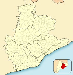
Martorell
Appearance
Martorell | |
|---|---|
 | |
| Coordinates: 41°28′37″N 1°55′41″E / 41.477°N 1.928°E | |
| Country | |
| Community | |
| Province | Barcelona |
| Comarca | Baix Llobregat |
| Government | |
| • Mayor | Xavier Fonollosa (Junts per Martorell)[1] |
| Area | |
| • Total | 12.8 km2 (4.9 sq mi) |
| Elevation | 56 m (184 ft) |
| Population (2018)[3] | |
| • Total | 27,850 |
| • Density | 2,200/km2 (5,600/sq mi) |
| Website | martorell |
Martorell (Catalan pronunciation: [məɾtuˈɾeʎ]) is a municipality, county, and city that forms part of the Baix Llobregat comarca, in Catalonia, Spain, primarily known for its medieval Devil's bridge.[4] It lies at the confluence of the Llobregat and Anoia rivers.
It has three railway stations - one on the Renfe line from Manresa to Sant Vicenç de Calders (via Barcelona and Vilafranca del Penedès) called "Martorell", and three on the FGC line from Barcelona to Manresa called "Martorell-Vila", "Martorell-Enllaç" and "Martorell-Central".
Martorell is home to the SEAT corporate headquarters[5] and automobile factory,[6] where the SEAT Ibiza, Leon, Arona and Audi A1 are manufactured.
Demography
| 1900 | 1930 | 1950 | 1970 | 1986 | 2002 | 2013 |
|---|---|---|---|---|---|---|
| 3221 | 4972 | 5887 | 13,086 | 16,170 | 24,549 | 28,108 |
Climate
| Climate data for Martorell (data from 1964-1970) | |||||||||||||
|---|---|---|---|---|---|---|---|---|---|---|---|---|---|
| Month | Jan | Feb | Mar | Apr | May | Jun | Jul | Aug | Sep | Oct | Nov | Dec | Year |
| Mean daily maximum °C (°F) | 11.6 (52.9) |
12.8 (55.0) |
16.3 (61.3) |
20.7 (69.3) |
25.8 (78.4) |
29.5 (85.1) |
33.0 (91.4) |
31.3 (88.3) |
26.3 (79.3) |
21.2 (70.2) |
15.0 (59.0) |
10.8 (51.4) |
21.2 (70.2) |
| Daily mean °C (°F) | 6.8 (44.2) |
7.6 (45.7) |
10.4 (50.7) |
14.1 (57.4) |
18.4 (65.1) |
21.9 (71.4) |
25.4 (77.7) |
24.8 (76.6) |
20.8 (69.4) |
16.2 (61.2) |
10.2 (50.4) |
6.6 (43.9) |
15.3 (59.5) |
| Mean daily minimum °C (°F) | 2.1 (35.8) |
2.4 (36.3) |
4.6 (40.3) |
7.5 (45.5) |
11.1 (52.0) |
14.3 (57.7) |
17.9 (64.2) |
18.4 (65.1) |
15.4 (59.7) |
11.1 (52.0) |
5.5 (41.9) |
2.5 (36.5) |
9.4 (48.9) |
| Source: Sistema de Clasificación Bioclimática Mundial[7] | |||||||||||||
References
- ^ "Ajuntament de Martorell". Generalitat of Catalonia. Retrieved 2015-11-13.
- ^ "El municipi en xifres: Martorell". Statistical Institute of Catalonia. Retrieved 2015-11-23.
- ^ Municipal Register of Spain 2018. National Statistics Institute.
- ^ "We have sold our soul to the devil!: Devil's bridge in Catalunya - LiveCatalunya". LiveCatalunya. 2014-10-21. Retrieved 2017-09-26.
- ^ "Legal Note Archived 2015-02-06 at the Wayback Machine." SEAT. Retrieved on 20 November 2012. "Autovía A-2, Km 585 – 08760 Martorell"
- ^ Goodman, Peter S. (2017-07-31). "Spain's economy is bouncing back | TheRecord.com". TheRecord.com. Retrieved 2017-09-26.
- ^ "ESP BARCELONA - MARTORELL".
- Panareda Clopés, Josep Maria; Rios Calvet, Jaume; Rabella Vives, Josep Maria (1989). Guia de Catalunya, Barcelona: Caixa de Catalunya. ISBN 84-87135-01-3 (Spanish). ISBN 84-87135-02-1 (Catalan).
External links
Wikimedia Commons has media related to Martorell.
- Government data pages (in Catalan)
| Autoritat del Transport Metropolità Ferrocarrils de la Generalitat de Catalunya | ||||
|---|---|---|---|---|
| Line R6 | ||||
| Barcelona (Plaça d'Espanya) |
↔ | Martorell-Enllaç | ↔ | Igualada |


