
Marlik


Marlik is an ancient site near Roudbar in Gilan, in northern Iran. Marlik, also known as Cheragh-Ali Tepe[1] is located in the valley of Gohar Rud (gem river), a tributary of Sepid Rud in Gilan Province in Northern Iran, Marlik. Marlik is the site of a royal cemetery, and artifacts found at this site date back to 3,000 years ago. Some of the artifacts contain amazing workmanship with gold.[2] Marlik is named after the Amard people.
Marlik Cup
Marlik Cup is a cup of pure gold and is 18 cm high. The height of the prominent designs of the cup reaches 2 cm.[citation needed]

Archaeology
The mound at Mārlik is a rocky outcrop capped by several meters of sediment. It is surrounded by olive groves and fruit gardens owned and maintained by local villagers, overlooking rice paddies on the lower slopes of the valley. The site was already partly looted by treasure hunters and the archaeology team were hindered by local corruption[1][3]
A number of tombs were found. The initial Archaeology report concluded: "In total, fifty-three tombs were discovered at Mārlik. The tombs were dug into the overlaying sediments of the mound, sometimes hitting and penetrating into the underlying bedrock. The tomb constructions vary from roughly dug pits lined with stone to fairly well-constructed examples with walls made from stone slabs bound together with mud mortar. The stone used in the tombs is mostly local, but in some tombs one could see yellowish slabs brought from the headwaters of the Gowharrud, some 15 km to the south. A few, evidently more important, tombs are entirely made of this imported stone, a potential indication to the social significance of the occupant. The tombs range in size from fairly small (1.5x1x1 m [Tomb 4]) to relatively large (7x4.5x2.5 m [Tomb 52]). Most tombs yielded very little or no large skeletal remains, perhaps a result of natural deterioration of organic material and rodent activity. In the handful of tombs, where partial skeletal remains where preserved, the body seemed to have been laid on its side on a large, flattened slab, surrounded by grave goods."
The archaeology is generally assumed to have belonged to a people group who spoke an Iranian language and who migrated into Iran from Central Asia in early to mid-2nd millennium BCE. The abundance of arms, horse-trappings (as well as horse burials), and spouted vessels among the grave goods has been cited as distinct Iranian signatures (Kurochkin). The exact attribution of these people, however, remains largely a conjecture.[4]
See also
Gallery
-

-
 Silver cup with a decorative edge of a sheep, 14th to 11th century BC. Place of discovery of Marlik Hill Cemetery, Louvre
 -
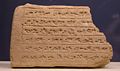 A piece of brick with inscriptions in cuneiform Elamite (circa 1000 BC) discovered on Marlik Hill, Rosicrucian Egyptian Museum, San Jose, California
 -
 A clay bowl discovered on Marlik Hill, Egyptian Rosicrucian Museum, San Jose, California. This type of bowl could contain the ration of a day laborer who was forced to work.
 -
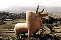 Cow-shaped earthenware
 -
 Animal vase, National Museum of Oriental Art, Rome
 -
 Bronze Bracelet,
 -
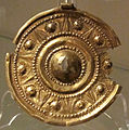 Disc-like necklace, National Museum of Oriental Art, Rome


References
- ^ a b D. Josiya Negahban, Marlik.
- ^ Langer, William L., ed. (1972). An Encyclopedia of World History (5th ed.). Boston, MA: Houghton Mifflin Company. pp. 17. ISBN 0-395-13592-3.
- ^ Marlik : the complete excavation report: Archaeological report(University Museum, University of Pennsylvania, 1994) p15-24.
- ^ ʿE.-A. Negahbān, “The Wonderful Gold Treasure of Marlik,” Illustrated London News, 28 April 1962, pp. 663-64.
- G.N. Kurochkin, "Archeological search for the Near Eastern Aryans and the royal cemetery of Marlik in northern Iran", nnales Academiae Scientiarum Fennicae. Series B ISSN 0066-2011, 1993, vol. 271 (1), pp. 389–395 (10 ref.)[1] [dead link]
- Negahban, Ezat O. (1996). Marlik: The Complete Excavation Report. UPenn Museum of Archaeology. ISBN 9780924171321. Retrieved 25 June 2012.
36°49′50″N 49°27′33″E / 36.83056°N 49.45917°E
| Capital |  | |
|---|---|---|
| Counties and cities | ||
| Sights |
| |
| Populated places | ||