
Marcali
Marcali | |
|---|---|
 The Roman Catholic Church of Marcali | |
 Flag  Coat of arms | |
 Marcali Location of Marcali | |
| Coordinates: 46°35′09″N 17°24′46″E / 46.58582°N 17.41279°E | |
| Country | |
| Region | Southern Transdanubia |
| County | Somogy |
| District | Marcali |
| RC Diocese | Kaposvár |
| Area | |
| • Total | 101.5 km2 (39.2 sq mi) |
| Population (2017) | |
| • Total | 11,216[1] |
| Demonym | marcali |
| Time zone | UTC+1 (CET) |
| • Summer (DST) | UTC+2 (CEST) |
| Postal code | 8700 |
| Area code | (+36) 85 |
| Patron Saint | Holy Mary |
| NUTS 3 code | HU232 |
| MP | József Attila Móring (KDNP) |
| Website | marcali.hu |
Marcali (German: Martzal) is a town in Somogy County, Hungary, and the seat of Marcali District.
The settlement is part of the Balatonboglár wine region.[2]
Geography
It lies 14 km south of Lake Balaton, next to the main road 68 and the Somogyszob-Balatonszentgyörgy Railway Line.
Media
Near the village Kisperjés, which belongs to Marcali, there is at 46°36′53.5″N 17°27′53.63″E / 46.614861°N 17.4648972°E a mediumwave broadcasting station with a 126 metres tall guyed mast radiator broadcasting on 1188 kHz with 300 kW.
Notable people
- Aurél Bernáth (1895–1982), painter and art theorist
- Béla Pap de Szill (1845–1916), military officer, politician, Minister of Defence (1906)
- Endre Bán (1934–1995), Roman Catholic priest, theologist and professor
- Mya Diamond (born 1981), pornographic actress and nude model
- Árpád Milinte (born 1976), footballer
- Olivér Kovács (born 1990), footballer
- Márta Vass (born 1962), ultramarathon runner
- Beatrix Balogh (born 1974), handballer
- Béla Virág (born 1976), footballer
- Lukács Bőle (born 1990), footballer
- Zoltán Farkas (born 1989), footballer
Twin towns – sister cities
 Künzelsau, Germany
 Medulin, Croatia
 Morrovalle, Italy
 Toplița, Romania
Gallery
-
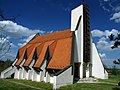 Gisella Church
 -
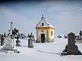 Chapel in the Boronka Cemetery
 -
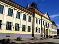
 The building of the music school (built in 1898)
 -
 Gáspár Noszlopy Primary School
 -
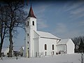 Saint Barbara Church of Boronka


References
- ^ Marcali, KSH
- ^ A Balatonboglári borvidék hegyközségi tanácsának alapszabálya (PDF)
- ^ "Testvérvárosok". marcali.hu (in Hungarian). Marcali. Retrieved 2021-04-10.
External links
Wikimedia Commons has media related to Marcali.
- Official website (in Hungarian)
- Street map (in Hungarian)
- Marcali Portal (in Hungarian)


| International | |
|---|---|
| National | |
| Geographic | |
This Somogy county location article is a stub. You can help Wikipedia by expanding it. |