
Longfellow Peak
| Longfellow Peak | |
|---|---|
 | |
| Highest point | |
| Elevation | 8,904 ft (2,714 m)[1] |
| Prominence | 2,744 ft (836 m)[1] |
| Coordinates | 48°44′44″N 113°56′21″W / 48.74556°N 113.93917°W[2] |
| Naming | |
| Etymology | Henry Wadsworth Longfellow |
| Geography | |
 Longfellow Peak Location in Montana  Longfellow Peak Location in the United States | |
| Location | Flathead County, Montana, U.S. |
| Parent range | Livingston Range |
| Topo map | USGS Camas Ridge East, MT |
Longfellow Peak (8,904 feet (2,714 m)) is located in the Livingston Range, Glacier National Park in the U.S. state of Montana. Longfellow Peak is immediately north of Paul Bunyans Cabin, a rock formation that resembles a log cabin from a distance.[3] Lake Evangeline is northeast of the peak and Ruger Lake is to the east. The mountain was named by R. H. Sargent, topographer for the US Geological Survey in the early mapping of Glacier Park, to honor the American poet Henry Wadsworth Longfellow, (1807–1882).[4]
Climate
Based on the Köppen climate classification, Longfellow Peak is located in a subarctic climate characterized by long, usually very cold winters, and short, cool to mild summers.[5] Temperatures can drop below −10 °F with wind chill factors below −30 °F.
See also
Gallery
-
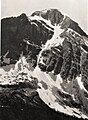 South aspect in 1913
 -
 Longfellow Peak aerial of southeast aspect, circa 1925
 -
 Heavens Peak (left) and Longfellow Peak (right) seen from the northeast.


References
- ^ a b "Longfellow Peak, Montana". Peakbagger.com. Retrieved 2010-08-08.
- ^ "Longfellow Peak". Geographic Names Information System. United States Geological Survey, United States Department of the Interior. Retrieved 2010-08-08.
- ^ Longfellow Peak, MT (Map). TopoQwest (United States Geological Survey Maps). Retrieved January 7, 2019.
- ^ Through The Years In Glacier National Park An Administrative History, NPS.gov
- ^ Peel, M. C.; Finlayson, B. L. & McMahon, T. A. (2007). "Updated world map of the Köppen−Geiger climate classification". Hydrol. Earth Syst. Sci. 11: 1633–1644. ISSN 1027-5606.
This Flathead County, Montana state location article is a stub. You can help Wikipedia by expanding it. |