
Lanta, Haute-Garonne
Lanta | |
|---|---|
 The town hall in Lanta | |
.svg) Coat of arms | |
Location of Lanta  | |
 Lanta  Lanta | |
| Coordinates: 43°33′37″N 1°39′20″E / 43.5603°N 1.6556°E | |
| Country | France |
| Region | Occitania |
| Department | Haute-Garonne |
| Arrondissement | Toulouse |
| Canton | Revel |
| Government | |
| • Mayor (2022–2026) | Rémi Diaz[1] |
| Area 1 | 30.12 km2 (11.63 sq mi) |
| Population (2021)[2] | 2,220 |
| • Density | 74/km2 (190/sq mi) |
| Time zone | UTC+01:00 (CET) |
| • Summer (DST) | UTC+02:00 (CEST) |
| INSEE/Postal code | 31271 /31570 |
| Elevation | 159–275 m (522–902 ft) (avg. 230 m or 750 ft) |
| 1 French Land Register data, which excludes lakes, ponds, glaciers > 1 km2 (0.386 sq mi or 247 acres) and river estuaries. | |
Lanta (French pronunciation: [lɑ̃ta]; Occitan: Lantar) is a commune in the Haute-Garonne department in southwestern France.
History
The attempt of the capitoul Pierre Hunault, sieur de Lanta, to seize control of Toulouse's Capitol was the immediate cause of the 1562 riots there.
Population
| Year | Pop. | ±% p.a. |
|---|---|---|
| 1968 | 874 | — |
| 1975 | 908 | +0.55% |
| 1982 | 1,026 | +1.76% |
| 1990 | 1,144 | +1.37% |
| 1999 | 1,175 | +0.30% |
| 2007 | 1,483 | +2.95% |
| 2012 | 1,775 | +3.66% |
| 2017 | 2,070 | +3.12% |
| Source: INSEE[3] | ||
Monument
-
 The bell gable
 -
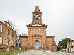 The Church of Our Lady of Lanta
 -
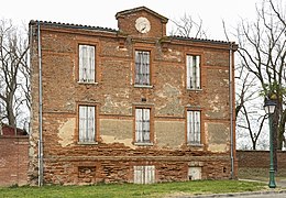 The facade of the old rectory.
 -
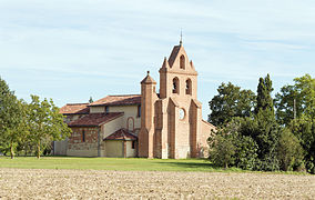 Lanta - Saint Anatoly
 -
 Saint Anatoly de Lanta
 -
 Dovecote.


See also
References
- ^ "Répertoire national des élus: les maires" (in French). data.gouv.fr, Plateforme ouverte des données publiques françaises. 6 June 2023.
- ^ "Populations légales 2021". The National Institute of Statistics and Economic Studies. 28 December 2023.
- ^ Population en historique depuis 1968, INSEE
Wikimedia Commons has media related to Lanta.
This Haute-Garonne geographical article is a stub. You can help Wikipedia by expanding it. |