
Hutton-le-Hole
| Hutton-le-Hole | |
|---|---|
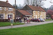
 The village green, Hutton-le-Hole | |
.svg) Hutton-le-Hole Location within North Yorkshire | |
| Population | 151 (2011 census)[1] |
| OS grid reference | SE705900 |
| Civil parish |
|
| Unitary authority | |
| Ceremonial county | |
| Region | |
| Country | England |
| Sovereign state | United Kingdom |
| Post town | YORK |
| Postcode district | YO62 |
| Police | North Yorkshire |
| Fire | North Yorkshire |
| Ambulance | Yorkshire |
| UK Parliament | |
Hutton-le-Hole is a small village and civil parish in North Yorkshire, England, about 7 miles (11 km) north-west of Pickering. It is a popular scenic village within the North York Moors National Park. Sheep roam the streets at will.
History
The village appears in the Domesday Book of 1086 as Hoton.[2] Since then it has been known as Hege-Hoton, Hoton under Heg and Hewton. The name Hutton-le-Hole means place of the burial ground near the hollow,[3] but the full name appears only in the 19th century.[4]
Near the end of the 13th century, the village was granted to St Mary's Abbey, York.[5]
In the 1600s the village was mainly inhabited by Quakers working as weavers or in agriculture.[6] The Quaker evangelist John Richardson died there in 1753 at the age of 87.[7] About four miles away in Kirbymoorside stands an old building that began as a Quaker Meeting House in 1690; it was much modified in 1790 and extended about 1810.[8] It remains a Grade II listed building.[9] John Richardson was buried at the Meeting's burial site.[10] There was a Meeting House in Hutton-le-Hole as well, built in 1698 but turned into a residence in 1859. Interments there continued until 1868.[11]


By 1831, Hutton-le-Hole was part of the Anglican Lastingham parish. The "Township of Hutton-le-Hole" was receiving education funding from a charity owned by John Stockton in 1914.[12] The first schoolhouse was built in 1845 and replaced in 1875 by a Grade II listed building, but this is now a holiday let.[13][14]
In 1901, the old building of the Zion Chapel still stood, but was no longer in use. The village bought it and pulled it down in 1934 when a new church, St Chad's, was built; this still stands and forms part of the Benefice of Lastingham. In earlier years, services had been held in the schoolhouse.[15]
Altogether the village has 29 properties historically listed as Grade II, many of them from the 18th century.[16] One is a K6 telephone kiosk designed in 1935, another a sundial installed in 1833.[17]
The world championships in the board game Nine men's morris took place annually at the Ryedale Folk Museum in Hutton-le-Hole until 1997.[18]
Tourism
In the Victorian period, gentry saw village as "ill-planned and untidy" and "overcrowded [with] homes of weavers, smallholders and labourers.... Manure was piled everywhere and the beck was the common sewer."[19]
Hutton-le-Hole now features among the "20 most beautiful villages in the UK and Ireland" according to Condé Nast Traveler and is much visited.[20] It has a large pay-and-display car park at the north end.[21] The National Park Authority recommends visits to the Hutton le Hole Craft Workshops and Ryedale Folk Museum, followed by a two-mile walk to Lastingham and its ancient church, St Mary's.[22]
The museum covers 13 rescued and reconstructed historic buildings, including an Iron Age round house, period shops, thatched cottages, an Elizabethan manor house, barns and workshops, to display the lives of ordinary people up to the present day. There is a cafe, a shop, a gift shop, and in season craft workshops.[23] The folk museum also has the photographic studio of William Hayes, believed to be the oldest daylight photographic studio in England, set up in the early 20th century.[24] The studio was built in 1902 in Monkgate, York, and donated to the museum in 1991.[25]
Geography

Hutton-le-Hole lies in Ryedale on the southern edge of the North York Moors, just 2.5 miles (4 km) north of Kirkbymoorside and the A170 road.[26] The hamlet of Lastingham is 1.5 miles (2.4 km) north-east of the village,[27] with the Tabular Hills Walk passing through both places.[28]
The stream Hutton Beck wends its way through the middle of the village, criss-crossed by footpaths and wooden bridges.[29] One of the bridges was replaced in 2002 by the North York Moors National Park Authority when pedestrian traffic across increased dramatically, after the village green was designated as a right of way.[30] The stream splits the village green, whose grass is kept short by sheep.[31] Hutton Beck flows into the River Rye via Catter Beck and the River Seven.[32]
Gallery
-
 Image along Fairy Call beck
 -
 Dwellings on the village green and beck
 -
 On the village green and beck
 -
 Shops in Hutton-le-Hole
 -
 Snow in 2021
 -
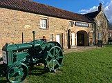 Outside Ryedale Folk Museum
 -
 Hutton-le-Hole and Hutton Beck


References
- ^ UK Census (2011). "Local Area Report – Hutton-le-Hole Parish (1170217256)". Nomis. Office for National Statistics. Retrieved 16 November 2018.
- ^ Powell-Smith, Anna. "Hutton [le Hole] | Domesday Book". opendomesday.org. Retrieved 16 November 2018.
- ^ Chrystal, Paul (2017). The Place Names of Yorkshire; Cities, Towns, Villages, Rivers and Dales, some Pubs too, in Praise of Yorkshire Ales (1 ed.). Catrine: Stenlake. p. 47. ISBN 9781840337532.
- ^ Dillon, Paddy (2016). The Cleveland Way and the Yorkshire Wolds Way (2 ed.). Milnthorpe: Cicerone. p. 105. ISBN 978-1-85284-823-1.
- ^ "Parishes: Lastingham, Pages 524-529, A History of the County of York North Riding: Volume 1". Retrieved 14 March 2021.
- ^ "HUTTON LE HOLE". Retrieved 14 March 2021.
- ^ Gerona, Carla (23 September 2004). "Richardson, John (1667–1753)". Oxford Dictionary of National Biography (online ed.). Oxford University Press. doi:10.1093/ref:odnb/23561. Retrieved 16 November 2018. (Subscription or UK public library membership required.)
- ^ "Friends Meeting House, Kirkbymoorside" (PDF). Retrieved 14 March 2021.
- ^ "FRIENDS MEETING HOUSE AT REAR OF 79 (West End)". Retrieved 14 March 2021.
- ^ "Kirkbymoorside". Archived from the original on 27 October 2016. Retrieved 14 March 2021.
- ^ "QUAKER PROPERTIES AROUND RYEDALE" (PDF). Retrieved 14 March 2021.
- ^ "Parishes: Lastingham, Pages 524-529, A History of the County of York North Riding: Volume 1". Retrieved 14 March 2021.
- ^ "HUTTON LE HOLE". Retrieved 14 March 2021.
- ^ "Hutton le Hole Holiday Cottages North York Moors, North Yorkshire, Go Yorkshire". 30 November 2020. Retrieved 14 March 2021.
- ^ "Hutton-le-Hole, St Chad's Church". 18 November 2010. Retrieved 14 March 2021.
- ^ "11 Unique Market Towns And Villages In The North York Moors". Retrieved 14 March 2021.
- ^ "Listed Buildings in Hutton-le-Hole, Ryedale, North Yorkshire". Retrieved 14 March 2021.
- ^ "Merrills history". 3 December 2009. Archived from the original on 4 March 2016. Retrieved 7 March 2013.
- ^ "Hutton le Hole and Lastingham". Retrieved 14 March 2021.
- ^ "THE 20 MOST BEAUTIFUL VILLAGES IN THE UK AND IRELAND, 20 October 2020". 20 October 2020. Retrieved 14 March 2021.
- ^ "Car Parks and Toilets". Retrieved 14 March 2021.
- ^ "Hutton le Hole and Lastingham". Retrieved 14 March 2021.
- ^ "Ryedale on the Net". Retrieved 17 February 2016.
- ^ "Snapshot of the past in historic photo studio". The Yorkshire Post. 22 September 2014. Retrieved 16 November 2018.
- ^ "TAKING A PHOTOGRAPH THE EDWARDIAN WAY". Retrieved 14 March 2021.
- ^ "OL26" (Map). North York Moors – Western area. 1:25,000. Explorer. Ordnance Survey. 2016. ISBN 978-0319242650.
- ^ "Genuki: In 1822, the following places were in the Parish of Lastingham:, Yorkshire (North Riding)". www.genuki.org.uk. Retrieved 16 November 2018.
- ^ Dillon, Paddy (2016). The Cleveland Way and the Yorkshire Wolds Way (2 ed.). Milnthorpe: Cicerone. p. 5. ISBN 978-1-85284-823-1.
- ^ Andrews, Robert; Brown, Jules; Lee, Phil; Humphreys, Rob (2011). The rough guide to England (9 ed.). London: Rough Guides. p. 753. ISBN 978-1-84836-601-5.
- ^ "Popular bridge replaced". The Northern Echo. 5 August 2002. ProQuest 329042225.
- ^ "Hutton le Hole and Lastingham: North York Moors National Park". northyorkmoors.org.uk. Retrieved 16 November 2018.
- ^ "Catter Beck/Hutton Beck from source to River Seven". environment.data.gov.uk. Retrieved 16 November 2018.
External links
 Media related to Hutton-le-Hole at Wikimedia Commons
- Hutton-le-Hole