
Greenville, Georgia
Greenville, Georgia | |
|---|---|
 The Greenville Historic District was added to the National Register of Historic Places on March 16, 1990. | |
 Location in Meriwether County and the state of Georgia | |
| Coordinates: 33°1′40″N 84°42′49″W / 33.02778°N 84.71361°W | |
| Country | United States |
| State | Georgia |
| County | Meriwether |
| Area | |
• Total | 2.36 sq mi (6.11 km2) |
| • Land | 2.34 sq mi (6.07 km2) |
| • Water | 0.01 sq mi (0.04 km2) |
| Elevation | 869 ft (265 m) |
| Population | |
• Total | 794 |
| • Density | 338.74/sq mi (130.78/km2) |
| Time zone | UTC-5 (Eastern (EST)) |
| • Summer (DST) | UTC-4 (EDT) |
| ZIP code | 30222 |
| Area code | 706 |
| FIPS code | 13-35016[3] |
| GNIS feature ID | 0356105[4] |
| Website | cityofgreenvillega.com |
Greenville is a city and the county seat of Meriwether County, Georgia, United States.[5] The population was 794 at the 2020 census,[2] down from 876 in 2010. The city is located 60 miles (97 km) southwest of Atlanta and is part of the Atlanta metropolitan area (Atlanta-Sandy Springs-Marietta, Georgia Metropolitan Statistical Area).
History
Greenville was founded in 1828 as the seat of the newly formed Meriwether County.[6] The city was named for Major General Nathanael Greene, commander of the rebel American forces at the Battle of Guilford Court House on March 15, 1781.[7]
Geography
Greenville is located in central Meriwether County at 33°1′40″N 84°42′49″W / 33.02778°N 84.71361°W (33.027845, -84.713562).[8] U.S. Route 27 Alternate and Georgia State Routes 109 and 100 intersect in the center of the city at the county courthouse. US 27 Alternate leads north 25 miles (40 km) to Newnan and south 49 miles (79 km) to Columbus, while State Route 109 leads southeast 8 miles (13 km) to Woodbury and west 20 miles (32 km) to LaGrange. State Route 100 leads northwest 16 miles (26 km) to Hogansville.
According to the United States Census Bureau, the city has a total area of 2.4 square miles (6.2 km2), of which 0.01 square miles (0.03 km2), or 0.59%, are water.[1] The city drains to the south into Walnut Creek and to the east into Kennel Creek, a tributary. Walnut Creek is an east-flowing tributary of Red Oak Creek and part of the Flint River watershed.
Demographics
| Census | Pop. | Note | %± |
|---|---|---|---|
| 1880 | 490 | — | |
| 1900 | 815 | — | |
| 1910 | 909 | 11.5% | |
| 1920 | 760 | −16.4% | |
| 1930 | 672 | −11.6% | |
| 1940 | 683 | 1.6% | |
| 1950 | 733 | 7.3% | |
| 1960 | 726 | −1.0% | |
| 1970 | 1,085 | 49.4% | |
| 1980 | 1,213 | 11.8% | |
| 1990 | 1,167 | −3.8% | |
| 2000 | 946 | −18.9% | |
| 2010 | 876 | −7.4% | |
| 2020 | 794 | −9.4% | |
| U.S. Decennial Census[9] | |||
| Race | Num. | Perc. |
|---|---|---|
| White (non-Hispanic) | 288 | 36.27% |
| Black or African American (non-Hispanic) | 473 | 59.57% |
| Other/Mixed | 24 | 3.02% |
| Hispanic or Latino | 9 | 1.13% |
As of the 2020 United States census, there were 794 people, 368 households, and 219 families residing in the city.
Education
Meriwether County School District
The Meriwether County School District holds pre-school to grade twelve, and consists of three elementary schools, two middle schools, and two high schools.[11] The district has 300 full-time teachers and over 3,948 students.[12]
- George E. Washington Elementary School
- Mountain View Elementary School
- Unity Elementary School
- Greenville Middle School
- Manchester Middle School
- Greenville High School
- Manchester High School
Notable people
- Mario Alford, wide receiver for the Cincinnati Bengals of the NFL
- Kentavious Caldwell-Pope, 2013 SEC Player of the Year, eighth overall selection in the 2013 NBA draft by the Detroit Pistons and 2x NBA champion.
- Lella A. Dillard, president, Georgia Woman's Christian Temperance Union
- Y. Frank Freeman, executive with Paramount Pictures
- Clara Ann Howard, Baptist missionary in Africa, longtime staff member at Spelman College
- William J. Samford, 31st governor of Alabama
- Joseph M. Terrell, 57th governor of Georgia (October 25, 1902 – June 29, 1907); from Greenville, buried in the local cemetery
- Hiram Warner, one of the original members of the Supreme Court of Georgia, eventually becoming that court's second chief justice. Warner also held office as a circuit court judge, a representative in the Georgia General Assembly, and a U.S. congressman.
- Jontavious Willis, country blues singer, guitarist, songwriter, and multi-instrumentalist[13]
Gallery
-
 The Meriwether County Courthouse is located in Greenville, the county seat.
 -

-
 Greenville Post Office (ZIP code: 30222)
 -
 The Meriwether County Jail was built in 1896 and added to the National Register of Historic Places on May 7, 1973.
 -
 The Greenville Presbyterian Church and Cemetery was added to the National Register of Historic Places on February 5, 2002.
 -
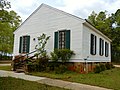
 The Harman-Watson-Matthews House was added to the National Register of Historic Places on May 9, 1973.
 -
 The Burwell O. Hill House was added to the National Register of Historic Places on June 17, 1982.
 -
 The Hiram Warner Hill House was added to the National Register of Historic Places on April 7, 1983.
 -
 The Render Family Homestead was added to the National Register of Historic Places on March 1, 1984.
 -
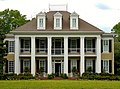
 Twin Oaks, also known as Winsor Hall, was added to the National Register of Historic Places on August 26, 1980.


References
- ^ a b "2022 U.S. Gazetteer Files: Georgia". United States Census Bureau. Retrieved January 24, 2023.
- ^ a b "P1. Race – Greenville city, Georgia: 2020 DEC Redistricting Data (PL 94-171)". U.S. Census Bureau. Retrieved January 24, 2023.
- ^ "U.S. Census website". United States Census Bureau. Retrieved January 31, 2008.
- ^ "US Board on Geographic Names". United States Geological Survey. October 25, 2007. Retrieved January 31, 2008.
- ^ "Find a County". National Association of Counties. Archived from the original on May 31, 2011. Retrieved June 7, 2011.
- ^ Hellmann, Paul T. (May 13, 2013). Historical Gazetteer of the United States. Routledge. p. 232. ISBN 978-1135948597. Retrieved November 30, 2013.
- ^ Krakow, Kenneth K. (1975). Georgia Place-Names: Their History and Origins (PDF). Macon, GA: Winship Press. p. 98. ISBN 0-915430-00-2.
- ^ "US Gazetteer files: 2010, 2000, and 1990". United States Census Bureau. February 12, 2011. Retrieved April 23, 2011.
- ^ "Census of Population and Housing". Census.gov. Retrieved June 4, 2015.
- ^ "Explore Census Data". data.census.gov. Retrieved December 14, 2021.
- ^ [1][permanent dead link]
- ^ Meriwether County school data. Archived from the original on 2012-03-23. Retrieved on 2023-03-01.
- ^ "Bio". Jontaviouswillis.com. Retrieved July 23, 2019.
Municipalities and communities of Meriwether County, Georgia, United States | ||
|---|---|---|
| Cities | 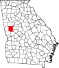 | |
| Towns | ||
| Unincorporated communities | ||
| Footnotes | ‡This populated place also has portions in an adjacent county or counties | |
| Authority control databases: Geographic |
|---|