
Gosh, Armenia
Gosh
Գոշ | |
|---|---|
 A view of Gosh | |
 Coat of arms | |
 Gosh Location in Armenia  Gosh Gosh (Tavush) | |
| Coordinates: 40°43′45″N 44°59′50″E / 40.72917°N 44.99722°E | |
| Country | Armenia |
| Province | Tavush |
| Municipality | Dilijan |
| Population | |
| • Total | 1,115 |
| Time zone | UTC+4 (AMT) |
| Gosh, Armenia at GEOnet Names Server | |
Gosh (Armenian: Գոշ) is a village in the Dilijan Municipality of the Tavush Province of Armenia.
The village is named after Mkhitar Gosh (1130–1213) who took part in the rebuilding of the Nor Ghetik Monastery during the 12th-13th centuries, which was destroyed by an earthquake in 1188. The newly built monastery was later named Goshavank in honor of Mkhitar.
Goshavank is located just off the main highway that runs through the village. On a hillside west of the monastery complex sits a chapel that also serves as the tomb of Mkhitar Gosh. It was situated to overlook the monastery in which he helped build. The chapel is square in plan with a single centrally located dome above and one portal. Nearby are the ruins of what is said to be Mkhitar's house. Stone foundations and low walls still exist.
Gallery
-
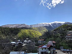 A view of the village
 -
 Goshavank, August 2009
 -
 St. George's Church (Mkhitar Gosh's funeral chapel)
 -
 Gosh lake
 -
 Goshavank interior
 -
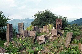 The ruins of Mikhtar Gosh's house


References
External links
- World Gazeteer: Armenia[dead link] – World-Gazetteer.com
- Report of the results of the 2001 Armenian Census, Statistical Committee of Armenia
- Gosh at Armeniapedia.org
- Virtualarmenia.am
Capital: Ijevan | ||
| Urban settlements |  | |
| Berd Municipality | ||
| Dilijan Municipality | ||
| Ijevan Municipality | ||
| Noyemberyan Municipality | ||
This article about a location in Tavush Province, Armenia is a stub. You can help Wikipedia by expanding it. |