
Gorey, Jersey
Gorey | |
|---|---|
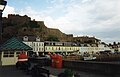
 A view of Gorey from Mont Orgueil | |
 Map of Jersey zoomed on Gorey. | |
| Crown Dependency | Jersey, Channel Islands |
| Time zone | GMT |
| • Summer (DST) | UTC+01 |
Gorey (French: Gouray; Jèrriais: Gouôrray) is a village in the parishes of St Martin and Grouville on the east coast of Jersey. The harbour is one of the three main harbours of the island, and is located in St Martin. The main centre of the village is located at Gorey Pier near Mont Orgeuil Castle, a 13th century fortification, in St Martin, while there is a small community with a few shops and restaurants. The church in the village is known as Gouray Church.
History
Its position as the closest strategic mainland point to the Cotentin Peninsula has meant that it has a history of fortification going back at least to the Iron Age. After the division of the Duchy of Normandy in 1204 the strategic location of the harbour led to the construction of the castle of Mont Orgueil to protect the island against the French, also serving as residence for Governors of Jersey until the late 16th century when Elizabeth Castle was constructed off Saint Helier. The castle was anciently called Gouray Castle, but Mont Oreguil is a more recent name (in official use by the late 17th century).[1]
There is a significant oyster bed off the coast of Gorey. In the early 19th century, at least 2,000 men were employed in the industry at Gorey, and a number of cottages were built in the village to accommodate the new English residents. This also led to the construction of Gouray Church to provide English services for the residents (most of the Anglican services on the island at the time were delivered in French).[2]:236
In 2010, it was announced that the Harbour Master's house would be sold, and the proceeds used to carry out restoration work to Gorey Pier.[3] In the same year, plans were submitted for 52 homes on the Jersey Pottery site.[4]
Local economy

The pier below the castle has been the site of the annual Fête de la Mer (seafood gastronomic festival) until 2010,[5] and also contains an interpretation centre exhibiting the history and environment of the area. The annual Gorey Fête in August is one of the largest such events in Jersey.[6]
There are a number of hotels, shops, restaurants, and bars. Many of these facilities are located along the pier, and are used by tourists and locals.
Transport

Gorey Pier is the eastern terminus of the A3 La Rue à Don, which is the main road linking the village to Grouville Church and to St Helier. It was formerly the terminus for the Jersey Eastern Railway.[7]
As part of the Eastern Cycle Network plans, Gorey will be connected to St Helier with a direct off-main road cycle route. A cycle path was constructed along the side of La Rue à Don in Gorey in 2011 in a move to link the village to the local primary school.[8] Later on, the cycle lane was extended south along the Royal Golf Course (at a cost of £190,000)[9] and north to connect to Gorey Pier along the coast.
Notable buildings
Buildings of note in Gorey include Mont Orgueil castle, and Gouray Church, an Anglican church, which serves the village and surrounding district.
Gallery

-
 The castle of Mont Orgueil dominates village and harbour of Gorey
 -
 Another view of Gorey
 -
 Better quality photograph with a view of Gorey
 -
 The pier below the castle contains restaurants, cafés and shops
 -
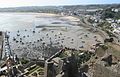
 Gorey Harbour, looking south from the pier across the Royal Bay of Grouville towards La Rocque
 -
 A view across the harbour from the pier at low tide
 -
 Gouray Church can be seen on the hill at left
 -
 A sculptural ensemble commemorates the 19th century shipyards of Gorey
 -
 On 19 January 1945, the harbour was the scene of an escape by two American officers
 -
 A view from Mont Orgueil
 -
 Gorey Village
 -
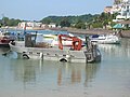 Oyster boat in the harbour at Gorey
 -
 The harbour of Gorey falls dry at low tide
 -
 Church St Martin de Gouray


References
- ^ Poingdestre, Jean (c. 1682). Caesarea. Jersey: Société Jersiaise.
- ^ Syvret, Marguerite (2011). Balleine's History of Jersey. The History Press. ISBN 978-1860776502.
- ^ Proceeds from sale of Harbour Master's House to restore pier
- ^ Homes plan unveiled for Jersey Pottery
- ^ Axed Jersey seafood festival could return
- ^ Gorey Fete in full swing
- ^ "Jersey Eastern Railway - theislandwiki". www.theislandwiki.org. Retrieved 24 February 2018.
- ^ "New cycle path in the east". jerseyeveningpost.com. Retrieved 24 January 2021.
- ^ "Plans unveiled to extend a popular cycle track: Do we need more routes?". jerseyeveningpost.com. Retrieved 24 January 2021.