
Gère
| Gère | |
|---|---|
 The Gère in Vienne | |
  | |
| Location | |
| Country | France |
| Region | Auvergne-Rhône-Alpes |
| Department | Isère |
| Towns | |
| Physical characteristics | |
| Source | Eastern part of the Bonnevaux forest, étang de la Grande Tuilière |
| • location | Châtonnay |
| • coordinates | 45°27′45″N 5°13′12″E / 45.4624°N 5.2201°E |
| • elevation | 549 m |
| Mouth | Rhône |
• location | Vienne |
• coordinates | 45°31′40″N 4°52′24″E / 45.5279°N 4.8734°E |
• elevation | 152 m |
| Length | 34.5 km (21.4 mi) [1] |
| Discharge | |
| • average | 3.15 cubic metres per second (111 cu ft/s) |
| Basin features | |
| Progression | Rhône→ Mediterranean Sea |
The Gère (French pronunciation: [ʒɛʁ]) is a 34.5-kilometre-long (21.4 mi) tributary of the Rhône in the Isère department of Auvergne-Rhône-Alpes (France). Its source is in a pond of the Grand Tuilière in the eastern part of the Bonnevaux forest. It flows into the Rhone at Vienne. Its power was put to work for paper mills, foundries, and textile mills in the Gère Valley at the beginning of the industrial era.[2]
Gallery
-
 The Gère in Estrablin
 -
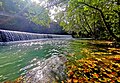 Weir in the Gère Valley (Vienne)
 -
 Railway bridge near the confluence with the Rhône
 -
 The Gère-Rhône confluence


References
- ^ Sandre. "Fiche cours d'eau - La Gère (V32-0400)". Retrieved 6 April 2020.
- ^ "Présentation du patrimoine industriel et de l'habitat de la Vallée de la Gère et du quartier d'Estressin de la ville de Vienne". La Région Auvergne-Rhône-Alpes: Inventaire général du patrimoine culture (in French). Retrieved 6 April 2020.
External links
 Media related to Gère (river) at Wikimedia Commons
- Media related to Vallée de Gère at Wikimedia Commons