Frankivskyi District
This article has multiple issues. Please help improve it or discuss these issues on the talk page. (Learn how and when to remove these template messages)
|
Frankivskyi District
Франківський район | |
|---|---|
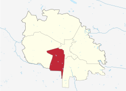
 Map of Lviv and its districts with Frankivskyi highlighted in red. | |
| Country | |
| Oblast | Lviv Oblast |
| Population | |
| • Total | 146,414 |
| Time zone | EET |
Frankívs’kyj District (Ukrainian: Франкі́вський райо́н) is an urban district in the city of Lviv, named after the Ukrainian writer and social activist Ivan Franko. This district covers the southwestern part of the city. It contains such neighborhoods as Vulka, Kastelivka, Novyi Svit and Kulparkiv.
Name
The Frankivs'kyi district is one of the youngest in the city – as a separate administrative unit, it was established on April 15, 1973, and was named the Soviet district of Lviv. However, it received its modern name on February 3, 1993, when the Verkhovna Rada approved its new name – Frankivsk district of Lviv.[1]
See also
49°48′40″N 23°59′49″E / 49.8111°N 23.9969°E
References
- ^ "Про перейменування Радянського району міста Львова". Офіційний вебпортал парламенту України (in Ukrainian). Retrieved 2023-07-03.
