
Franche-Comté
This article needs additional citations for verification. (September 2014) |
Franche-Comté
| |
|---|---|
 Coat of arms | |
| Motto(s): Comtois, rends-toi ! Nenni, ma foi ! Comtois, surrender! No, my faith! | |
 | |
| Coordinates: 47°00′N 6°00′E / 47.000°N 6.000°E | |
| Country | |
| Dissolved | 1 January 2016 |
| Prefecture | Besançon |
| Departments | 4
|
| Area | |
• Total | 16,202 km2 (6,256 sq mi) |
| Population (1 January 2021) | |
• Total | 1,179,601 |
| • Density | 73/km2 (190/sq mi) |
| Demonym | Comtois |
| GDP | |
| • Total | €34.772 billion (2022) |
| • Per capita | €29,500 (2022) |
| Time zone | UTC+1 (CET) |
| • Summer (DST) | UTC+2 (CEST) |
| ISO 3166 code | FR-I |
| NUTS Region | FR43 |
| Website | www.franche-comte.fr (Redirects to www.bourgognefranchecomte.fr) |

Franche-Comté (UK: /ˌfrɒ̃ʃ kɒ̃ˈteɪ/,[2] US: /- koʊnˈ-/;[3][4] French: [fʁɑ̃ʃ kɔ̃te] ; Frainc-Comtou: Fraintche-Comtè; Arpitan: Franche-Comtât; also German: Freigrafschaft; Spanish: Franco Condado; all lit. 'Free County') is a cultural and historical region of eastern France. It is composed of the modern departments of Doubs, Jura, Haute-Saône and the Territoire de Belfort. In 2021, its population was 1,179,601.
From 1956 to 2015, the Franche-Comté was a French administrative region. Since 1 January 2016, it has been part of the new region Bourgogne-Franche-Comté.[5]
The region is named after the Franche Comté de Bourgogne (Free County of Burgundy), definitively separated from the region of Burgundy proper in the fifteenth century. In 2016, these two-halves of the historic Kingdom of Burgundy were reunited, as the region of Bourgogne-Franche-Comté. It is also the 6th biggest region in France. The name "Franche-Comté" is feminine because the word "comté" in the past was generally feminine, although today it is masculine.
The principal cities are the capital Besançon, Belfort and Montbéliard. Other important cities are Dole (the capital before the region was conquered by Louis XIV in the late seventeenth century), Vesoul (capital of Haute-Saône), Arbois (the "wine capital" of the Jura), and Lons-le-Saunier (the capital of Jura).
History
The region has been inhabited since the Paleolithic age and was occupied by the Gauls. It was then heavily settled by Germanic peoples during the Germanic migrations, most notably the Burgundians, who settled in the region after the Gauls had vacated the area. Later, it was part of the territory of the Alemanni in the fifth century, then the Kingdom of Burgundy from 457 to 534. The Burgundians adopted Chalcedonian Christianity, Christianizing the region. In 534, it became part of the Frankish kingdom. In 561 it was included in the Merovingian Kingdom of Burgundy under Guntram, the third son of Clotaire I. In 613, Clotaire II reunited the Frankish Kingdom under his rule, and the region remained a part of the Kingdom of Burgundy under the later Merovingians and Carolingians.
County of Burgundy
The name Franche Comté de Bourgogne or Freigrafschaft Burgund in German (Free County of Burgundy) did not appear officially until 1366. It had been a territory of the County of Burgundy from 888, the province becoming subject to the Holy Roman Empire in 1034. It was definitively separated from the neighboring Duchy of Burgundy upon the latter's incorporation into the Kingdom of France in 1477. That year at the Battle of Nancy during the Burgundian Wars, the last duke, Charles the Bold, was killed in battle. Although the county, along with the Duchy, was seized by King Louis XI of France, in 1492 his son Charles VIII ceded it to Philip of Austria, the grandson and heir of Charles the Bold. When Philip's son, Emperor Charles V, inherited the Spanish throne in 1516, the Franche-Comté, along with the rest of the Burgundian lands (except Burgundy itself), passed to the Spanish.
Province of the Kingdom of France
| Franche-Comté | |||||||||||||
|---|---|---|---|---|---|---|---|---|---|---|---|---|---|
| Government of Kingdom of France | |||||||||||||
| 1668/1674–1790 | |||||||||||||
Coat of arms
| |||||||||||||
.svg) | |||||||||||||
| History | |||||||||||||
• Established | 1668/1674 | ||||||||||||
• Disestablished | 1790 | ||||||||||||
| |||||||||||||
Franche-Comté was captured by France in 1668, but returned to Spain under the Treaty of Aix-la-Chapelle. It was conquered a second time in 1674, and finally was ceded to France in the Treaty of Nijmegen (1678), leaving the Holy Roman Empire as a result. Enclaves such as Montbéliard remained outside French control.

The Franche-Comté was one of the last parts of France to have serfdom. In 1784, half of the population consisted of serfs, accounting for 400,000 out of the 1 million French serfs. Landowners took one-twelfth of the sale's price if a serf (mainmortable) wanted to sell up. Serfs were not forced to stay on the land, but the lord could claim droit de suite, whereby a peasant who died away from his holding left it to the lord, even if he had heirs. A runaway serf's land was forfeit after ten years. Louis XVI issued a decree banning these practices on 8 August 1779, but the Parlement of Besançon blocked this until 1787.
After 1790
The population of the region fell by a fifth from 1851 to 1946, reflecting low French natural growth and migration to more urbanized parts of the country. Most of the decline occurred in Haute-Saône and Jura, which remain among the country's more agriculture-dependent areas.
Environment
This region borders Switzerland and shares much of its architecture, cuisine, and culture with its neighbour. Between the Vosges range of mountains to the north and the Jura range to the south, the landscape consists of rolling cultivated fields, dense pine forest, and rampart-like mountains. Not so majestic as the Alps, the Jura mountains are more accessible and are France's first cross-country skiing area. It is also a superb place to hike, and there are some fine nature trails on the more gentle slopes. The Doubs and Loue valleys, with their timbered houses perched on stilts in the river, and the high valley of Ain, are popular visitor areas. The Région des Lacs is a land of gorges and waterfalls dotted with tiny villages, each with a domed belfry decorated with mosaic of tiles or slates or beaten from metal. The lakes are perfect for swimming in the warmer months. The summits of Haut Jura have wonderful views across Lac Léman (Lake Geneva) and toward the Alps.
Forty percent of the region's GDP is dependent on manufacturing activities, and most of its production is exported. Construction of automobiles and their parts is one of the most buoyant industries there. Forestry exploitation is steadily growing, and 38% of the agriculture is dairy and 17% cattle farming. The region has a large and lucrative cheese-making industry, with 40 million tonnes of cheese produced here each year, much of which is made by fruitières (traditional cheese dairies of Franche-Comté); for instance, Comté cheese comes from this region.
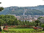
-
 Landscape, Franche-Comté
 -
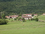
-
 La Petite Montagne, a view from Molard de la Justice
 -


Geology
Principal cities
| City | Metropolitan area | Urban area | Municipality |
|---|---|---|---|
| Besançon | 250,563 | 135,448 | 116,676 |
| Montbéliard | 160,671 | 106,486 | 25,336 |
| Belfort | 114,445 | 81,651 | 49,519 |
| Dole | 65,400 | 29,916 | 23,373 |
| Vesoul | 59,262 | 28,707 | 15,058 |
| Lons-le-Saunier | 58,674 | 26,894 | 17,459 |
| Pontarlier | 30,895 | 21,760 | 17,140 |
| Gray | 17,295 | 9,470 | 5,484 |
| Luxeuil-les-Bains | 14,652 | 12,366 | 6,821 |
| Champagnole | 14,266 | 9,841 | 7,916 |
| Lure | 12,251 | 11,135 | 8,253 |
| Saint-Claude | 11,343 | 10,346 | 9,732 |


Language
Among the regional languages of France, the term Franc-comtois refers to two dialects of two different languages. Franc-comtois is the name of the dialect of Langue d'Oïl spoken by people in the northern part of the region. The dialect of Arpitan has been spoken in its southern part since as early as the thirteenth century (the southern two-thirds of Jura and the southern third of Doubs). Both are recognized as languages of France.
Education
215,178 students were in school in Franche-Comté at the start of the 2018 school year. The region has potential in the research sector. We find in Besançon the National School of Mechanics and Microtechnology (ENSMM) or the UTBM, the University of Technology of Belfort-Montbéliard[6] in Belfort and Montbéliard.
The University of Franche-Comté is mainly located in Besançon. It has 24,000 students spread over six training and research areas (UFR), including five in Besançon and one in Belfort and Montbéliard, two university institutes of technology (IUT) (Besançon-Vesoul and Nord Franche-Comté), 920 students engineers at ENSMM and 2,550 students at UTBM.
People from Franche-Comté
- Raymond Blanc, chef
- Jean-Jacques Boissard, neo-Latin poet
- Paul de Casteljau, mathematician
- Gustave Courbet, painter
- Frank Darabont, filmmaker
- Charles Fourier, philosopher
- Salah Gaham, concierge
- Victor Hugo, poet, playwright, novelist, essayist, visual artist, statesman, human rights activist
- Auguste and Louis Lumière, early filmmakers
- Jean Mairet, dramatist
- Jacques de Molay, last Grandmaster of the Knights Templar
- Charles Nodier, author
- Louis Pasteur, chemist and microbiologist
- Antoine Perrenot de Granvelle, Burgundian statesman, leading minister of the Spanish Habsburgs
- Nicolas Perrenot de Granvelle, minister of justice under Charles V, Holy Roman Emperor
- Pierre-Joseph Proudhon philosopher, socialist
- Jean Baptiste Alexandre Strolz
- Jean-Baptiste-Antoine Suard, journalist
- Hubert-Félix Thiéfaine, singer and songwriter
- Louis Vuitton, designer
- Arnaud Courlet de Vregille, painter
Typical regional products
- Wine: Vin jaune, Arbois
- Cheese: Cancoillotte, Bleu de Gex, Comté, Édel de Cléron, Metton, Morbier, Munster, Vacherin Mont d'Or
- Sausages: Saucisse de Montbéliard, saucisse de Morteau, Gendarme
See also
- Picolaton, imaginary bird of Franche-Comté folklore
References
- ^ "EU regions by GDP, Eurostat". Retrieved 18 September 2023.
- ^ "Franche-Comté". Lexico UK English Dictionary. Oxford University Press.[dead link]
- ^ "Franche-Comté". The American Heritage Dictionary of the English Language (5th ed.). HarperCollins. Retrieved 30 August 2019.
- ^ "Burgundy". Merriam-Webster.com Dictionary. Merriam-Webster. Retrieved 30 August 2019.
- ^ Loi n° 2015-29 du 16 janvier 2015 relative à la délimitation des régions, aux élections régionales et départementales et modifiant le calendrier électoral (in fr)
- ^ Kroichvili, Nathalie, ed. (2023). Actions de revitalisation et territoires en devenir : Le Nord Franche-Comté industriel. Les Cahiers de la MSHE Ledoux (in French). Besançon: Presses universitaires de Franche-Comté. ISBN 978-2-84867-999-0.
External links
- Franche-Comté : land of contrasts - Official French website (in English)
- Conseil régional de Franche-Comté Official website
- Franche-Comté directory search engine
| General governments |
| .svg) |
|---|---|---|
| Minor provinces and regions | ||
| Foreign territories in 1789 | ||
| International | |
|---|---|
| National | |
| Geographic | |
| Other | |