
File:NPS co-canal-map.pdf

Size of this JPG preview of this PDF file: 299 × 598 pixels. Other resolutions: 120 × 240 pixels | 240 × 480 pixels | 384 × 768 pixels | 512 × 1,024 pixels | 2,066 × 4,133 pixels.
Original file (2,066 × 4,133 pixels, file size: 4.48 MB, MIME type: application/pdf)
| This is a file from the Wikimedia Commons. Information from its description page there is shown below. Commons is a freely licensed media file repository. You can help. |
File history
Click on a date/time to view the file as it appeared at that time.
| Date/Time | Thumbnail | Dimensions | User | Comment | |
|---|---|---|---|---|---|
| current | 19:44, 16 May 2017 | 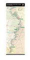 | 2,066 × 4,133 (4.48 MB) | RKBot | =={{int:filedesc}}== {{Information |description= {{en|1=Official Chesapeake and Ohio Canal map from the brochure, showing the entire length from Cumberland, MD to Washington, D.C.}} |date= 2017-05-06 |source= U.S. National Park Service (http://npmaps.c... |
File usage
No pages on the English Wikipedia use this file (pages on other projects are not listed).