
Delaware Mine
 Sign along U.S. 41 | |
| Location | |
|---|---|
 Delaware Mine  Delaware Mine | |
| Location | Delaware |
| State | Michigan |
| Country | United States |
| Coordinates | 47°25′27.47″N 88°5′55.24″W / 47.4242972°N 88.0986778°W |
| Production | |
| Products | Copper |
| Type | Underground |
| Greatest depth | 1,400 ft (430 m) |
| History | |
| Opened | 1847 |
| Closed | 1887 |
The Delaware Mine is located off U.S. Highway 41, 12 miles (19 km) in Grant Township, Keweenaw County, south of Copper Harbor, Michigan and is a Keweenaw Heritage Site.[1][2] The Delaware Copper Mine provides tours of one of the oldest copper mines in the Keweenaw,[2] dating back to 1847. The mine had five shafts, with the deepest reaching 1,400 feet (430 m). The mine is open June through October and offers guided and self-guided tours.[3]
Gallery
-
 Mine entrance
 -
 Delaware Copper Mine Hoist House
 -
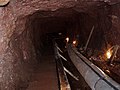 Mine shaft interior
 -
 Delaware Mine shaft interior


References
- ^ "Pure Michigan". Delaware Copper Mine. Retrieved 6 January 2021.
- ^ a b Keweenaw Heritage Sites from the Keweenaw National Historical Park
- ^ "Delaware Copper Mine Tours". Keweenaw Heritage Sites. Retrieved 6 January 2021.
External links
- Delaware Mine - official site
This Michigan museum-related article is a stub. You can help Wikipedia by expanding it. |
This Keweenaw County, Michigan location article is a stub. You can help Wikipedia by expanding it. |
This article about a specific mine is a stub. You can help Wikipedia by expanding it. |