
Degol Woyane
Degol Woyane
Dabba Salama | |
|---|---|
 Dabba Selama monastery on a small mesa in Adigrat Sandstone | |
 Degol Woyane Location within Ethiopia | |
| Coordinates: 13°40′N 39°6′E / 13.667°N 39.100°E | |
| Country | Ethiopia |
| Region | Tigray |
| Zone | Debub Misraqawi (Southeastern) |
| Woreda | Dogu'a Tembien |
| Area | |
| • Total | 29.19 km2 (11.27 sq mi) |
| Elevation | 2,500 m (8,200 ft) |
| Time zone | UTC+3 (EAT) |
Degol Woyane is a tabia or municipality in the Dogu'a Tembien district of the Tigray Region of Ethiopia. It includes Dabba Selama, the oldest monastery of Ethiopia, and the most inaccessible in the world. The tabia centre is in Zala village, located approximately 10 km to the west of the woreda town Hagere Selam.
Geography
The tabia stretches down west of Melfa, along the westernmost ridge of Dogu'a Tembien. The highest peak is T'afa (2580 m a.s.l.) and the lowest place Addi Welo (1990 m a.s.l.).
Geology
From the higher to the lower locations, the following geological formations are present:[1]
Springs
As there are no permanent rivers, the presence of springs is of utmost importance for the local people. The following are the springs in the tabia:[2]
- May Dara in Zala
- Addi Welo
Livelihood
The population lives essentially from crop farming, supplemented with off-season work in nearby towns. The land is dominated by farmlands which are clearly demarcated and are cropped every year. Hence the agricultural system is a permanent upland farming system.[3]
Population
The tabia centre Zala holds a few administrative offices and some small shops. The main other populated places in the tabia are:[4]
|
|
Religion and rock churches
Most inhabitants are Orthodox Christians. The following rock churches are located in the tabia:
The almost inaccessible Dabba Selama monastery (13°41.67′N 39°6.03′E / 13.69450°N 39.10050°E) is assumed to be the first monastery established in Ethiopia, by Saint Frumentius. The intrepid visitor will climb down, then scramble over narrow ledges along precipices, and finally climb an overhanging cliff. The mesa also comprises a church hewn in Adigrat Sandstone, in shape of a small basilica. The carvers attempted to establish four bays as well as with a recess. The pillars are rounded (which is uncommon) and expand at either end, supporting arches that appear as triangles. Women are not allowed to do the ascent, nor to visit monastery or church. Independently from the difficult access to the monastery, the surrounding sandstone geomorphology is unique.[5][6]
The Amani'el church in May Baha (13°40′N 39°5.4′E / 13.667°N 39.0900°E) has also been carved in Adigrat Sandstone. Behind a pronaos (1960s), the rock church has cruciform columns, flat beams and a flat ceiling, a single arch, and a flat rear wall without apse. Windows give light to the church itself. Emperor Yohannes IV was baptised in this church.[6][7]
History
The history of the tabia is strongly confounded with the history of Tembien.
Schools
Almost all children of the tabia are schooled,[8] though in some schools there is lack of classrooms, directly related to the large intake in primary schools over the last decades.[9] Schools in the tabia include Atse Yohannes school in Zala.
Roads and communication
A rural access road links Zala to the main asphalt road in Hagere Selam. It is also connected through a disused road to Werkamba in the West.
Tourism
Its mountainous nature, monastery and rock church make the tabia fit for tourism.[10]
Touristic attractions
- Daba Selama monastery
- May Baha rock church
- Grand-canyon-like landscapes
Geotouristic sites
The high variability of geological formations and the rugged topography invites for geological and geographic tourism or "geotourism".[11] Geosites in the tabia include:
|
|
Birdwatching
Birdwatching (for the species, see the main Dogu'a Tembien page) can be done particularly in exclosures and forests. The following bird-watching sites have been inventoried[12] in the tabia and mapped.[4]
- Zala slope forest
- May Baha church forest
- May Mirara forest
Trekking routes
Trekking routes have been established in this tabia.[13] The tracks are not marked on the ground but can be followed using downloaded .GPX files.[14]
- Route 4, from Hagere Selam, through Ferrey and Dabba Selama to Kola Tembien
- Route 5, from Hagere Selam, through May Baha to Kola Tembien
- Route 25, from Zala, along the ridge through Geramba to Kola Tembien
All treks require good physical condition and will take (at least) a full day.
Inda Siwa, the local beer houses
In the main villages, there are traditional beer houses (Inda Siwa), often in unique settings, which are a good place for resting and chatting with the local people. Most renown in the tabia are[2]
- Tinsue Brhane at Zala
- Letebrhan Gerese'a at Zala
Accommodation and facilities
The facilities are very basic.[15] One may be invited to spend the night in a rural homestead or ask permission to pitch a tent. Hotels are available in Hagere Selam, Werqamba, Abiy Addi and Mekelle.
More detailed information
For more details on environment, agriculture, rural sociology, hydrology, ecology, culture, etc., see the overall page on the Dogu'a Tembien district.
Gallery
-
 Gorge of Tsaliet River, near Dabba Selama monastery.
 -
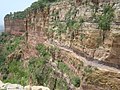 Accessing Daba Selama monastery requires a perillous climb.
 -
 The May Baha and Dabba Selama area, as seen from an Italian spy flight in 1936.


References
- ^ Sembroni, A.; Molin, P.; Dramis, F. (2019). Regional geology of the Dogu'a Tembien massif. In: Geo-trekking in Ethiopia's Tropical Mountains - The Dogu'a Tembien District. SpringerNature. ISBN 978-3-030-04954-6.
- ^ a b What do we hear from the farmers in Dogu'a Tembien? [in Tigrinya]. Hagere Selam, Ethiopia. 2016. p. 100.
{{cite book}}: CS1 maint: location missing publisher (link) - ^ Naudts, J (2002). Les Hautes Terres de Tembien, Tigré, Ethiopie; Résistance et limites d'une ancienne civilisation agraire; Conséquences sur la dégradation des terres [MSc dissertation]. CNEARC, Montpellier, France.
- ^ a b Jacob, M. and colleagues (2019). Geo-trekking map of Dogu'a Tembien (1:50,000). In: Geo-trekking in Ethiopia's Tropical Mountains - The Dogu'a Tembien District. SpringerNature. ISBN 978-3-030-04954-6.
- ^ Plant, R.; Buxton, D. (1970). "Rock-hewn churches of the Tigre province". Ethiopia Observer. 12 (3): 267.
- ^ a b Gerster, G. (1972). Kirchen im Fels – Entdeckungen in Äthiopien. Zürich: Atlantis Verlag.
- ^ Description of trekking routes in Dogu'a Tembien. In: Geo-trekking in Ethiopia's Tropical Mountains - The Dogu'a Tembien District. GeoGuide. SpringerNature. 2019. doi:10.1007/978-3-030-04955-3. ISBN 978-3-030-04954-6. S2CID 199294303.
- ^ Socio-demographic profile, food insecurity and food-aid based response. In: Geo-trekking in Ethiopia's Tropical Mountains - The Dogu'a Tembien District. GeoGuide. SpringerNature. 2019. doi:10.1007/978-3-030-04955-3. ISBN 978-3-030-04954-6. S2CID 199294303.
- ^ Hartjen, Clayton A.; Priyadarsini, S. (2012), Hartjen, Clayton A.; Priyadarsini, S. (eds.), "Denial of Education", The Global Victimization of Children: Problems and Solutions, Boston, MA: Springer US, pp. 271–321, doi:10.1007/978-1-4614-2179-5_8, ISBN 978-1-4614-2179-5, retrieved 2023-10-12
- ^ Geo-trekking in Ethiopia's Tropical Mountains - The Dogu'a Tembien District. GeoGuide. SpringerNature. 2019. doi:10.1007/978-3-030-04955-3. ISBN 978-3-030-04954-6. S2CID 199294303.
- ^ Miruts Hagos and colleagues (2019). "Geosites, Geoheritage, Human-Environment Interactions, and Sustainable Geotourism in Dogu'a Tembien". Geo-trekking in Ethiopia's Tropical Mountains. GeoGuide. SpringerNature. pp. 3–27. doi:10.1007/978-3-030-04955-3_1. ISBN 978-3-030-04954-6. S2CID 199095921.
- ^ Aerts, R.; Lerouge, F.; November, E. (2019). Birds of forests and open woodlands in the highlands of Dogu'a Tembien. In: Geo-trekking in Ethiopia's Tropical Mountains - The Dogu'a Tembien District. SpringerNature. ISBN 978-3-030-04954-6.
- ^ Nyssen, Jan (2019). "Description of Trekking Routes in Dogu'a Tembien". Geo-trekking in Ethiopia's Tropical Mountains. GeoGuide. Springer-Nature. pp. 557–675. doi:10.1007/978-3-030-04955-3_38. ISBN 978-3-030-04954-6. S2CID 199271514.
- ^ "Public GPS Traces tagged with nyssen-jacob-frankl".
- ^ Nyssen, Jan (2019). "Logistics for the Trekker in a Rural Mountain District of Northern Ethiopia". Geo-trekking in Ethiopia's Tropical Mountains. GeoGuide. Springer-Nature. pp. 537–556. doi:10.1007/978-3-030-04955-3_37. ISBN 978-3-030-04954-6. S2CID 199198251.
Places adjacent to Degol Woyane | ||||||||||||||||
|---|---|---|---|---|---|---|---|---|---|---|---|---|---|---|---|---|
| ||||||||||||||||