
Church of St. Donatus
| Church of Saint Donatus | |
|---|---|
| Crkva svetog Donata | |
.JPG) Church of St Donatus, Zadar | |
 | |
| Location | Zadar, Croatia |
| Country | |
| Denomination | Roman Catholic |
| History | |
| Former name(s) | Church of the Holy Trinity |
| Founded | 9th century |
| Founder(s) | Donatus of Zadar |
| Architecture | |
| Style | Pre-Romanesque[1] |
| Part of a series on the |
| Catholic Church in Croatia |
|---|
 |
The Church of St. Donatus (Croatian: Crkva sv. Donata) is a church located in Zadar, Croatia. Its name refers to Donatus of Zadar, who began construction on this church in the 9th century and ended it on the northeastern part of the Roman forum.[2]
Originally named Church of the Holy Trinity,[3] in the 15th century it was re-dedicated to St Donatus.[4] The church is the largest Pre-Romanesque building in Croatia. It is also an example of the centralised type of the Carolingian period in Europe.[citation needed]
History
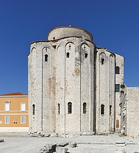
The beginning of the building of the church was placed to the second half of the 8th century, and it is supposed to have been completed in the 9th century. The Zadar bishop and diplomat Donatus of Zadar (8th and 9th centuries) is credited with the building of the church. He led the representations of the Dalmatian cities to Constantinople and Charles the Great, which is why this church bears slight resemblance to Charlemagne's court chapels, especially the one in Aachen (now Aachen Cathedral),[5] and also to the Basilica of San Vitale in Ravenna.[6] It belongs to the Pre-Romanesque architectural period.
The circular church, formerly domed, is 27 m high and is characterised by simplicity and technical primitivism. It has three radially situated apses and an ambulatory around the central area, surmounted by circular gallery. The circular shape is typical of the early medieval age in Dalmatia.[1] It was built on the Roman forum, and materials from buildings in the latter were used in its construction.[7] Among the fragments which are built into the foundations it is still possible to distinguish the remains of a sacrificial altar on which is written IVNONI AVGUSTE IIOVI AVGUSTO.[5]
The use of the church has varied during its lifetime; during the rule of the Republic of Venice it was a warehouse, as well as during the French occupation and under the Austrians. After the city was annexed to Yugoslavia, it served as an archaeological museum for a short period of time. The building is currently used as the concert venue for the annual International Festival of Medieval Renaissance Music (Musical Evenings in St Donatus) because of its acoustics.[8]
Gallery
-
 Interior
 -
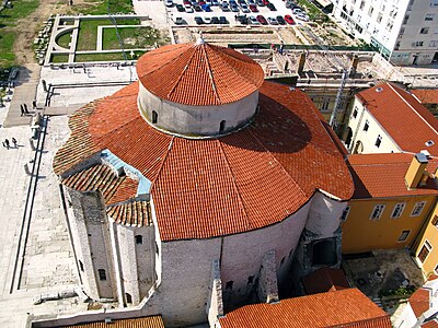 Aerial view
 -
 Detail
 -
 With the belltower of Zadar Cathedral
 -
 As seen in the morning
 -
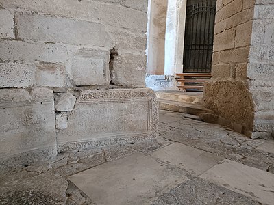 Roman temple ruins used in the foundation


See also
- Architecture of Croatia
- Church of Holy Salvation
- Church of Holy Cross in Nin
- Pre-Romanesque art and architecture
References
- ^ a b PlanetWare.com - Church of Saint Donat
- ^ (in Croatian) Arheološki Muzej Zadar - Sveti Donat
- ^ Essential Zadar Archived 2007-12-22 at the Wayback Machine, inyourpocket.com; accessed 31 July 2018.
- ^ (in Croatian) Crkva sv. Donat Archived 2012-03-27 at the Wayback Machine, izaberi.hr; accessed 31 July 2018.(in Croatian)
- ^ a b Radovinovič, Radovan (1998). The Croatian Adriatic. Zagreb: Naklada Naprijed. p. 164. ISBN 953-178-097-8.
- ^ Raos, Ivan (1969). Adriatic tourist guide. Zagreb: Spektar. p. 80. OCLC 112865.
- ^ Cvitanic, Marilyn (2010). Culture and Customs of Croatia (Culture and Customs of Europe). Greenwood; 1st ed. p. 200. ISBN 978-0-313-35117-4.
- ^ Official site of the Donat musical evenings, donat-festival.com; accessed 31 July 2018.
Sources
- Jadranka Damjanov, Likovna umjetnost 1, Školska knjiga, Zagreb, 1971; ISBN 953-0-20109-5
- Radovan Ivančević, Treso r Artistique de la Croatie, Jugoslovenska revija, Motovun, 1986.
- Antun Karaman, Opća povijest umjetnosti, Školska knjiga, Zagreb, 2004; ISBN 953-0-21319-0
Further reading
- "The First Croatian State". culturenet.hr. Archived from the original on 28 June 2013. Retrieved 2 December 2012.
44°6′56.96″N 15°13′28.11″E / 44.1158222°N 15.2244750°E
| Zadar |  | |
|---|---|---|
| Šibenik-Knin | ||
| Split-Dalmatia | ||
| Dubrovnik-Neretva | ||
| Islands | ||
| International | |
|---|---|
| National | |