
Chowrasta (Darjeeling)
This article needs additional citations for verification. (March 2024) |
 Chowrasta (Band Stand), Darjeeling in 1880 | |
| Former name(s) | Band Stand |
|---|---|
| Maintained by | Darjeeling Municipality |
| Location | Darjeeling, West Bengal, India |
| Postal code | 734101 |
| North | Sikkim |
| East | Kalimpong, Bhutan |
| South | Kurseong |
| West | Nepal |
| Construction | |
| Completion | c. mid-18th century |

Chowrasta "Intersection" lit. where four roads meet) is a historical public square in the Victorian era hill resort town of Darjeeling in the state of West Bengal, India. Located in the heart of the town it was the fashionable place of assembly for residents and visitors in the 18th century. Chowrasta is situated on the ridge of the Darjeeling hill range and is now a center of tourist attraction and a popular spot for the residents to assemble.[1][2][better source needed]
Geography
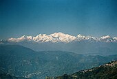
Chowrasta is perched at an altitude of 2,134 metres (7,001 ft) and on a clear day, one can see Mount Kanchenjunga the third highest mountain in the world and twelve other peaks of the Himalayan Range, all which are above 20,000 feet (6,100 m). It came into being during the Victorian era in the mid 18th century owing to Darjeeling's cool climate, which was similar to that of London, the British established a hill station for its officials there.[citation needed]
The square is lined with old stores (the oldest being Oxford Book & Stationery); towards the west is are hills and to the east are valleys.[citation needed]
Although it is closed to all vehicles, Chowrasta is well connected to Darjeeling town and is at an accessible proximity from all parts of the Darjeeling hill range.[3] Two main road arteries of the town, Nehru Road and Dr Zakir Hussain Road, culminate at Chowrasta and so do the two ends of Mall Road which winds around Observatory Hill and Mahakal Temple. Both ends of the Mall Road meet at Chowrasta from the north. There are few other narrow roads and footpaths which terminate and originate at Chowrasta.[2][4][better source needed]
Social and tourist significance
Chowrasta is the social center of Darjeeling and witnesses many cultural and political activities throughout the year. A few coffee shops and restaurants have grown around it over the years. Activities available include pony rides along the Mall Road.[5][better source needed]
Statues, monuments and developments
On the far North of the square stands a golden concrete statue of Nepali poet Shri Bhanubhakta Acharya. Initially, a 'bust above' statue of the Acharya was erected on 17 June 1949 and a full life sized figure was reinstalled on 13 July 1996, commissioned by the Nepali Sahitya Sammelan.[citation needed] In 2014 a park located behind the statue was developed into a stepped concrete platform for public events.[2][better source needed]
Immediately after the entrance from Nehru Road is a water fountain ornamented with concrete golden colored fishes and pelicans, however the fountain is nonoperational.[citation needed]
The Hawa Ghar (translation: wind house) is a permanent roofed concrete stage-like structure on the east edge of Chowrasta where cultural programs, performances and political speeches take place.[2][better source needed]

Chaurasta has a pigeon population and feeding them is a popular activity. Their droppings disfigure the Bhanubhakta statue and other stonework; the birds are not considered a health or public hazard.[2][better source needed]
See also
Gallery of pictures
-
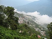 View from Mall Road
 -
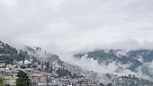 View from Chowrasta
 -
 Kanchenjunga
 -
 First light on Kanchenjunga
 -
 Darjeeling town
 -
 Mt. Kanchanjunga


References
- ^ "Return of the queen". hinduonnet.com. 26 September 2007. Archived from the original on 26 September 2007. Retrieved 17 August 2018.
{{cite web}}: CS1 maint: unfit URL (link) - ^ a b c d e win7. "Darjeeling Mall, Chowrasta". www.darjeeling-tourism.com. Retrieved 16 August 2018.
{{cite web}}: CS1 maint: numeric names: authors list (link) - ^ "chowrasta and the mall - ixigo trip planner!". www.ixigo.com. Retrieved 15 August 2018.
- ^ "Darjeeling, Hill Station Darjeeling, hill stations in India, Hill Stations in West Bengal, scenic places, tourism". tourism.webindia123.com. Retrieved 17 August 2018.
- ^ Guides, Bluworlds; Das, Joydip. Darjeeling Pocket Travel Guide. Bluworlds Guides.