
Castleknock
Castleknock
Caisleán Cnucha | |
|---|---|
Suburb (village core) | |
 Castleknock Location in Ireland | |
| Coordinates: 53°22′26″N 6°21′32″W / 53.374°N 6.359°W | |
| Country | Ireland |
| Province | Leinster |
| County | Fingal |
| Council | Fingal County Council |
| Dáil Éireann | Dublin West |
| EU Parliament | Dublin |
| Elevation | 63 m (207 ft) |
| Population | |
| • Urban | 27,049 |
| Postal district(s) | |
| Dialing code | 01, +353 1 |
| Irish Grid Reference | O078378 |
Castleknock (Irish: Caisleán Cnucha) is an affluent suburb located 8 km (5 mi) west[3] of the centre of Dublin city, Ireland. It is centred on the village of the same name in Fingal.[4][5]
In addition to the suburb, the name "Castleknock" also refers to older units of land division: a townland,[4 1] a civil parish[4 2] and a barony.[4 3]
Etymology
In a poem relating to the earliest centuries after Christ, the origin of the name Cnucha is connected with Conn of the Hundred Battles, and the name is said to have been borne by his foster mother: —
The nurse of Conn who loved this strip of land
Was Cnucha of the comely head;
She dwelt on the dun with him
In the reign of Conn of the Hundred Fights.
Cnucha, the daughter of Concadh Cas,
From the land of Luimncach broad and green,
Died yonder in that house
To the horror of the Gaels.
The woman was buried, a grief it was.
In the very middle of the hill ;
So that from that on Cnucha
Is its name until the judgment.[6]
As the word Castle did not come into use in Ireland until Norman times we know that Castleknock is a name of comparatively recent origin. Documents from the 12th and 13th centuries refer to the place as Castrum Cnoc, simply Cnoc and also Chastel-cnoc or Castel-Cnoc.[7] So it seems[according to whom?] that the name Castleknock is rooted in the topography of the hill or cnoc located at the centre of the modern neighbourhood and/or the personal name of the mother of a semi-legendary High King i.e. Cnucha and the building of a castle by Normans on this site in the 12th century.
History
Gaelic period
There is some documentary evidence in chapter 72 of the Life of St. Patrick by Jocelin of Furness to support the belief that when St. Patrick had finished his visit to the City of Dubh Linn he came to Castleknock to try to convert Murinus, the local ruler of the place. Despite his efforts Patrick was unsuccessful and departed while imparting a curse on the King.[8]
According to the Four Masters in the year 726 the death occurred of Congalach of Cnucha.[9]
In 916 the Annals tells us that Niall Glindubh of the Northern Uí Neill became High King of Ireland and is referred to as "Niall of Cnucha" which signifies both the ascent of Cnucha (Castleknock) in prominence as well as the descent of Tara as a royal seat. In September 919, Niall gathered the Irish Chiefs and their armies at Castleknock from where they led a fight against the Danes who had regained their power over Dublin. The Battle of Islandbridge, also known as the Battle of Áth Cliath, proved to be Niall's last battle. He was slain along with five other Irish Chiefs and their armies were subdued.[10]
Feudal period
In 1171, the High King of Ireland, Ruaidrí Ua Conchobair, gathered his forces at Cnucha to counter the Norman invasion of Ireland. Ua Conchobair was comfortable at Cnuch having overcome his Danish vassals in the Kingdom of Dublin some years previously. The siege exerted pressure on the forces of the Cambro-Norman leader, Strongbow, who asked the Archbishop of Dublin, Lawrence O'Toole to negotiate with the High King at Cnucha. Strongbow's offer to recognise Ua Concubhair as High King was rejected. He was commanded to depart from Ireland immediately. Strongbow was furious but Maurice de Prendergast, who had accompanied Archbishop O'Toole, had observed that the Irish troops were largely inactive and unready for battle. His report to Strongbow spurred him to lead a successful attack against the High King's armies. Ua Concubhair fell back from Cnucha and the other Irish Chiefs returned to their territories. The battle was lost and the Norman conquest of Ireland was successful.[11] Following the siege, the Normans realised the strategic importance of the location which looked over the city of Dublin. Consequently in 1177, a feudal barony of Castleknock was created out of the Lordship of Meath by Hugh de Lacy, Lord of Meath who granted it to Hugh Tyrrel. It was held for three and a half knight's fees, owed to the superior Lord of Fingal.
The title and lands of Castleknock were held by the Tyrell family until 1370 when Hugh Tyrell and his wife died of the plague. It passed by inheritance to the Burnell family. The first Baron, Hugh Tyrrel, gave lands in the barony at Kilmainham to the Knights of St. John whose legacy continues in the area today in the form of St. John Ambulance. Later, civil parishes, based on the boundaries of the ecclesiastical parishes of the Established church were used to sub-divide the barony.
In 1185, the second baron, Richard de Tyrell, gave a grant of land to the Benedictine Monks of the Abbey of Little Malvern, Worcestershire, to endow a religious house at Castleknock in honour of Saint Brigid.[12] Later they built a chapel, the White Chapel at Coolmine, which served the parish of Clonsilla. In 1219 the great tithes of the parish were appropriated by Archbishop Henry de Londres to the Priory of Malvern on condition that they should add five monks to their number. In 1225 the monks granted half of the tithes of the manor of Castleknock to the use of St Patrick’s Cathedral, renouncing to the Archbishop all rights to the vicarage and its small tithes and oblations. In 1226 the first Prebendary of Castleknock, Richard De Gnouessale, was appointed. However, by 1468 the church and lands at Castleknock were transferred to the ownership of the Abbey of St Mary in Dublin city.
Modern period
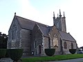
Following the English Reformation and the dissolution of the monasteries under Henry VIII of England, the Priory at Castleknock was destroyed and in 1609 a church was built on the site for the use of the Church of Ireland. The foundation stone of the church, which is in use today, still on the site of the Abbey, was laid in 1803.[13] The spire was added in 1864 by friends of the late James Hans Hamilton as a memorial to the 1st Baron Holmpatrick of Abbottown and MPfor the County of Dublin.
Castleknock eventually came to be divided among a number of important families and their country estates. These included the Guinnesses at Farmleigh, and Knockmaroon, the Laidlaws at Abbey Lodge, the Godleys at Oatlands, and the Brookes at Sommerton House.[14] The Earl of Iveagh's principal seat was at Farmleigh until 1999 when it was purchased by the Government of Ireland. It was restored and converted into a State Guest House and opened to the public in 2001. Although they left Farmleigh in 1999, the Guinness family are still present in Castleknock at Knockmaroon House and its Demesne, located on Carpenterstown Road and the seat of Lord Moyne. The Brooke Baronets lived at Sommerton House until they sold it in 1911 to the Laidlaw family who were resident at Sommerton and Abbey Lodge until the 1980s.[15]
Castleknock today

The neighbourhood has developed and extended around the old village, which is a busy commercial centre with several supermarkets and other retail outlets. There are several cafes and restaurants, and a post office.
Location and access


Castleknock contains three townlands, Castleknock, Carpenterstown, and Diswellstown and is divided across two electoral divisions.
The neighbourhood is located mostly between Phoenix Park and the Royal Canal.[16] The neighbourhood is bordered to the west by the large suburb of Blanchardstown, to the east by the Phoenix Park, to the north by Dunsink and to the south by the village of Chapelizod above the Liffey valley. The suburb is in the Dublin 15 postal area.
The area can be accessed from Junction 6 on the M50 motorway, on either side of which it lies, from the R147 Navan Road, from Chesterfield Avenue and the Castleknock Gate of the Phoenix Park, and via Knockmaroon Hill in Chapelizod. Dublin Bus operate a number of services through Castleknock. These include Route 37 which runs from Blanchardstown Town Centre to Wilton Terrace, Baggot Street, and Route 38 from Burlington Road, in the southern part of Dublin city centre, towards Damastown and vice versa.
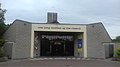
Irish Rail operate Dublin Suburban Rail on the Western Suburban Railway Line or Maynooth Line from Dublin Connolly to Maynooth. An earlier railway station was designed by John Skipton Mulvaney and completed in 1849 at Castleknock. The landmark was demolished in the late 1980s to make way for the M50 motorway. A new modern Castleknock railway station was built close by and opened on 2 July 1990.[17][18]
The Royal Canal was completed in 1817 to transport freight and passengers from the River Liffey in the City of Dublin to Longford. Having fallen into disuse at the start of the 20th century the canal is now restored and mostly used for pleasure. The canal's 12th lock is located at Castleknock Marina.
The Diswellstown Stream rises in two branches in the area. One branch comes from Carpenterstown, where Bracken Park Drive now lies and is culverted for its first stretch. The other comes from south of Park Avenue in Castleknock village and flows in the open along the western edge of the Castleknock College grounds. The branches come together near the area known as the Sand Holes or Sandpits in Diswellstown, and the stream flows directly south to join the Liffey.[19]
Education
There are three primary schools in the village: Castleknock National School (Church of Ireland), St Brigid's Primary School (Catholic), and Educate Together (non-denominational). Outside the village proper, Scoil Thomáis (co-educational) is located in the Laurel Lodge district, while St Patrick's (co-educational) is in the townland of Diswellstown. A state secondary school, Castleknock Community College (multi-denominational), is located on Carpenterstown Road. A fee-paying secondary school for girls, Mount Sackville, under the care of the Sisters of St. Joseph of Cluny, is located on Tower Road, Knockmaroon Hill, Chapelizod. The suburb is also home to Castleknock College, a voluntary Vincentian secondary school for boys which has produced numerous alumni in the fields of arts, politics, sports, science and business.[20][21][22][23]
Religion
In the Church of Ireland, the church of St Brigid, sited on the ruins of an ancient monastery, is located in the middle of the village.[24] In the Catholic Church, there are two parishes in the area: "Our Lady Mother of the Church", located close to the village and St Thomas the Apostle parish, Laurel Lodge. Both St Brigid's and St Thomas the Apostle contain windows from the Harry Clarke Studios. The window in St Brigid's was commissioned in 1927 by R.F. Brookes of Somerton House, Castleknock, to commemorate members of his family, whereas the Harry Clarke window in St Thomas the Apostle was donated by the Dominican Order after their convent at Dún Laoghaire closed in 1991. It depicts the Immaculate Conception of Mary.
Holy wells
In the townland of Diswellstown, there is a historic "rag well" - a holy well near which rags were left. Although it still flows, it was "buried" by Dublin County Council, and its site is now marked by a carved flagstone. It used to be attended especially on the eve of May 1.[25]
A second holy well, dedicated to St Brigid is located near the Church of Ireland church in Castleknock village; its spring, still flowing, has been covered by a pump for many years. Adjacent are stones with two quotations from the Bible. Local tradition held that the water of the well was safe for humans and hazardous for "lower animals".[26][27]
Government and representation
Castleknock is located in the "Castleknock ward" for the purposes of elections to Fingal County Council. For national polls, it is in the Dublin West Dáil constituency and for European Parliament elections, the Dublin constituency.
Gallery
Features and access
-
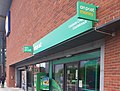 Castleknock Post Office
 -
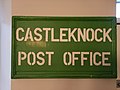 Castleknock old Post Office sign in a dental office
 -
 Old Post Office
 -
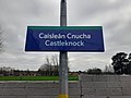 Bilingual sign at Castleknock train station
 -
 Bilingual sign on Castleknock Road
 -
 Pump and tablets by St Brigid's
 -
 Stone tablet by water pump
 -
 Royal Canal at Castleknock
 -
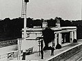 Old Railway Station, Castleknock (now demolished)
 -
 Castleknock train station
.jpg)


.jpg)
.jpg)


Religion
-
 "St. Brigid's"
Church of Ireland -
 "Our Lady Mother of the Church",
Catholic Church -
 St. Thomas the Apostle Church, Laurel Lodge
 -
 Stained glass window, St. Thomas the Apostle, Laurel Lodge


.jpg)

Education and facilities
-
 Castleknock College viewed from the Carpenterstown Road
 -
 Church of Ireland primary school, on its 300th anniversary
 -
 "Educate Together" national school, Beechwood Avenue
 -
 Scoil Thomáis national school, Laurel Lodge
 -
 Castleknock Community College, Carpenterstown
 -
 Castleknock Community Centre, Laurel Lodge


See also
References
From "Irish placenames database". logainm.ie (in English and Irish). Department of Community, Rural and Gaeltacht Affairs. Retrieved 13 April 2020.
- ^ "Castleknock townland | logainm.ie". logainm.ie. Archived from the original on 26 September 2021. Retrieved 13 April 2020.
- ^ "Castleknock civil parish | logainm.ie". logainm.ie. Archived from the original on 26 April 2014. Retrieved 13 April 2020.
- ^ "Castleknock barony| logainm.ie". logainm.ie. Archived from the original on 27 April 2014. Retrieved 13 April 2020.
Other: [28]
- ^ "Census 2006 – Volume 1 – Population Classified by Area" (PDF). Central Statistics Office Census 2006 Reports. Central Statistics Office Ireland. April 2007. Archived from the original (PDF) on 7 June 2011. Retrieved 12 June 2011.
- ^ [1] Archived 17 April 2019 at the Wayback Machine Census 2011- population classified by area: see two references to Castleknock under Fingal areas.
- ^ Geographic co-ordinates from GPO to Post Office in Castleknock: from 53.349501,-6.260287 to 53.373024,-6.362393
- ^ Note: The name is commonly mistranslated as "Castle on the hill". Originally the village was named simply "Cnucha" after a woman of that name, likely a member of the Firbolg, was buried in a mound near the ruin of Castleknock Castle on the grounds of Castleknock College.
- ^ "The Pre-Christian Era". www.iol.ie. Archived from the original on 4 March 2016. Retrieved 13 April 2018.
- ^ A HISTORY OF COUNTY DUBLIN: FRANCIS ELRINGTON BALL https://archive.org/stream/historyofcountyd06ball/historyofcountyd06ball_djvu.txt
- ^ Castleknock College Centenary Record, 1935. available on https://www.knockunion.ie/news/castleknock-castle-its-owners-354 Archived 22 September 2020 at the Wayback Machine
- ^ Life of St Patrick, by Jocelin of Furness, ed. by Ingrid Sperber and Ludwig Bieler, in Royal Irish Academy Archive of Celtic-Latin literature, ed. by Anthony Harvey and Angela Malthouse (2nd development and expanded edition, ACLL-2)
- ^ "Annals of the Four Masters". Archived from the original on 27 July 2020. Retrieved 15 April 2020.
- ^ Forte, Oram and Pedersen, p. 103; Annals of Ulster, s.a. 919
- ^ Lewis, Samuel. A topographical dictionary of Ireland. Volume 1. London: S. Lewis & Co., 1837. Size: 160.9M bytesModified: 28 May 2009, 09:57
- ^ Harris's Table in Ware-Harris, Antiquitie, 1745 and Mervyn Archdall, Monasticon Hibernicum, 1786
- ^ Church of Ireland Archived 1 March 2021 at the Wayback Machine - History of Castleknockparish
- ^ "Knockmaroon Estate – Local History Castleknock". 27 April 2018. Archived from the original on 13 April 2020. Retrieved 13 April 2020.
- ^ "Laidlaw family". History of Castleknock. 16 November 2017. Archived from the original on 13 April 2020. Retrieved 30 July 2021.
- ^ "GeoHive". Archived from the original on 6 July 2020. Retrieved 11 May 2019.
- ^ Reynolds, T. 2017. Castleknock, Memories of A Neighbourhood. Carrowmore.
- ^ Lacey, J. 2015. The Barony of Castleknock, A History. Dublin. The History Press.
- ^ Doyle, Joseph W. (September 2013). Ten Dozen Waters: The Rivers and Streams of County Dublin (8th ed.). Dublin, Ireland: Rath Eanna Research. p. 35. ISBN 9780956636379.
- ^ "Liam Cosgrave SC, RIP". St. Vincent's Castleknock College. 5 October 2017. Archived from the original on 15 December 2019. Retrieved 3 May 2020.
- ^ McCarry, Patrick (2 July 2014). "'Do I want to be a pro? Hell yeah!' Devin Toner reaping benefits of seeds sewn long ago". The42. Archived from the original on 30 December 2015. Retrieved 3 May 2020.
- ^ "Alexander Amini, class '12, wins EU Young Scientist Award". KnockUnion.ie. Archived from the original on 25 November 2017. Retrieved 3 May 2020.
- ^ "The old boys' club: Ireland's most influential privately educated men and the elite schools that spawned them". independent. 24 October 2016. Archived from the original on 27 March 2021. Retrieved 3 May 2020.
- ^ Church of Ireland Archived 1 March 2021 at the Wayback Machine - History of Castleknockparish
- ^ Sweeney, Clair L. (1991). The Rivers of Dublin (1st ed.). Dublin: Dublin Corporation. pp. 110–111. ISBN 095053014X.
- ^ "St Brigid's Well (Kildare and others)". Ask About Ireland. Government of Ireland. Archived from the original on 20 February 2020. Retrieved 23 May 2020.
- ^ Sweeney, Clair L. (1991). The Rivers of Dublin (1st ed.). Dublin: Dublin Corporation. p. 111. ISBN 095053014X.
- ^ "Castleknock Gaa Club". Castleknock.net. Web Design Dublin by Webtrade. Archived from the original on 13 November 2016. Retrieved 28 November 2016.
External links
Places in Fingal | |||||||||||||
|---|---|---|---|---|---|---|---|---|---|---|---|---|---|
| Towns and large suburbs |  | ||||||||||||
| Villages and smaller suburbs | |||||||||||||
| Baronies broken out by civil parish (* denotes article not on the civil parish or barony specifically but on the modern district, village or town of the same name) |
| ||||||||||||
| International | |
|---|---|
| National | |