
Carrick-a-Rede Rope Bridge
Carrick-a-Rede Rope Bridge Carraig a'Ráid | |
|---|---|
 | |
| Coordinates | 55°14′24.13″N 6°19′51.76″W / 55.2400361°N 6.3310444°W |
| Locale | Ballintoy, County Antrim |
| Characteristics | |
| Design | simple suspension bridge |
| Material | Rope |
| Total length | 20 metres (66 ft) |
| Width | 1 metre (3.3 ft) |
| Height | 30 metres (98 ft) |
| No. of spans | 1 |
| Load limit | 8 pedestrians |
| History | |
| Constructed by | Heyn Construction |
| Opened | 2008 (current bridge) |
| Statistics | |
| Toll | £14 – £15.50 (adult) £7 – £7.75 (child) |
| Location | |
 | |
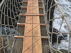
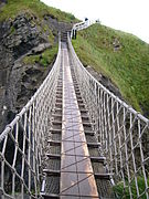
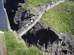
The Carrick-a-Rede Rope Bridge (locally pronounced carrick-a-reed) is a rope bridge near Ballintoy in County Antrim, Northern Ireland. The bridge links the mainland to the tiny island of Carrickarede (from Irish Carraig a' Ráid, meaning 'rock of the casting').[1] It spans 20 metres (66 ft) and is 30 metres (98 ft) above the rocks below.[2] The bridge is mainly a tourist attraction and is owned and maintained by the National Trust.[3] In 2018, the bridge had 485,736 visitors.[4] The bridge is closed for winter (subject to weather) and people may cross it for a £13.50 to £15.50 (adult) fee.[5]
History

It is thought salmon fishermen have been building bridges to the island for over 350 years. It has taken many forms over the years. In the 1970s it had only one handrail and large gaps between the slats.[6] A new bridge, tested up to ten tonnes, was built with the help of local climbers and abseilers in 2000.[7] Another was built in 2004 and offered visitors and fishermen alike a much safer passage to the island. The current wire rope and Douglas fir bridge was made by Heyn Construction in Belfast and raised early in 2008 at a cost of over £16,000.[8] There have been many instances where visitors, unable to face the walk back across the bridge, have had to be taken off the island by boat.[9]
On 24 May 2017, a routine inspection revealed that the bridge's structural ropes had been damaged overnight in an act of vandalism.[10] The National Trust announced that the bridge would be closed "for the foreseeable future".[11] However, on the following day it was announced that structural engineers had completed repairs, and that the bridge had been reopened.[12]
Fishing
It is no longer used by fishermen during the salmon season, which used to last from June until September, as there are now very few salmon left. In the 1960s, almost 300 fish were caught each day, but by 2002, only 250 were caught over the whole season. The salmon come through the area to spawn in the River Bann and the River Bush.[7]
Features
There are views of Rathlin Island and Scotland from the area. The site and surrounding area is designated an Area of Special Scientific Interest for its unique geology, flora, and fauna. Underneath there are large caves, which once served as home for boat builders and as shelter during stormy weather.[citation needed]
Geology
Carrickarede island is the best example of a volcanic plug in Northern Ireland. Marine erosion has exposed a section through the neck of this old volcano.[13]
The presence of tuff, explosion breccias, grey volcanic ash and explosion bombs show the extreme violence of the eruptions about 60 million years ago when molten rock punched its way through chalk.[14]
Along the coast of this area, as with much of the Antrim plateau, the cliffs are of basalt with the characteristic Ulster chalk underneath. At Carrickarede, the ancient volcanic pipe has left dolerite, a tougher rock than basalt, which erodes more slowly. Behind the dolerite, to the south, the vent is filled with pyroclastic rocks that break down more easily, mostly a coarse tuff agglomerate. The combination of the hard rock out front and the softer rock behind, with long-term erosion by the waves, has eventually left this small island.[13]
In popular culture
A plate of this bridge (Artist: Thomas Mann Baynes – Engraved by: J. Davies) appeared in Fisher's Drawing Room Scrap Book, 1832, accompanied by a poetical illustration by Letitia Elizabeth Landon (L. E. L.) referring to a gentleman who is supposed to have lived on the island as a hermit at one time (possibly a rebel who had fled out of Scotland).[15]
Seamus Heaney describes the bridge in his 1978 poem A Postcard from North Antrim:[16]
A lone figure is waving
From the thin line of a bridge
Of ropes and slates, slung
Dangerously out between
The cliff-top and the pillar rock.
Gallery
-
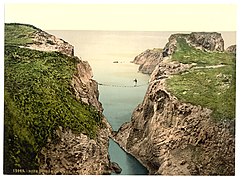 Photochrom of the Bridge, c. 1890
 -
 Bridge structure, 2004
 -
 Bridge structure, 2005
 -
 Carrick-a-Rede Rope Bridge, 2006
 -
 Carrick-a-Rede Rope Bridge, 2007
 -
 Bridge in use 2010
 -
 View of the bridge and island
 -
 The bridge in 2017


See also
References
- ^ "Carraig an Ráid/Carrickarede Island". Logainm.ie.
- ^ "Carrick-a-Rede". Archived from the original on 28 March 2008. Retrieved 23 August 2007.
- ^ "Carrick-a-Rede". National Trust. Retrieved 25 January 2018.
- ^ "ALVA – Association of Leading Visitor Attractions". alva.org.uk. Retrieved 23 October 2020.
- ^ https://www.nationaltrust.org.uk/visit/northern-ireland/carrick-a-rede
- ^ McCreary, Mark (29 June 2016). "Brave or bonkers? Rope bridge pics to make you shudder..." belfastlive. Retrieved 25 January 2018.
- ^ a b "Carrick-a-Rede Rope Bridge | Scenic Attractions Ireland". irishtourism.com. Retrieved 25 January 2018.
- ^ "New Rope Bridge For Carrick-a-Rede". Archived from the original on 9 June 2008. Retrieved 30 May 2008.
- ^ "World's Scariest Bridges". Travel + Leisure.
- ^ "Vandalism closes Carrick-a-Rede Rope Bridge" (Press release). National Trust. 25 May 2017. Archived from the original on 25 May 2017. Retrieved 25 May 2017.
- ^ Young, David (25 May 2017). "Rope bridge closed after vandals try to cut it down". Evening Herald. Dublin. Archived from the original on 25 May 2017. Retrieved 25 May 2017.
- ^ National Trust Carrick-a-Rede (25 May 2017). "Good news! Carrick-a-Rede Rope Bridge has reopened". Archived from the original on 25 May 2017. Retrieved 25 May 2017 – via Twitter.
- ^ a b Habitas, Earth Science Conservation Review, National Museums Northern Ireland, Ballintoy – Ballycastle
- ^ Habitas, Earth Science Conservation Review, National Museums Northern Ireland, Ballintoy – Ballycastle (summary)
- ^ Landon, Letitia Elizabeth (1831). "picture". Fisher's Drawing Room Scrap Book, 1832. Fisher, Son & Co.Landon, Letitia Elizabeth (1831). "poetical illustration". Fisher's Drawing Room Scrap Book, 1832. Fisher, Son & Co.
- ^ Muldoon, Paul, ed. (1999). The Faber book of contemporary Irish poetry ([11. print] ed.). London [u.a.]: Faber and Faber. ISBN 0-571-13761-X.
External links
- National Trust – Carrick-a-Rede
- New Rope Bridge for Carrick-a-Rede. CultureNorthernIreland.org Feature
| Volcanism |  | |
|---|---|---|
| Volcanic plugs | ||
| Dykes and sills | ||
| Metamorphic | ||
| Sedimentary | ||
| Lists | ||