Arapaho National Recreation Area
Appearance
| Arapaho National Recreation Area | |
|---|---|
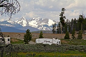
 Green Ridge Campground in Arapaho NRA | |
| Location | Grand County, Colorado, United States |
| Nearest city | Granby, Colorado |
| Coordinates | 40°08′38″N 105°48′50″W / 40.144°N 105.814°W[1][2] |
| Area | 30,690 acres (124.2 km²) |
| Established | 1978 |
| Governing body | United States Forest Service |
| Website | Arapaho National Recreation Area |
The Arapaho National Recreation Area (ANRA) is a United States national recreation area located near the headwaters of the Colorado River in north central Colorado adjacent to Rocky Mountain National Park. ANRA is under the jurisdiction of the Arapaho-Roosevelt National Forest. ANRA contains five lakes in the upper Colorado River Valley:
A sixth lake, Grand Lake, borders the recreation area on the north. Grand Lake is the largest natural lake in Colorado. Collectively, these six lakes are known as "The Great Lakes of Colorado."[3]
The Continental Divide National Scenic Trail passes through the recreation area.
References
- ^ "Arapaho National Recreation Area (Usfs)". protectedplanet.net. Archived from the original on 2011-11-24.
- ^ "Arapaho National Recreation Area". Geographic Names Information System. United States Geological Survey, United States Department of the Interior. Retrieved August 8, 2012.
- ^ "Arapahoe & Roosevelt National Forests". USDA Forest Service. Archived from the original on 2 Oct 2021.

