
Portal:Geography
The Geography Portal

Geography (from Ancient Greek γεωγραφία geōgraphía; combining gê 'Earth' and gráphō 'write') is the study of the lands, features, inhabitants, and phenomena of Earth. Geography is an all-encompassing discipline that seeks an understanding of Earth and its human and natural complexities—not merely where objects are, but also how they have changed and come to be. While geography is specific to Earth, many concepts can be applied more broadly to other celestial bodies in the field of planetary science. Geography has been called "a bridge between natural science and social science disciplines."
Origins of many of the concepts in geography can be traced to Greek Eratosthenes of Cyrene, who may have coined the term "geographia" (c. 276 BC – c. 195/194 BC). The first recorded use of the word γεωγραφία was as the title of a book by Greek scholar Claudius Ptolemy (100 – 170 AD). This work created the so-called "Ptolemaic tradition" of geography, which included "Ptolemaic cartographic theory." However, the concepts of geography (such as cartography) date back to the earliest attempts to understand the world spatially, with the earliest example of an attempted world map dating to the 9th century BCE in ancient Babylon. The history of geography as a discipline spans cultures and millennia, being independently developed by multiple groups, and cross-pollinated by trade between these groups. The core concepts of geography consistent between all approaches are a focus on space, place, time, and scale.
Today, geography is an extremely broad discipline with multiple approaches and modalities. There have been multiple attempts to organize the discipline, including the four traditions of geography, and into branches. Techniques employed can generally be broken down into quantitative and qualitative approaches, with many studies taking mixed-methods approaches. Common techniques include cartography, remote sensing, interviews, and surveying. (Full article...)
 Featured article -
-


Craters of the Moon National Monument and Preserve is a U.S. national monument and national preserve in the Snake River Plain in central Idaho. It is along US 20 (concurrent with US 93 and US 26), between the small towns of Arco and Carey, at an average elevation of 5,900 feet (1,800 m) above sea level.
The Monument was established on May 2, 1924. In November 2000, a presidential proclamation by President Clinton greatly expanded the Monument area. The 410,000-acre National Park Service portions of the expanded Monument were designated as Craters of the Moon National Preserve in August 2002. It spreads across Blaine, Butte, Lincoln, Minidoka, and Power counties. The area is managed cooperatively by the National Park Service and the Bureau of Land Management (BLM). (Full article...) -

Bulgaria, officially the Republic of Bulgaria, is a country in Southeast Europe. Located west of the Black Sea and south of the Danube river, Bulgaria is bordered by Greece and Turkey to the south, Serbia and North Macedonia to the west, and Romania to the north. It covers a territory of 110,994 square kilometres (42,855 sq mi) and is the 16th largest country in Europe. Sofia is the nation's capital and largest city; other major cities include Burgas, Plovdiv, and Varna.
One of the earliest societies in the lands of modern-day Bulgaria was the Neolithic Karanovo culture, which dates back to 6,500 BC. In the 6th to 3rd century BC, the region was a battleground for ancient Thracians, Persians, Celts and Macedonians; stability came when the Roman Empire conquered the region in AD 45. After the Roman state splintered, tribal invasions in the region resumed. Around the 6th century, these territories were settled by the early Slavs. The Bulgars, led by Asparuh, attacked from the lands of Old Great Bulgaria and permanently invaded the Balkans in the late 7th century. They established the First Bulgarian Empire, victoriously recognised by treaty in 681 AD by the Byzantine Empire. It dominated most of the Balkans and significantly influenced Slavic cultures by developing the Cyrillic script. The First Bulgarian Empire lasted until the early 11th century, when Byzantine emperor Basil II conquered and dismantled it. A successful Bulgarian revolt in 1185 established a Second Bulgarian Empire, which reached its apex under Ivan Asen II (1218–1241). After numerous exhausting wars and feudal strife, the empire disintegrated and in 1396 fell under Ottoman rule for nearly five centuries. (Full article...) -
The House of Plantagenet (/plænˈtædʒənət/ plan-TAJ-ə-nət) was a royal house which originated in the French County of Anjou. The name Plantagenet is used by modern historians to identify four distinct royal houses: the Angevins, who were also counts of Anjou; the main line of the Plantagenets following the loss of Anjou; and the Houses of Lancaster and York, two of the Plantagenets cadet branches. The family held the English throne from 1154, with the accession of Henry II, until 1485, when Richard III died.
Under the Plantagenets, England was transformed, although this was only partly intentional. The Plantagenet kings were often forced to negotiate compromises such as Magna Carta, which constrained royal power in return for financial and military support. The king was no longer just the most powerful man in the nation, holding the prerogative of judgement, feudal tribute and warfare, but had defined duties to the realm, underpinned by a sophisticated justice system. A distinct national identity was shaped by their conflict with the French, Scots, Welsh and Irish, as well as by the establishment of Middle English as the primary language. (Full article...) -

The Ming dynasty (/mɪŋ/ MING), officially the Great Ming, was an imperial dynasty of China, ruling from 1368 to 1644 following the collapse of the Mongol-led Yuan dynasty. The Ming dynasty was the last imperial dynasty of China ruled by the Han people, the majority ethnic group in China. Although the primary capital of Beijing fell in 1644 to a rebellion led by Li Zicheng (who established the short-lived Shun dynasty), numerous rump regimes ruled by remnants of the Ming imperial family—collectively called the Southern Ming—survived until 1662.
The Ming dynasty's founder, the Hongwu Emperor (r. 1368–1398), attempted to create a society of self-sufficient rural communities ordered in a rigid, immobile system that would guarantee and support a permanent class of soldiers for his dynasty: the empire's standing army exceeded one million troops and the navy's dockyards in Nanjing were the largest in the world. He also took great care breaking the power of the court eunuchs and unrelated magnates, enfeoffing his many sons throughout China and attempting to guide these princes through the Huang-Ming Zuxun, a set of published dynastic instructions. This failed when his teenage successor, the Jianwen Emperor, attempted to curtail his uncles' power, prompting the Jingnan campaign, an uprising that placed the Prince of Yan upon the throne as the Yongle Emperor in 1402. The Yongle Emperor established Yan as a secondary capital and renamed it Beijing, constructed the Forbidden City, and restored the Grand Canal and the primacy of the imperial examinations in official appointments. He rewarded his eunuch supporters and employed them as a counterweight against the Confucian scholar-bureaucrats. One eunuch, Zheng He, led seven enormous voyages of exploration into the Indian Ocean as far as Arabia and the eastern coasts of Africa. Hongwu and Yongle emperors had also expanded the empire's rule into Inner Asia. (Full article...) -
José Maria da Silva Paranhos, Viscount of Rio Branco (16 March 1819 – 1 November 1880), was a Brazilian politician, monarchist, diplomat, teacher and journalist. Rio Branco was born in Salvador, in what was then the Captaincy of Bahia, to a wealthy family, but most of the fortune was lost after his parents' deaths early in his childhood. In 1871, Rio Branco became the president of the Council of Ministers (Prime Minister) for the first time. He would become the Council's longest-serving president, and his cabinet the second longest, in Brazilian history. His government was marked by a time of economic prosperity and the enactment of several reforms. The most important of these initiatives was the Law of Free Birth, which granted freeborn status to children born to slave women. Rio Branco led the government that enacted this law, and its passage increased his popularity. His government was plagued by a long crisis with the Catholic Church that resulted from the expulsion of Freemasons from its lay brotherhoods. After more than four years heading the Cabinet, Rio Branco resigned in 1875. Following a long vacation in Europe, his health swiftly declined and he was diagnosed with oral cancer. Rio Branco died in 1880 and was widely mourned throughout the country. He is regarded by most historians as one of Brazil's greatest statesmen.
Rio Branco attended Brazil's Naval School and became a midshipman in 1841. Later that year he was enrolled in the Army's Military Academy, eventually becoming an instructor there. Rather than continue to serve in the military, he became a politician in the Liberal Party. In 1845, he was elected a member of the provincial house of representatives of Rio de Janeiro province, site of the national capital of the same name. Rio Branco rose to power within the province under the tutelage of Aureliano Coutinho, Viscount of Sepetiba—a veteran politician who held tremendous influence over the young and inexperienced Emperor Pedro II. He temporarily abandoned politics after Aureliano Coutinho's fall from grace and the subsequent dissolution of the Liberal Party. (Full article...) -
Volubilis (Latin pronunciation: [wɔˈɫuːbɪlɪs]; Arabic: وليلي, romanized: walīlī; Berber languages: ⵡⵍⵉⵍⵉ, romanized: wlili) is a partly-excavated Berber-Roman city in Morocco situated near the city of Meknes that may have been the capital of the Kingdom of Mauretania, at least from the time of King Juba II. Before Volubilis, the capital of the kingdom may have been at Gilda.
Built in a fertile agricultural area, it developed from the 3rd century BC onward as a Berber, then proto-Carthaginian, settlement before being the capital of the kingdom of Mauretania. It grew rapidly under Roman rule from the 1st century AD onward and expanded to cover about 42 hectares (100 acres) with a 2.6 km (1.6 mi) circuit of walls. The city gained a number of major public buildings in the 2nd century, including a basilica, temple and triumphal arch. Its prosperity, which was derived principally from olive growing, prompted the construction of many fine town-houses with large mosaic floors. (Full article...) -
SMS Kurfürst Friedrich Wilhelm ("His Majesty's Ship Prince-elector Friedrich Wilhelm") was one of the first ocean-going battleships of the German Kaiserliche Marine (Imperial Navy). The ship was named for Prince-elector (Kurfürst) Friedrich Wilhelm, 17th-century Duke of Prussia and Margrave of Brandenburg. She was the fourth pre-dreadnought of the Brandenburg class, along with her sister ships Brandenburg, Weissenburg, and Wörth. She was laid down in 1890 in the Imperial Dockyard in Wilhelmshaven, launched in 1891, and completed in 1893. The Brandenburg-class battleships carried six large-caliber guns in three twin turrets, as opposed to four guns in two turrets, as was the standard in other navies.
Kurfürst Friedrich Wilhelm served as the flagship of the Imperial fleet from her commissioning in 1894 until 1900. She saw limited active duty during her service career with the German fleet due to the relatively peaceful nature of the late 19th and early 20th centuries. As a result, her career focused on training exercises and goodwill visits to foreign ports. These training maneuvers were nevertheless very important to developing German naval tactical doctrine in the two decades before World War I, especially under the direction of Alfred von Tirpitz. She, along with her three sisters, saw only one major overseas deployment, to China in 1900–1901, during the Boxer Uprising. The ship underwent a major modernization in 1904–1905. (Full article...) -
North Cascades National Park is an American national park in the state of Washington. At more than 500,000 acres (200,000 ha), it is the largest of the three National Park Service units that comprise the North Cascades National Park Complex. North Cascades National Park consists of a northern and southern section, bisected by the Skagit River that flows through the reservoirs of Ross Lake National Recreation Area. Lake Chelan National Recreation Area lies on the southern border of the south unit of the park. In addition to the two national recreation areas, other protected lands including several national forests and wilderness areas, as well as Canadian provincial parks in British Columbia, nearly surround the park. North Cascades National Park features the rugged mountain peaks of the North Cascades Range, the most expansive glacial system in the contiguous United States, the headwaters of numerous waterways, and vast forests with the highest degree of flora biodiversity of any American national park.
The region was first settled by Paleo-Indian Native Americans; by the time European American explorers arrived, it was inhabited by Skagit tribes. By the early 19th century, the region was visited by fur trappers and several British and American companies vied for control over the fur trade. After the Canada–United States border was set at the 49th parallel in 1846, explorers came to chart potential routes through the mountains for roads and railroads. Limited mining and logging occurred from the late 19th century to the early 20th century. The first significant human impact in the region occurred in the 1920s when several dams were built in the Skagit River valley to generate hydroelectric power. Environmentalists then campaigned to preserve the remaining wilderness, culminating on October 2, 1968, with the designation of North Cascades National Park. (Full article...) -
Briarcliff Manor (/ˈbraɪ.ərklɪf/) is a suburban village in Westchester County, New York, 30 miles (50 km) north of New York City. It is on 5.9 square miles (15 km2) of land on the east bank of the Hudson River, geographically shared by the towns of Mount Pleasant and Ossining. Briarcliff Manor includes the communities of Scarborough and Chilmark, and is served by the Scarborough station of the Metro-North Railroad's Hudson Line. A section of the village, including buildings and homes covering 376 acres (152 ha), is part of the Scarborough Historic District and was listed on the National Register of Historic Places in 1984. The village motto is "A village between two rivers", reflecting Briarcliff Manor's location between the Hudson and Pocantico Rivers. Although the Pocantico is the primary boundary between Mount Pleasant and Ossining, since its incorporation the village has spread into Mount Pleasant.
In the precolonial era, the village's area was inhabited by a band of the Wappinger tribes of Native Americans. In the early 19th century, the area was known as Whitson's Corners. Walter William Law moved to the area and purchased lands during the 1890s. Law developed the village, establishing schools, churches, parks, and the Briarcliff Lodge. Briarcliff Manor was incorporated as a village in 1902, and celebrated its centennial on November 21, 2002. The village has grown from 331 people when established to 7,867 in the 2010 census. (Full article...) -

Japanese foreign affairs minister Mamoru Shigemitsu signs the Japanese Instrument of Surrender aboard the USS Missouri as American General Richard K. Sutherland watches, 2 September 1945.
The surrender of the Empire of Japan in World War II was announced by Emperor Hirohito on 15 August and formally signed on 2 September 1945, ending the war. By the end of July 1945, the Imperial Japanese Navy (IJN) was incapable of conducting major operations and an Allied invasion of Japan was imminent. Together with the United Kingdom and China, the United States called for the unconditional surrender of Japan in the Potsdam Declaration on 26 July 1945—the alternative being "prompt and utter destruction". While publicly stating their intent to fight on to the bitter end, Japan's leaders (the Supreme Council for the Direction of the War, also known as the "Big Six") were privately making entreaties to the publicly neutral Soviet Union to mediate peace on terms more favorable to the Japanese. While maintaining a sufficient level of diplomatic engagement with the Japanese to give them the impression they might be willing to mediate, the Soviets were covertly preparing to attack Japanese forces in Manchuria and Korea (in addition to South Sakhalin and the Kuril Islands) in fulfillment of promises they had secretly made to the US and the UK at the Tehran and Yalta Conferences.
On 6 August 1945, at 8:15 am local time, the United States detonated an atomic bomb over the Japanese city of Hiroshima. Sixteen hours later, American President Harry S. Truman called again for Japan's surrender, warning them to "expect a rain of ruin from the air, the like of which has never been seen on this earth." Late on 8 August 1945, in accordance with the Yalta agreements, but in violation of the Soviet–Japanese Neutrality Pact, the Soviet Union declared war on Japan, and soon after midnight on 9 August 1945, the Soviet Union invaded the Japanese puppet state of Manchukuo. Hours later, the United States dropped a second atomic bomb, on the Japanese city of Nagasaki. Emperor Hirohito ordered the Supreme Council for the Direction of the War to accept the terms the Allies had set down in the Potsdam Declaration. After several more days of behind-the-scenes negotiations and a failed coup d'état, Emperor Hirohito gave a recorded radio address across the Empire on 15 August announcing the surrender of Japan to the Allies. (Full article...) -
Stephens City (/ˈstiːvənz/ STEE-vənz) is an incorporated town in the southern part of Frederick County, Virginia, United States, with a population of 2,016 at the time of the 2020 census, and an estimated population of 2,096 in 2022. Founded by Peter Stephens in the 1730s, the colonial town was chartered and named for Lewis Stephens (Peter's only son) in October 1758. It was originally settled by German Protestants from Heidelberg.
Stephens City is the second-oldest municipality in the Shenandoah Valley after nearby Winchester, which is about 5 mi (8 km) to the north. "Crossroads", the first free black community in the Valley in the pre-Civil War years, was founded east of town in the 1850s. Crossroads remained until the beginning of the Civil War when the freed African Americans either escaped or were recaptured. Stephens City was saved from intentional burning in 1864 by Union Major Joseph K. Stearns. The town has gone through several name changes in its history, starting as "Stephensburg", then "Newtown", and finally winding up as "Stephens City", though it nearly became "Pantops". Interstate 81 and U.S. Route 11 pass close to and through the town, respectively. (Full article...) -
Roxy Ann Peak, also known as Roxy Ann Butte, is a 3,576-foot-tall (1,090 m) mountain in the Western Cascade Range at the eastern edge of Medford, Oregon. Composed of several geologic layers, the majority of the peak is of volcanic origin and dates to the early Oligocene epoch. It is primarily covered by oak savanna and open grassland on its lower slopes, and mixed coniferous forest on its upper slopes and summit, stopping short of the summit. Despite the peak's relatively small topographic prominence of 753 feet (230 m), it rises 2,200 feet (670 m) above Medford and is visible from most of the Rogue Valley. The mountain is Medford's most important viewshed, open space reserve, and recreational resource.
The area was originally inhabited beginning 8,000 to 10,000 years ago by ancestral Native Americans. The Latgawa Native American tribe was present in the early 1850s when the sudden influx of non-indigenous settlers resulted in the Rogue River Wars. After the wars, the Latgawa were forced away from the region onto reservations. The peak was named in August 1853 by immigrants arriving from Missouri via the Oregon Trail. Roxy Ann Hutchinson Hughes Bowen was the (step)grandmother of the McKee-Bowen family. Her step-daughter Maryum Bowen and Maryum's husband John McKee settled on, and filed a Donation Land Claim for, 320 acres on the SW flank of the butte (today's Hillcrest Orchards and Roxy Ann Vineyards). (Full article...) -
Huaynaputina (/ˌwaɪnəpʊˈtiːnə/ WY-nə-puu-TEE-nə; Spanish: [wajnapuˈtina]) is a volcano in a volcanic high plateau in southern Peru. Lying in the Central Volcanic Zone of the Andes, it was formed by the subduction of the oceanic Nazca Plate under the continental South American Plate. Huaynaputina is a large volcanic crater, lacking an identifiable mountain profile, with an outer stratovolcano and three younger volcanic vents within an amphitheatre-shaped structure that is either a former caldera or a remnant of glacial erosion. The volcano has erupted dacitic magma.
In the Holocene, Huaynaputina has erupted several times, including on 19 February 1600 – the largest eruption ever recorded in South America – which continued with a series of events into March. Witnessed by people in the city of Arequipa, it killed at least 1,000–1,500 people in the region, wiped out vegetation, buried the surrounding area with 2 metres (7 ft) of volcanic rock and damaged infrastructure and economic resources. The eruption had a significant impact on Earth's climate, causing a volcanic winter: temperatures in the Northern Hemisphere decreased; cold waves hit parts of Europe, Asia and the Americas; and the climate disruption may have played a role in the onset of the Little Ice Age. Floods, famines, and social upheavals resulted, including a probable link with the Russian Time of Troubles. This eruption has been computed to measure 6 on the Volcanic Explosivity Index (VEI). (Full article...) -

Manchester (/ˈmæntʃɪstər, -tʃɛs-/ ) is a city and metropolitan borough of Greater Manchester, England, which had a population of 552,000 at the 2021 census. It is bordered by the Cheshire Plain to the south, the Pennines to the north and east, and the neighbouring city of Salford to the west. The city borders the boroughs of Trafford, Stockport, Tameside, Oldham, Rochdale, Bury and Salford.
The history of Manchester began with the civilian settlement associated with the Roman fort (castra) of Mamucium or Mancunium, established in about AD 79 on a sandstone bluff near the confluence of the rivers Medlock and Irwell. Throughout the Middle Ages, Manchester remained a manorial township but began to expand "at an astonishing rate" around the turn of the 19th century. Manchester's unplanned urbanisation was brought on by a boom in textile manufacture during the Industrial Revolution and resulted in it becoming the world's first industrialised city. Historically part of Lancashire, areas of Cheshire south of the River Mersey were incorporated into Manchester in the 20th century, including Wythenshawe in 1931. Manchester achieved city status in 1853. The Manchester Ship Canal opened in 1894, creating the Port of Manchester and linking the city to the Irish Sea, 36 miles (58 km) to the west. The city's fortune declined after the Second World War, owing to deindustrialisation, and the IRA bombing in 1996 led to extensive investment and regeneration. Following considerable redevelopment, Manchester was the host city for the 2002 Commonwealth Games. (Full article...) -
During World War II, the Kingdom of Hungary engaged in the military occupation, then annexation, of the Bačka, Baranja, Međimurje and Prekmurje regions of the Kingdom of Yugoslavia. These territories had all been under Hungarian rule prior to 1920, and had been transferred to Yugoslavia as part of the post-World War I Treaty of Trianon. They now form part of several states: Yugoslav Bačka is now part of Vojvodina, an autonomous province of Serbia, Yugoslav Baranja and Međimurje are part of modern-day Croatia, and Yugoslav Prekmurje is part of modern-day Slovenia. The occupation began on 11 April 1941 when 80,000 Hungarian troops crossed the Yugoslav border in support of the German-led Axis invasion of Yugoslavia that had commenced five days earlier. There was some resistance to the Hungarian forces from Serb Chetnik irregulars, but the defences of the Royal Yugoslav Army had collapsed by this time. The Hungarian forces were indirectly aided by the local Volksdeutsche, the German minority, which had formed a militia and disarmed around 90,000 Yugoslav troops. Despite only sporadic resistance, Hungarian troops killed many civilians during these initial operations, including some Volksdeutsche. The government of the newly formed Axis puppet state, the Independent State of Croatia, subsequently consented to the Hungarian annexation of the Međimurje area, which dismayed the Croat population of the region.
The occupation authorities immediately classified the population of Bačka and Baranja into those that had lived in those regions when they had last been under Hungarian rule in 1920 and the mostly Serb settlers who had arrived since the areas had been part of Yugoslavia. They then began herding thousands of local Serbs into concentration camps and expelled them to the Independent State of Croatia, Italian-occupied Montenegro, and the German-occupied territory of Serbia. Ultimately, tens of thousands of Serbs were deported from the occupied territories. This was followed by the implementation of a policy of "magyarisation" of the political, social and economic life of the occupied territories, which included the re-settlement of Hungarians and Székelys from other parts of Hungary. "Magyarisation" did not impact the Volksdeutsche, who received special status under Hungarian rule, and in Prekmurje the Hungarian authorities were more permissive towards ethnic Slovenes. (Full article...)


 Vital article
Oceania (UK: /ˌoʊsiˈɑːniə, ˌoʊʃi-, -ˈeɪn-/ OH-s(h)ee-AH-nee-ə, -AY-, US: /ˌoʊʃiˈæniə, -ˈɑːn-/ OH-shee-A(H)N-ee-ə) is a geographical region including Australasia, Melanesia, Micronesia, and Polynesia. Spanning the Eastern and Western Hemispheres, at the centre of the water hemisphere, Oceania is estimated to have a land area of about 9,000,000 square kilometres (3,500,000 sq mi) and a population of around 44.4 million as of 2022. When compared to the continents (which it is often compared to, not including Australia), Oceania is the smallest in land area and the second-least populated after Antarctica. (Full article...)
.svg)
Other vital articles
|
|---|
Related portals
Get involved
 |
Here are some tasks awaiting attention:
|
Selected pictures
-
 Earth at nightPhoto credit: NASA and NOAAEarth at night.
The northernmost settlement on Earth is Alert, Ellesmere Island, Canada. The southernmost is the Amundsen–Scott South Pole Station, in Antarctica. -
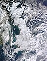 Photo: Jeff Schmaltz, MODIS Rapid Response Team, NASAA satellite photo of Great Britain and part of Ireland showing the extent of snow cover during the winter of 2009–2010, the coldest in Europe since 1981–82. Starting on 16 December 2009 a persistent weather pattern brought cold moist air from the north with systems undergoing cyclogenesis from North American storms moving across the Atlantic Ocean to the west, and saw many parts of Europe experiencing heavy snowfall and record low temperatures.
 -
 Photograph: Maull & Fox; restoration: Adam CuerdenFanny Bullock Workman (1859–1925) was an American geographer, cartographer, explorer, travel writer, and mountaineer. Together with her husband, William Hunter Workman, she traveled by bicycle through Switzerland, France, Italy, Spain, Algeria and India; after taking up climbing in the Himalayas, she set a women's altitude record on Pinnacle Peak, reaching 23,000 feet (7,000 m). She published eight travel books, with particular focus on the lives of women in the countries she visited, and championed women's rights and women's suffrage.
 -
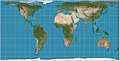 Map: Strebe, using GeocartThe Hobo–Dyer projection is a cylindrical equal-area projection commissioned in 2002 by Bob Abramms and Howard Bronstein. This projection was drafted by cartographer Mick Dyer, who based it on the 1910 Behrmann projection.
 -
 Map: Strebe, using GeocartThe Hammer retroazimuthal projection is a modified azimuthal proposed by Ernst Hermann Heinrich Hammer in 1910. As a retroazimuthal projection, azimuths (directions) are correct from any point to the designated center point. In whole-world presentation, the back and front hemispheres overlap, making the projection a surjective function. Here, the frontside and backside hemispheres, both with a 15° graticule and center point of 45°N, 90°W, are presented side-by-side.
 -
 Map: Strebe, using GeocartThe General Perspective projection is a map projection used in cartography in which the Earth is depicted as viewed from a finite distance above its surface. If the view precisely faces the center of the Earth, the projection is a vertical perspective projection; otherwise, it is a tilted perspective projection. Here is shown a vertical perspective from an altitude of 35,786 km over (0°, 90°W), corresponding to a view from geostationary orbit. Due to the horizon as seen from the viewpoint position, the projection always shows less than half of the Earth's surface: in this case neither of the North and South Poles is visible.
 -
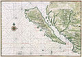 Map: Johannes Vingboons; Restoration: Lise BroerA c. 1650 map showing the Island of California, a long-held European misconception, dating from the 16th century, that California was not part of mainland North America but rather a large island separated from the continent by a strait now known instead as the Gulf of California. The belief persisted until the expeditions of Juan Bautista de Anza in 1774–76.
 -
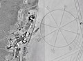 Photo credit: NASAThe world's largest compass rose, drawn on the desert floor at Edwards Air Force Base in California, United States. Painted on the dry lake near Dryden Flight Research Center, it is inclined to magnetic north and is used by pilots for calibrating heading indicators.
 -
 Map: Strebe, using GeocartThe Albers projection is a conic, equal area map projection, named after Heinrich C. Albers, that uses two standard parallels. Although scale and shape are not preserved, distortion is minimal between the standard parallels. This map is used by such agencies as the United States Geological Survey, the United States Census Bureau, and the governments of British Columbia and Yukon.
 -
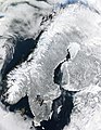 A satellite image of the Scandinavian Peninsula in winter. The peninsula, approximately 1,850 kilometers (1,150 miles) long with a width varying between approximately 370–805 km (230–500 mi), making it the largest in Europe, is located in the northern part of the continent and consists of Norway, Sweden and part of Finland. Much of the population is concentrated in the southern part of the peninsula; Stockholm and Gothenburg, both in Sweden, and Oslo in Norway are the largest cities.
 -
 Map credit: Robert WilkinsonAn 18th century map of the Iberian Peninsula illustrating various topographic features of the land. The Iberian Peninsula, or Iberia, is located in the extreme southwest of Europe, and includes modern day Spain, Portugal, Gibraltar and Andorra.
 -
 Map: Strebe, using GeocartThe Gall–Peters projection, named after James Gall and Arno Peters, is a specialization of a configurable equal-area map projection known as the cylindrical equal-area projection. It achieved considerable notoriety in the late 20th century as the centerpiece of a controversy surrounding the political implications of map design; Peters promoted it as a more faithful representation than the Mercator projection, which inflates the sizes of regions farther from the equator and thus makes the (mostly technologically underdeveloped) equatorial countries appear smaller and therefore, according to Peters, less significant.
 -
 Map: Strebe, using GeocartThe van der Grinten projection is a compromise map projection that is neither equal-area nor conformal. It projects the entire Earth into a circle, though the polar regions are subject to extreme distortion. The projection was the first of four proposed by Alphons J. van der Grinten in 1904, and, unlike perspective projections, is an arbitrary geometric construction on the plane. It was adopted as the National Geographic Society's reference map of the world from 1922 until 1988.
 -
 Map: Strebe, using GeocartThe sinusoidal projection is a pseudocylindrical equal-area map projection. Used as early as the 16th century, this projection shows distances accurately along the central meridian and the equator; areas furthest from these lines are the most distorted.
 -
 Image: Chris RywaltAn animation showing the unfolding of a Dymaxion map, a projection of a world map onto the surface of a polyhedron (in this case, an icosahedron) and then flattened to form a two-dimensional map which retains most of the relative proportional integrity of the globe map. This type of map was invented by Buckminster Fuller and is one of several of his inventions to use the name Dymaxion.
.jpg)


Featured biography
.jpg)
Sir Clements Robert Markham KCB FRS FRSGS (20 July 1830 – 30 January 1916) was an English geographer, explorer and writer. He was secretary of the Royal Geographical Society (RGS) between 1863 and 1888, and later served as the Society's president for a further 12 years. In the latter capacity he was mainly responsible for organising the British National Antarctic Expedition of 1901–1904, and for launching the polar career of Robert Falcon Scott.
Markham began his career as a Royal Navy cadet and midshipman, during which time he went to the Arctic with HMS Assistance in one of the many searches for Franklin's lost expedition. Later, Markham served as a geographer to the India Office, and was responsible for the collection of cinchona plants from their native Peruvian forests, and their transplantation in India. By this means, the Indian government acquired a home source from which quinine could be extracted. Markham also served as geographer to Sir Robert Napier's Abyssinian expeditionary force, and was present in 1868, at the fall of Magdala. (Full article...)More featured biographies
|
|---|
Did you know
- ... that Johann Reinhold Forster's 1778 book Observations Made During a Voyage Round the World has been described as "the beginning of modern geography"?
- ... that glaciation in Wisconsin 17 thousand years ago helped create its unique geography?
Places around you
Top 10 WikiProject Geography Popular articles of the month
-

A map of the United States showing its 50 states, federal district and five inhabited territories. Alaska, Hawaii, and the territories are shown at different scales, and the Aleutian Islands and the uninhabited northwestern Hawaiian Islands are omitted from this map.
The United States of America is a federal republic consisting of 50 states, a federal district (Washington, D.C., the capital city of the United States), five major territories, and various minor islands. Both the states and the United States as a whole are each sovereign jurisdictions. The Tenth Amendment to the United States Constitution allows states to exercise all powers of government not delegated to the federal government. Each state has its own constitution and government, and all states and their residents are represented in the federal Congress, a bicameral legislature consisting of the Senate and the House of Representatives. Each state is represented by two senators, while representatives are distributed among the states in proportion to the most recent constitutionally mandated decennial census. Additionally, each state is entitled to select a number of electors to vote in the Electoral College, the body that elects the president of the United States, equal to the total of representatives and senators in Congress from that state. The federal district does not have representatives in the Senate, but has a non-voting delegate in the House, and it is also entitled to electors in the Electoral College. Congress can admit more states, but it cannot create a new state from territory of an existing state or merge two or more states into one without the consent of all states involved, and each new state is admitted on an equal footing with the existing states. (Full article...) -
Earth is the third planet from the Sun and the only astronomical object known to harbor life. This is enabled by Earth being an ocean world, the only one in the Solar System sustaining liquid surface water. Almost all of Earth's water is contained in its global ocean, covering 70.8% of Earth's crust. The remaining 29.2% of Earth's crust is land, most of which is located in the form of continental landmasses within Earth's land hemisphere. Most of Earth's land is somewhat humid and covered by vegetation, while large sheets of ice at Earth's polar deserts retain more water than Earth's groundwater, lakes, rivers and atmospheric water combined. Earth's crust consists of slowly moving tectonic plates, which interact to produce mountain ranges, volcanoes, and earthquakes. Earth has a liquid outer core that generates a magnetosphere capable of deflecting most of the destructive solar winds and cosmic radiation. (Full article...) -
Generation Z (often shortened to Gen Z), colloquially known as Zoomers, is the demographic cohort succeeding Millennials and preceding Generation Alpha. Researchers and popular media use the mid-to-late 1990s as starting birth years and the early 2010s as ending birth years. Most members of Generation Z are the children of Generation X or older Millennials. (Full article...)
-

Google Maps is a web mapping platform and consumer application offered by Google. It offers satellite imagery, aerial photography, street maps, 360° interactive panoramic views of streets (Street View), real-time traffic conditions, and route planning for traveling by foot, car, bike, air (in beta) and public transportation. , Google Maps was being used by over one billion people every month around the world. (Full article...) -
Generation X (often shortened to Gen X) is the demographic cohort following the Baby Boomers and preceding Millennials. Researchers and popular media often use the mid-1960s as its starting birth years and the late 1970s as its ending birth years, with the generation being generally defined as people born from 1965 to 1980. By this definition and U.S. Census data, there are 65.2 million Gen Xers in the United States as of 2019. Most of Generation X are the children of the Silent Generation and early Baby Boomers; Xers are also often the parents of Millennials and Generation Z. (Full article...)
-

Hong Kong is a special administrative region of the People's Republic of China. With 7.4 million residents of various nationalities in a 1,104-square-kilometre (426 sq mi) territory, Hong Kong is one of the most densely populated territories in the world. (Full article...) -
London is the capital and largest city of both England and the United Kingdom, with a population of around 8.8 million, and its metropolitan area is the largest in Western Europe, with a population of 14.9 million. It stands on the River Thames in south-east England at the head of a 50-mile (80 km) estuary down to the North Sea and has been a major settlement for nearly two millennia. The City of London, its ancient core and financial centre, was founded by the Romans as Londinium and retains its medieval boundaries. The City of Westminster, to the west of the City of London, has for centuries hosted the national government and parliament. In the 19th century, London grew rapidly, becoming the world's largest city at the time, as it expanded and absorbed the surrounding county of Middlesex, and parts of Surrey and Kent. In 1965 it was combined with parts of Essex and Hertfordshire to create the administrative area of Greater London, which is governed by 33 local authorities and the Greater London Authority. (Full article...) -
Millennials, also known as Generation Y (often shortened to Gen Y), are the demographic cohort following Generation X and preceding Generation Z. Researchers and popular media use the early 1980s as starting birth years and the mid-1990s to early 2000s as ending birth years, with the generation typically being defined as people born from 1981 to 1996. Most Millennials are the children of Baby Boomers and older Generation X. In turn Millennials are often the parents of Generation Alpha. (Full article...)
-

Cartogram of the world's population in 2018; each square represents 500,000 people.
This is a list of countries and dependencies by population. It includes sovereign states, inhabited dependent territories and, in some cases, constituent countries of sovereign states, with inclusion within the list being primarily based on the ISO standard ISO 3166-1. For instance, the United Kingdom is considered a single entity, while the constituent countries of the Kingdom of the Netherlands are considered separately. In addition, this list includes certain states with limited recognition not found in ISO 3166-1. Also given in a percentage is each country's population compared with the world population, which the United Nations estimates at 8.11 billion as of 2024. (Full article...) -
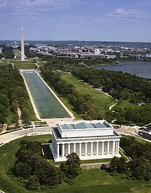
Washington, D.C., formally the District of Columbia and commonly called Washington or D.C., is the capital city and federal district of the United States. The city is on the Potomac River, across from Virginia, and shares land borders with Maryland to its north and east. Washington, D.C., was named for George Washington, a Founding Father and the first president of the United States. The district is named for Columbia, the female personification of the nation. (Full article...)

.jpg)

.jpeg)


Featured pictures


Main articles
 Categories
Associated Wikimedia
The following Wikimedia Foundation sister projects provide more on this subject:
-
 Commons
Free media repository -
 Wikibooks
Free textbooks and manuals -
 Wikidata
Free knowledge base -
 Wikinews
Free-content news -
 Wikiquote
Collection of quotations -
 Wikisource
Free-content library -
 Wikiversity
Free learning tools -
 Wikivoyage
Free travel guide -
 Wiktionary
Dictionary and thesaurus


