
Toubkal: Difference between revisions
No edit summary |
Rescuing 1 sources and tagging 0 as dead. #IABot (v1.6.1) (Balon Greyjoy) |
||
| Line 76: | Line 76: | ||
{{commons category}} |
{{commons category}} |
||
{{Wikivoyage|Jebel Toubkal}} |
{{Wikivoyage|Jebel Toubkal}} |
||
* [http://www.imlil.org/Toubkal.htm Routes up Mount Toubkal] |
* [https://web.archive.org/web/20100420002630/http://www.imlil.org/Toubkal.htm Routes up Mount Toubkal] |
||
* [http://www.summitpost.org/show/mountain_link.pl/mountain_id/50 Summitpost.org page about Jbel Toubkal] |
* [http://www.summitpost.org/show/mountain_link.pl/mountain_id/50 Summitpost.org page about Jbel Toubkal] |
||
* [http://www.caingram.info/Toubkal.htm Photo Gallery of Jebel Toubkal and the High Atlas] |
* [http://www.caingram.info/Toubkal.htm Photo Gallery of Jebel Toubkal and the High Atlas] |
||
Revision as of 11:31, 24 December 2017
| Toubkal توبقال ⵜⵓⴱⴽⴰⵍ | |
|---|---|
 Tizi-n-Tubkal from the summit ridge | |
| Highest point | |
| Elevation | 4,167 m (13,671 ft) |
| Prominence | 3,755 m (12,320 ft)[1] Ranked 36th |
| Listing | Country high point List of Ultras of Africa |
| Coordinates | 31°03′33″N 7°54′57″W / 31.05917°N 7.91583°W[1] |
| Geography | |
 Toubkal | |
| Parent range | Atlas Mountains |
| Topo map | Toubkal Massif Map and Guide[2] |
| Climbing | |
| First ascent | 12 June 1923 by the Marquis de Segonzac, V. Berger, and H. Dolbeau |
| Easiest route | South cwm (hike in summer) |
Toubkal or Tubkal (Arabic: توبقال Tūbqāl; Berber: ⵜⵓⴱⴽⴰⵍ Tubkal, or ⵜⵓⴱⵇⴰⵍ Tubqal) is a mountain peak in southwestern Morocco, located in the Toubkal National Park. At 4,167 metres (13,671 ft), it is the highest peak in the Atlas Mountains, Anti Atlas, North Africa and the Arab World. It is an ultra prominent peak located 63 km south of the city of Marrakesh, and is a popular destination for climbers.
Tourism

The first ascent by Europeans was on 12 June 1923 by the Marquis de Segonzac, Vincent Berger and Hubert Dolbeau, but the mountain may have been climbed before that date.[3]
Trekkers usually approach the mountain from the road-end village of Imlil. Qualified guides can be hired, as well as porters, to carry equipment and food supplies higher into the mountains. For experienced mountaineers, guides are not required for the normal route, as it is a moderate hike and orientation is not a problem.
The normal route starts with an easy walk to the village of Aroumd. Past Aroumd a floodplain is crossed and the route follows the left slope of the valley southwards. The valley bends to the east to the tiny settlement of Sidi Chamharouch, which has grown around a Muslim shrine. At Sidi Chamharouch, the path leads over the stream and runs steeply uphill to the right side of the Isougouane valley, which leads to two stone-built refuges (old Neltner Refuge and new Refuge du Toubkal) that are often used as base camp at 3,207 m (10,522 ft). It is possible to buy good meals in the Refuge du Toubkal. Tents can be pitched near the refuges for a small charge.
From that point a path crosses the stream, climbs a steep scree slope to the east and enters a valley (corrie), then climbs another steep slope to reach a col (Tizi'n'Toubkal at 3,940m). At the col the route turns left (northwards) to the summit ridge of Jbel Toubkal. The 4,167m summit is crowned with a curious pyramidal metal frame and views take in most of the Atlas and Little Atlas Mountains.
The ascent during the summer (from May) is non-technical yet moderately difficult, only complicated by steep and slippery scree slopes and altitude sickness. Sturdy boots and proper (windproof) clothing are required, and trekking poles are helpful on the scree. An ice-axe may be needed on the remaining snowfields in the early summer. The ascent during the end of the winter and spring (February/March) is more difficult. Crampons are necessary to ascend through the snow and - in some cases - ice.
It is possible to climb the mountain in two days - first day up to the refuge (around seven hours), second day to the summit (around five hours) and back to Imlil (up to five hours).
In summer the mountains can be very dry, but are sometimes subject to storms. Although the temperature should remain above zero during the day, freezing conditions are possible over 3,500m. In winter the mountains are covered in snow and ice, and can be prone to avalanches. Skiing is possible as the snow can lie to considerable depth and cover many rocky slopes. Information about the state of the route can be obtained at Marrakech tourist offices or at Imlil.

Gallery
-
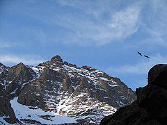 Birds soaring above the path to the summit
 -
 Jbel Toubkal in December 1930. Air photo taken by Swiss pilot and photographer Walter Mittelholzer.
 -
 Hikers midway to the summit
 -
 Hiker on toubkal
 -
 Spring water near the summit


See also
- Nearby villages of Asni, Ikkiss, Imlil and Tacheddirt.
References
- ^ a b "Africa Ultra-Prominences" Peaklist.org. Retrieved 2012-01-14.
- ^ Toubkal Massif Map and Guide (Map) (1st ed.). 1:160,000 with mountaineering information. High Atlas Mountains. Cartography by EWP. EWP and West Col Productions. 2008. ISBN 978-0-906227-98-5.
- ^ Robin G. Collomb, Atlas Mountains, Goring: West Col, 1980
External links
- Routes up Mount Toubkal
- Summitpost.org page about Jbel Toubkal
- Photo Gallery of Jebel Toubkal and the High Atlas
- Refuge information
| High Atlas |
|
|---|---|
| Middle Atlas |
|
| Anti-Atlas |
|
| Saharan Atlas |
|
| Rif |
|
| Other peaks & ranges | |