
Santa Fe, Cebu: Difference between revisions
use {{csvlist}}; resequence sections; improve wikilinks; ce |
add missing captions; move refs to end with undead link; corrections |
||
| Line 1: | Line 1: | ||
{{Infobox settlement |
{{Infobox settlement |
||
| name = Santa Fe |
| name = Santa Fe |
||
| |
| settlement_type = [[Municipalities of the Philippines|Municipality]] |
||
| |
| image_skyline = Ogtong beach area, Santa Fe.JPG |
||
| ⚫ | |||
| settlement_type = [[Municipalities of the Philippines|Municipality]] |
|||
| |
| image_caption = Og-tong beach area [[#Pooc|Pooc]], also showing Mayet and Yooneek resorts |
||
| |
| image_flag = {{#property:P41}} |
||
| flag_size = 120x80px |
|||
| image_caption = Og-tong beach area [[#Pooc|Pooc]], also showing Mayet and Yooneek resorts |
|||
| |
| flag_alt = |
||
| |
| image_seal = Santa Fe Cebu.png |
||
| |
| seal_size = 100x80px |
||
| |
| image_shield = |
||
| |
| shield_alt = |
||
| |
| nickname = |
||
| |
| motto = {{#property:P1451}} |
||
| |
| image_map = {{#property:P242}} |
||
| |
| map_caption = Map of {{#property:P131}} with Santa Fe highlighted |
||
| |
| pushpin_map = Philippines |
||
| ⚫ | |||
| ⚫ | |||
| ⚫ | |||
| ⚫ | |||
| ⚫ | |||
| latd = 11|latm = 09|latNS = N |
| latd = 11|latm = 09|latNS = N |
||
| longd = 123|longm = 49|longEW= E |
| longd = 123|longm = 49|longEW= E |
||
| coordinates_region = PH-CEB |
| coordinates_region = PH-CEB |
||
| coordinates_display = title,inline |
| coordinates_display = title,inline |
||
| coordinates_footnotes = |
| coordinates_footnotes = |
||
| coordinates_format = dms |
| coordinates_format = dms |
||
| subdivision_type = [[List of sovereign states|Country]] |
| subdivision_type = [[List of sovereign states|Country]] |
||
| subdivision_name = [[{{#property:P17}}]] |
| subdivision_name = [[{{#property:P17}}]] |
||
| subdivision_type1 = [[Regions of the Philippines|Region]] |
| subdivision_type1 = [[Regions of the Philippines|Region]] |
||
| subdivision_name1 = [[Central Visayas]] (Region VII) |
| subdivision_name1 = [[Central Visayas]] (Region VII) |
||
| subdivision_type2 = [[Provinces of the Philippines|Province]] |
| subdivision_type2 = [[Provinces of the Philippines|Province]] |
||
| subdivision_name2 = [[{{#property:P131}}]] |
| subdivision_name2 = [[{{#property:P131}}]] |
||
| subdivision_type3 = [[House of Representatives of the Philippines#District representation|District]] |
| subdivision_type3 = [[House of Representatives of the Philippines#District representation|District]] |
||
| subdivision_name3 = [[Legislative districts of Cebu#4th District|4th District]] |
| subdivision_name3 = [[Legislative districts of Cebu#4th District|4th District]] |
||
| established_title = Founded |
| established_title = Founded |
||
| established_date = {{csvlist|{{#property:P571}}}} |
| established_date = {{csvlist|{{#property:P571}}}} |
||
| parts_type = [[Barangay]] |
| parts_type = [[Barangay]] |
||
| parts = 10 (see § [[#Barangays|Barangays]]) |
| parts = 10 (see § [[#Barangays|Barangays]]) |
||
| government_footnotes = <ref>{{cite web |url=http://www.dilg.gov.ph/municipalities.php |title=Municipalities |publisher=Department of the Interior and Local Government |location=Quezon City, Philippines |accessdate=8 April 2013}}</ref> |
| government_footnotes = <ref>{{cite web |url=http://www.dilg.gov.ph/municipalities.php |title=Municipalities |publisher=Department of the Interior and Local Government |location=Quezon City, Philippines |accessdate=8 April 2013}}</ref> |
||
| leader_party = |
| leader_party = |
||
| leader_title = {{#property:P6}} |
| leader_title = {{#property:P6}} |
||
| leader_title1 = Vice {{#property:P6}} |
| leader_title1 = Vice {{#property:P6}} |
||
| leader_name = Jose "Titing" B. Esgana |
| leader_name = Jose "Titing" B. Esgana |
||
| area_total_km2 = 28.05 |
| area_total_km2 = 28.05 |
||
| area_footnotes = <ref name=nscb>{{cite web |title=Province: Cebu |url=http://www.nscb.gov.ph/activestats/psgc/province.asp?provCode=072200000&provName=CEBU®Code=07®Name=REGION%20VII%20(Central%20Visayas) |work=PSGC Interactive |publisher=National Statistical Coordination Board |accessdate=8 April 2013 |location=Makati City, Philippines}}</ref> |
| area_footnotes = <ref name=nscb>{{cite web |title=Province: Cebu |url=http://www.nscb.gov.ph/activestats/psgc/province.asp?provCode=072200000&provName=CEBU®Code=07®Name=REGION%20VII%20(Central%20Visayas) |work=PSGC Interactive |publisher=National Statistical Coordination Board |accessdate=8 April 2013 |location=Makati City, Philippines}}</ref> |
||
| population_total = {{#property:P1082}} |
| population_total = {{#property:P1082}} |
||
| population_as_of = {{#invoke:Wikidata|getQualifierDateValue|P1082|P585|FETCH_WIKIDATA|y}} |
| population_as_of = {{#invoke:Wikidata|getQualifierDateValue|P1082|P585|FETCH_WIKIDATA|y}} |
||
| population_density_km2 = auto |
| population_density_km2 = auto |
||
| population_demonym = {{csvlist|{{#property:P1549}}}} |
| population_demonym = {{csvlist|{{#property:P1549}}}} |
||
| population_footnotes = <ref name=NSO10 /> |
|||
| population_footnotes = <ref name=NSO10>{{cite web |url=http://www.census.gov.ph/sites/default/files/attachments/hsd/pressrelease/Central%20Visayas.pdf |title=Total Population by Province, City, Municipality and Barangay: as of May 1, 2010 |work=2010 Census of Population and Housing |publisher=National Statistics Office |accessdate=8 April 2013}}</ref> |
|||
| elevation_m = |
| elevation_m = |
||
| timezone = [[Time in the Philippines|PST]] |
| timezone = [[Time in the Philippines|PST]] |
||
| utc_offset = +8 |
| utc_offset = +8 |
||
| postal_code_type = [[List of ZIP codes in the Philippines|ZIP code]] |
| postal_code_type = [[List of ZIP codes in the Philippines|ZIP code]] |
||
| postal_code = {{#property:P281}} |
| postal_code = {{#property:P281}} |
||
| Line 79: | Line 78: | ||
| 2007= 26826 |
| 2007= 26826 |
||
| 2010= 27270 |
| 2010= 27270 |
||
| footnote= Source: National Statistics Office<ref name=NSO10/><ref name=NSO07 |
| footnote= Source: National Statistics Office<ref name=NSO10 /><ref name=NSO07 /> |
||
}} |
}} |
||
| Line 90: | Line 89: | ||
{| class="wikitable sortable" |
{| class="wikitable sortable" |
||
|- |
|- |
||
! {{abbr|PSGC|Philippines Standard Geographic Code}} !! style="width:160px; " | Name !! pop.<br />{{nowrap|<small>(2010)</small><ref name=NSO10 />}} !! pop.<br />{{nowrap|<small>( |
! {{abbr|PSGC|Philippines Standard Geographic Code}} !! style="width:160px; " | Name !! pop.<br />{{nowrap|<small>(2010)</small><ref name=NSO10 />}} !! pop.<br />{{nowrap|<small>(2007)</small><ref name="NSO07"/>}} || <abbr title="Per annum growth rate. Executive Order 135 §6 states that for "census years" (years divisible by 10) the reference date would be May 1st, but for all other years, the reference date is to be the "middle of the year". This means that growth rates, although correct, are not necessarily simple year-on-year comparisons.">±% p.a.</abbr> |
||
|- |
|- |
||
| 072244002 |
| 072244002 |
||
| Line 170: | Line 169: | ||
==References== |
==References== |
||
{{reflist|2 |
{{reflist|2|refs= |
||
<ref name=NSO07>{{cite web |
|||
| publisher = National Statistics Office |
|||
| url = http://www.census.gov.ph/data/census2007/h070000.pdf |
|||
| title=Population and Annual Growth Rates by Province, City and Municipality: Central Visayas: 1995, 2000 and 2007 |
|||
| archiveurl = http://web.archive.org/web/20110624035646/http://www.census.gov.ph/data/census2007/h070000.pdf |
|||
| archivedate = {{date|2011-06-24}} |
|||
}}</ref> |
|||
<ref name=NSO10>{{cite web |
|||
| url = http://www.census.gov.ph/sites/default/files/attachments/hsd/pressrelease/Central%20Visayas.pdf |
|||
| title = Total Population by Province, City, Municipality and Barangay: as of May 1, 2010 |
|||
| work = 2010 Census of Population and Housing |
|||
| publisher = National Statistics Office |
|||
| accessdate= {{date|8 April 2013}} |
|||
}}</ref> |
|||
}} |
|||
{{Commons category}} |
{{Commons category}} |
||
Revision as of 00:20, 25 January 2015
Santa Fe | |
|---|---|
 Og-tong beach area Pooc, also showing Mayet and Yooneek resorts | |
 Seal | |
 Map of Cebu with Santa Fe highlighted | |
| Country | Philippines |
| Region | Central Visayas (Region VII) |
| Province | Cebu |
| District | 4th District |
| Barangay | 10 (see § Barangays) |
| Government | |
| Area | |
| • Total | 28.05 km2 (10.83 sq mi) |
| Population (1903, 1918, 1939, 1948, 1960, 1970, 1975, 1980, 1990, 1995, 2000, 2007, 2010, 2015, 2020)[3] | |
| • Total | 34,471 |
| • Density | 1,200/km2 (3,200/sq mi) |
| Demonym | Santafehanon |
| Time zone | UTC+8 (PST) |
| ZIP code | 6047 |
| IDD : area code | +63 (0)32 |
| Income class | 4th class |
| PSGC | 072244000 |
Santa Fe is a fourth income class municipality in the province of Cebu, Philippines.[4] Template:Population census prose[3] The municipality's territory occupies the southeastern portion of Bantayan Island (marching with the municipality of Bantayan), together with the islands of Guintacan (or Kinatarkan), Hilantagaan and Hilantagaan Diot. Because the island's airport and principal ferry port are both located within the municipality, Santa Fe is considered the gateway to Bantayan and its islands.
Transport
Bantayan Airport, serving the whole Bantayan Island, is located in Santa Fe, although there are no scheduled flights. The town can also be reached by ferry from Hagnaya Wharf in San Remigio, Cebu.
Demographics
| Year | Pop. | ±% p.a. |
|---|---|---|
| 1990 | 20,838 | — |
| 1995 | 21,720 | +0.78% |
| 2000 | 22,956 | +1.19% |
| 2007 | 26,826 | +2.17% |
| 2010 | 27,270 | +0.60% |
| Source: National Statistics Office[3][5] | ||
Barangays
Santa Fe comprises 10 barangays:
|
| ||||||||||||||||||||||||||||||||||||||||||||||||||||||||||||||

Economy
Although there is some small-scale industry, the municipality's principal source of income is fishing and agriculture, and from holidaymakers who come in large numbers, most notably during Holy Week, to enjoy the particularly fine white sand and uncrowded beaches.
Image gallery
-
 Boat beached in Santa Fe
 -
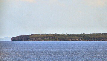 Guintacan Island; the 3 barangays of Hagdan, Kinatarkan and Langub are located on this island.
 -
 Ferry pier, Santa Fe


Notes
- ^ a b c The island of Guinatacan comprises the three barangays Hagdan, Kinatarkan, and Langub
- ^ Barangay comprises the islands of Hilantagaan and Hilantagaan Diot
References
- ^ "Municipalities". Quezon City, Philippines: Department of the Interior and Local Government. Retrieved 8 April 2013.
- ^ "Province: Cebu". PSGC Interactive. Makati City, Philippines: National Statistical Coordination Board. Retrieved 8 April 2013.
- ^ a b c d "Total Population by Province, City, Municipality and Barangay: as of May 1, 2010" (PDF). 2010 Census of Population and Housing. National Statistics Office. Retrieved 8 April 2013.
- ^ Philippine Income Classification for Provinces, Cities and Municipalities
- ^ a b "Population and Annual Growth Rates by Province, City and Municipality: Central Visayas: 1995, 2000 and 2007" (PDF). National Statistics Office. Archived from the original (PDF) on 24 June 2011.
Places adjacent to Santa Fe, Cebu | ||||||||||||||||
|---|---|---|---|---|---|---|---|---|---|---|---|---|---|---|---|---|
| ||||||||||||||||
Cebu City (capital and largest city) | |
| Municipalities |
|
| Component cities | |
| Highly urbanized cities | (Administratively independent from the province but grouped under Cebu by the Philippine Statistics Authority. However, qualified voters in Mandaue are allowed to vote in elections for Cebu provincial officials by virtue of Republic Act No. 6641, in accordance with Section 452-c of the Local Government Code of 1991.) |