Stonehenge, Avebury and Associated Sites: Difference between revisions
m →Avebury and Associated Monuments: WP:CHECKWIKI error fix for #48. Remove link to the title inside the text. Do general fixes if a problem exists. - using AWB (10539) |
Stonehenge sites map and expand lead, tidy up up external links |
||
| Line 27: | Line 27: | ||
}} |
}} |
||
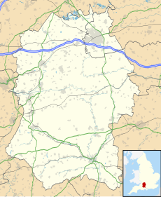
'''Stonehenge, Avebury and Associated Sites''' is a [[UNESCO]] [[World Heritage Site]] located in [[Wiltshire]], England. The WHS covers two large areas of land separated by nearly {{convert|30|mi|km}}, rather than a specific monument or building. The sites were inscribed as co-listings in 1986. |
'''Stonehenge, Avebury and Associated Sites''' is a [[UNESCO]] [[World Heritage Site]] located in [[Wiltshire]], England. The WHS covers two large areas of land separated by nearly {{convert|30|mi|km}}, rather than a specific monument or building. The sites were inscribed as co-listings in 1986. Some of the large and well know monuments within the WHS are listed below, but the area also has an exceptionally high density of small-scale archaeological sites, particularly from the prehistoric period. More than 700 individual archaeological features have been identified. There are 180 separate [[Scheduled Monument]]s, covering 415 items or features.<ref>[https://www.english-heritage.org.uk/publications/stonehenge-management-plan-2009/sh-manpan-1-2-screen.pdf Stonehenge Management Plan, 2009], English Heritage, p.22</ref> |
||
==Stonehenge and Associated Monuments== |
==Stonehenge and Associated Monuments== |
||
[[Image:Stonehenge back wide.jpg|thumb|Stonehenge]] |
[[Image:Stonehenge back wide.jpg|thumb|left|Stonehenge]] |
||
{{Location mark+ |
|||
| image = Stonehenge World Heritage Site map 2.svg |
|||
The Stonehenge area of the WHS is located in south Wiltshire. It covers an area of 26 square km and is centred on the prehistoric monument of [[Stonehenge]]. |
|||
| width = 260 |
|||
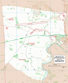
| caption = Boundary and key sites for the Stonehenge section of the Stonehenge and Avebury World Heritage Site |
|||
| alt = Map showing the boundary and key sites on the Stonehenge section of the [[Stonehenge, Avebury and Associated Sites|Stonehenge and Avebury]] [[World Heritage Site]] |
|||
| type = thumb |
|||
| float = right |
|||
| marks = |
|||
{{Location mark~| width = 260| font_size=80|label = [[Stonehenge|STONEHENGE]]| position = bottom| mark_alt = Stonehenge | mark_link = Stonehenge| x% =45 | y% = 41}} |
|||
{{Location mark~| width = 260| font_size=70|label = [[Stonehenge Cursus|Cursus]]| position = top| mark_alt = The Cursus| mark_link = Stonehenge Cursus| x% =46 | y% = 29}} |
|||
{{Location mark~| width = 260| font_size=70|label = [[Stonehenge Avenue|The Avenue]]| position = right| mark_alt = The Avenue| mark_link = Stonehenge Avenue| x% =59 | y% = 36}} |
|||
{{Location mark~| width = 260| font_size=70|label = [[Durrington Walls]]| position = left| mark_alt = Durrington Walls| mark_link = Durrington Walls| x% =91 | y% = 20}} |
|||
{{Location mark~| width = 260| font_size=70|label = [[Woodhenge]]| position = bottom| mark_alt = Woodhenge| mark_link = Woodhenge| x% =91 | y% = 24}} |
|||
{{Location mark~| width = 260| font_size=60|label = [[Vespasian's Camp]]| position = right| mark_alt = Vespasian's Camp| mark_link = Vespasian's Camp| x% =84 | y% = 46}} |
|||
{{Location mark~| width = 260| font_size=70|label = [[Normanton Down Barrows]]| position = right| mark_alt = Normanton Down Barrows| mark_link = Normanton Down Barrows| x% =48 | y% = 52}} |
|||
{{Location mark~| width = 260| font_size=60|label = [[Bluestonehenge]]| position = bottom| mark_alt = Bluestonehenge| mark_link = Bluestonehenge| x% =80 | y% = 50}} |
|||
{{Location mark~| width = 260| font_size=60|label = [[Stonehenge_Cursus#Lesser_Cursus|Lesser Cursus]]| position = bottom| mark_alt = Lesser Cursus| mark_link = Stonehenge_Cursus#Lesser_Cursus|Lesser Cursus| x% =15 | y% = 22}} |
|||
{{Location mark~| width = 260| font_size=60|label = [[New henge at Stonehenge|New Henge]]| position = left| mark_alt = New Henge| mark_link = New henge at Stonehenge| x% =32 | y% = 33}} |
|||
{{Location mark~| width = 260| font_size=60|label = King Barrow Ridge| position = right| mark_alt = King Barrow Ridge| mark_link = King Barrow Ridge| x% =67 | y% = 31}} |
|||
}} |
|||
The Stonehenge area of the WHS is located in south Wiltshire. It covers an area of 26 square km and is centred on the prehistoric monument of [[Stonehenge]]. Ownership is shared between [[English Heritage]], the [[National Trust]], the [[Ministry of Defence (United Kingdom)|Ministry of Defence]], the [[RSPB]], [[Wiltshire County Council|Wiltshire Council]], and private individuals and farmers. |
|||
===Monuments in the Stonehenge WHS=== |
===Monuments in the Stonehenge WHS=== |
||
| Line 42: | Line 61: | ||
*[[Woodhenge]] |
*[[Woodhenge]] |
||
*Coneybury Henge (a henge that has been ploughed flat<ref>http://www.themodernantiquarian.com/site/6727/coneybury_henge_site.html</ref>) |
*Coneybury Henge (a henge that has been ploughed flat<ref>http://www.themodernantiquarian.com/site/6727/coneybury_henge_site.html</ref>) |
||
*King Barrow Ridge<ref>http:// |
*King Barrow Ridge<ref>[http://services.english-heritage.org.uk/ResearchReportsPdfs/83_2011_WEB.pdf King Barrow Ridge Research report], English Heritage, 2011</ref> |
||
*[[Winterbourne Stoke Barrows]] |
*[[Winterbourne Stoke Barrows]] |
||
*[[Normanton Down Barrows]], including [[Bush Barrow]] |
*[[Normanton Down Barrows]], including [[Bush Barrow]] |
||
| Line 52: | Line 71: | ||
==Avebury and Associated Monuments== |
==Avebury and Associated Monuments== |
||
[[Image:Avebury henge and village UK.jpg|thumb|300px|Avebury Henge and Village]] |
[[Image:Avebury henge and village UK.jpg|thumb|left|300px|Avebury Henge and Village]] |
||
{{Location mark+ |
{{Location mark+ |
||
| image = Avebury World Heritage Site map.svg |
| image = Avebury World Heritage Site map.svg |
||
| Line 92: | Line 111: | ||
==External links== |
==External links== |
||
* [http://whc.unesco.org/en/list/373/ |
* [http://whc.unesco.org/en/list/373/ UNESCO: Stonehenge, Avebury and Associated Sites] |
||
* [http://www. |
* [http://www.stonehengeandaveburywhs.org/ Website of Stonehenge & Avebury World Heritage Site] |
||
* [http://www. |
* [http://www.english-heritage.org.uk/daysout/properties/avebury-alexander-keiller-museum/ Alexander Keiller Museum website] |
||
* [http://www.english-heritage.org.uk/server/show/nav.16322 Alexander Keiler Museum website] |
|||
* [http://www.salisburymuseum.org.uk/ Salisbury Museum website] |
* [http://www.salisburymuseum.org.uk/ Salisbury Museum website] |
||
* [http://www.wiltshireheritage.org.uk/ Wiltshire Heritage Museum website] |
* [http://www.wiltshireheritage.org.uk/ Wiltshire Heritage Museum website] |
||
Revision as of 21:09, 14 January 2015
| UNESCO World Heritage Site | |
|---|---|
| Criteria | Cultural: i, ii, iii |
| Reference | 373 |
| Inscription | 1986 (10th Session) |
Stonehenge, Avebury and Associated Sites is a UNESCO World Heritage Site located in Wiltshire, England. The WHS covers two large areas of land separated by nearly 30 miles (48 km), rather than a specific monument or building. The sites were inscribed as co-listings in 1986. Some of the large and well know monuments within the WHS are listed below, but the area also has an exceptionally high density of small-scale archaeological sites, particularly from the prehistoric period. More than 700 individual archaeological features have been identified. There are 180 separate Scheduled Monuments, covering 415 items or features.[1]
Stonehenge and Associated Monuments

The Stonehenge area of the WHS is located in south Wiltshire. It covers an area of 26 square km and is centred on the prehistoric monument of Stonehenge. Ownership is shared between English Heritage, the National Trust, the Ministry of Defence, the RSPB, Wiltshire Council, and private individuals and farmers.
Monuments in the Stonehenge WHS
- Stonehenge
- Stonehenge Avenue
- Stonehenge Cursus
- The Lesser Cursus
- Durrington Walls
- Woodhenge
- Coneybury Henge (a henge that has been ploughed flat[2])
- King Barrow Ridge[3]
- Winterbourne Stoke Barrows
- Normanton Down Barrows, including Bush Barrow
- Vespasian's Camp
- Robin Hood's Ball (an associated monument located just north of the WHS boundary)
- West Amesbury Henge, also known as Bluestonehenge
- Stonehenge Landscape
- Stonehenge New Henge
Avebury and Associated Monuments

The Avebury area of the WHS is located in northern Wiltshire. It covers an area of 22.5 square km and is centred on the prehistoric Avebury Henge.
Monuments in the Avebury WHS
- Avebury Henge
- West Kennet Avenue
- Beckhampton Avenue
- West Kennet Long Barrow
- The Sanctuary
- Silbury Hill
- Windmill Hill
Museum and archive collections
The main museums are the Alexander Keiler Museum, Salisbury Museum and Wiltshire Museum in Devizes
Other museums with material from Stonehenge and Avebury includes the British Museum, National Museum of Wales, Cambridge University Museum of Archaeology and Anthropology and the Ashmolean Museum. Other archives include the English Heritage Archive in Swindon, the Wiltshire and Swindon History Centre and the Bodleian Library.
Notes
- ^ Stonehenge Management Plan, 2009, English Heritage, p.22
- ^ http://www.themodernantiquarian.com/site/6727/coneybury_henge_site.html
- ^ King Barrow Ridge Research report, English Heritage, 2011


