
Tucson Mountains: Difference between revisions
No edit summary |
No edit summary |
||
| Line 69: | Line 69: | ||
File:Gates Pass Park1.JPG|[[Sonoran Desert]] vegetation at Gates Pass. |
File:Gates Pass Park1.JPG|[[Sonoran Desert]] vegetation at Gates Pass. |
||
File:Sunset over Tucson Mts.jpg|Sunset over the Tucson Mountains. |
File:Sunset over Tucson Mts.jpg|Sunset over the Tucson Mountains. |
||
File:Tumamoc_Hill_and_A_Mountain_from_Huerfano_Butte_area_2013.jpg|View across the Tucson Basin towards [[Tumamoc Hill]] (left) and [[Sentinel Peak (Arizona)|A Mountain]] (right), which can be seen in the center of the background. |
|||
</gallery> |
</gallery> |
||
Revision as of 22:19, 7 December 2013
The Tucson Mountains (O'odham language: Cuk Doʼag) are a minor mountain range west of Tucson, Arizona. The Tucson Mountains, including Wasson Peak, are one of four notable mountain ranges surrounding the Tucson Basin. The other ranges include the most prominent, the Santa Catalina Mountains, followed by the Rincon Mountains, and the Santa Rita Mountains.
Parks and preserves
The Arizona-Sonora Desert Museum is located on the west flank of the Tucson Mountains. Much of the range is protected by Saguaro National Park and Tucson Mountain County Park. Old Tucson Studios are located just west of the Tucson Mountains.
Tucson Mountain Park was established April 1929. The Pima County Parks Commission, with C. B. Brown as its chairman, was established to oversee the park. At approximately 20,000 acres (8,100 ha), the park is one of the largest natural resource areas owned and managed by a local government in the U.S. The park has approximately 62 miles (100 km) of non-motorized shared-use trails. The area is popular with hikers, mountain bikers, and equestrians.
Saguaro National Park was created as a National Monument in 1933 and later designated a national park in 1994.[1] The Tucson Mountain District of Saguaro National Park ranges from an elevation of 2,180 ft to 4,687 ft and contains 2 biotic communities, desert scrub, and desert grassland. Average annual precipitation is approximately 10.27 in. Common wildlife include the coyote, Gambel’s quail, and desert tortoise.[2]
Gallery
-
 Sonoran Desert vegetation at Gates Pass.
 -
 Sunset over the Tucson Mountains.
 -
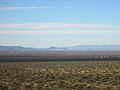 View across the Tucson Basin towards Tumamoc Hill (left) and A Mountain (right), which can be seen in the center of the background.


See also
References
- ^ "Saguaro National Park Fast Facts". National Parked. Retrieved 2010-12-30.
- ^ "Saguaro National Park - Nature & Science (U.S. National Park Service)". Nps.gov. 2007-06-22. Retrieved 2010-12-30.