
East Grinstead railway station: Difference between revisions
→Bluebell Railway: section |
→Bluebell Railway: adjust, add refs |
||
| Line 53: | Line 53: | ||
==Bluebell Railway== |
==Bluebell Railway== |
||
The heritage [[Bluebell Railway]] reopened part of the Lewes & East Grinstead Railway, from Sheffield Park to Horsted Keynes in 1960. Since obtaining planning permission in 1986, the Bluebell extended northwards, reaching |
The heritage [[Bluebell Railway]] reopened part of the Lewes & East Grinstead Railway, from Sheffield Park to Horsted Keynes in 1960. Since obtaining planning permission in 1986, the Bluebell extended northwards, reaching {{stnlnk|Kingscote}} in 1994. The Society has since been raising funds, purchasing land, and raising funds to remove the former 1970s domestic rubbish tip which filled Imberhorne Cutting, to link up with East Grinstead. |
||
In 1992, British Railway's offered to donate [[Imberhorne Viaduct]] to the Bluebell Railway Society. Further, in agreement with [[Sainsburys]], they offered for sale to the Society a piece of land just south of the existing station which had been used for carriage storage sidings since closure of the line to Sheffield Park and Lewes in the 1960s, big enough to enable the Society to construct a suitable terminal station for its own use and interconnection with [[Network Rail]].<ref name=SEM>{{cite web|url=http://www.semgonline.com/structures/struct_93.html|title=Imberhorne Viaduct|publisher=Semgonline.com|accessdate=10 February 2013}}</ref> |
|||
| ⚫ | The Bluebell station was completed in September 2010, located slightly south of the Network Rail station. Designed to repliace an authentic 1930's style Southern Railways station, it has a single platform capable of accommodating 8 coach trains, a [[run-round loop]] and a water tower is planned. Signalling will be controlled from {{stnlnk|Kingscote}}, although the Society will relocate an historic LB&SCR signalbox from {{stnlnk|Billingshurst}}.<ref name="bbrlwy">[http://www.bluebell-railway.co.uk/bluebell/ext/extprog.html#2aug12 Extension progress and Billingshurst Signalbox for East Grinstead]</ref> |
||
After rennovation of Imberhore Viaduct and relaying of trackworks south, through running to Network Rail started in July 2010, after [[GBRf]] had contracted to run occasional trains, each carrying 1,000 tons of excavated rubbish from Imberhorne Cutting to disposal sites, initially at [[Calvert, Buckinghamshire]].<ref>{{cite journal|last=White|first=Chris|date=Winter 2009|title=Viaduct work—and tip material to be removed by rail|journal=Bluebell News|publisher=Bluebell Railway|location=Sussex, England|volume=51|issue=4|pages=24–25}}</ref> The total to be removed was some 90,000 tons, achieved by December 2011. |
|||
[[File:View From Imberhorne Viaduct, East Grinstead (2) - geograph.org.uk - 1529156.jpg|thumb|right|250px|View from [[Imberhorne Viaduct]], looking north towards East Grinstead]] |
|||
| ⚫ | The Bluebell Railway station platform was again opened for the public on Saturday 4 September 2010 when a shuttle passenger service operated on |
||
| ⚫ | The Bluebell station was completed in September 2010, located slightly south of the Network Rail station. Designed to repliace an authentic 1930's style Southern Railways station, it has a single platform capable of accommodating 8 coach trains, a [[run-round loop]] and a water tower is planned. Signalling will be controlled from {{stnlnk|Kingscote}}, although the Society will relocate an historic LB&SCR signalbox from {{stnlnk|Billingshurst}}.<ref name="bbrlwy">[http://www.bluebell-railway.co.uk/bluebell/ext/extprog.html#2aug12 Extension progress and Billingshurst Signalbox for East Grinstead]</ref> |
||
| ⚫ | The Bluebell Railway moved former [[South West Trains]] [[British Rail Class 423|4VEP]] unit no. 3417 to the station site on 17 January 2009.<ref>[http://www.bluebell-railway.co.uk/bluebell/ext/extprog.html Bluebell Railway Extension Programme]</ref> The unit only remained on site for a few days as on 22 January it was moved to secure undercover storage at [[Eastleigh Works|Eastleigh Railway Works]]. The Bluebell Railway station platform was again opened for the public on Saturday 4 September 2010 when a shuttle passenger service operated on 4/5 September for about half a mile to the north end of the infilled cutting. The Bluebell Railway intend to commence services to East Grinstead on the weekend of 23–24 March 2013.{{cn|date=January 2013}} |
||
{{Rail start}} |
{{Rail start}} |
||
{{Rail line |previous={{rws|Dormans}}|route=[[Southern (train operating company)|Southern]]<br /><small>[[Oxted Line]]<br />East Grinstead branch</small> |col={{Southern colour}} }} |
{{Rail line |previous={{rws|Dormans}}|route=[[Southern (train operating company)|Southern]]<br /><small>[[Oxted Line]]<br />East Grinstead branch</small> |col={{Southern colour}} }} |
||
Revision as of 02:00, 18 February 2013
East Grinstead Low Level | |
|---|---|
| General information | |
| Location | Mid Sussex, West Sussex |
| Managed by | Southern |
| Platforms | 2 |
| Other information | |
| Station code | EGR |
| Key dates | |
| 1 August 1882 | Present station opened as East Grinstead Low Level[1] |
| ? | Renamed East Grinstead[1] |
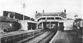
East Grinstead railway station serves the town of East Grinstead in West Sussex, England. The station was formerly divided into two levels: the higher level platforms serving the Three Bridges to Tunbridge Wells Central Line, whilst the lower level platforms received services from the Oxted Line 30+1⁄4 miles (48.7 km) south of London Victoria and the East Grinstead to Lewes Line.
Only the lower level platforms remain open today, the high level having closed in 1967 following the withdrawal of the Three Bridges Line as part of the closure programme proposed by the Beeching Report.[2] A third low-level platform has been constructed at the south of the station by the Bluebell railway.
Low Level
History
The current East Grinstead station is the fourth to have been constructed in the town. The first was opened on 9 July 1855[1] in Swan Mead off the London Road. It was the terminus of a 6 mile long line to Three Bridges. Constructed at a cost of £3,000, the station comprised a sandstone main building which survives to this day, as well as timber goods and engine sheds which had slate roofs. The first stationmaster was a Mr Peter Nesbitt; he remained in post until his death on 10 October 1864. In 1861 parliamentary approval was obtained for the extension of the Three Bridges Line to Tunbridge Wells. The extension required East Grinstead station to be relocated a few yards north at a lower level in order to allow the line to pass under London Road. The new station building straddled the double track with basements at platform level which contained the stationmaster's office and porter's room. A large brick goods shed replaced the previous timber structure, whilst the site of the old station became a goods yard. The new station was opened for traffic on 1 October 1866, and the old one closed the same day.[1][3]
The third re-modelling of East Grinstead station was made necessary by the arrival of two lines. First, the arrival from the south of an extension of the Lewes and East Grinstead Railway (L&EG) on 1 August 1882, which was followed on 10 March 1884, by an extension from the north of the Croydon, Oxted and East Grinstead Railway (CO&EG). The L&EG would approach the Three Bridges line from the south at a right angle and the CO&EG would make an end-on junction with it. In order to accommodate the L&EG the 1866 station would have to be enlarged and modified, entailing the purchase of the adjoining timber yard. The railway company was not prepared to go to this expense and instead decided to relocate the station 300 yards to the west.
The new station was opened to traffic on 1 August 1882;[1] and the old one closed on 15 October 1883.[1] It was arranged on two levels: the higher equipped with two island platforms serving four tracks on the Three Bridges Line, the lower a double line two-platformed station set at a right angle to the L&EG. A sharply curving spur line (later known as the "St. Margaret's Loop") would enter the high level station from the CO&EG, requiring a deviation of the Three Bridges Line on its western approach to the new station in order to ease the sharpness of the bend. In 1907 the entire structure of the 1866 station was sold for scrap for £15.[4] The High Level station closed on 2 January 1967[1] with the Three Bridges to Tunbridge Wells line.
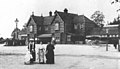
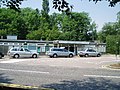
In February 1970 after the closure of the High Level station British Rail carried out a remodelling of the station, replacing the old station building with a smaller modern construction which reflected its new status as the terminus of a branch line from Oxted.[4]. Accordingly the "Low Level" name was therefore dropped. In early 2013 this building was demolished, having been replaced with a new one. [1]
Facilities
- Booking Hall
- Ticket Office (2 Windows)
- Quick Ticket
- Station Kiosk
- Photo Booth
- Toilets
- Car Park
- Bicycle Storage
- Taxi rank
Services
The typical off-peak service is two trains per hour to London Victoria.
Bluebell Railway
The heritage Bluebell Railway reopened part of the Lewes & East Grinstead Railway, from Sheffield Park to Horsted Keynes in 1960. Since obtaining planning permission in 1986, the Bluebell extended northwards, reaching Kingscote in 1994. The Society has since been raising funds, purchasing land, and raising funds to remove the former 1970s domestic rubbish tip which filled Imberhorne Cutting, to link up with East Grinstead.
In 1992, British Railway's offered to donate Imberhorne Viaduct to the Bluebell Railway Society. Further, in agreement with Sainsburys, they offered for sale to the Society a piece of land just south of the existing station which had been used for carriage storage sidings since closure of the line to Sheffield Park and Lewes in the 1960s, big enough to enable the Society to construct a suitable terminal station for its own use and interconnection with Network Rail.[5]
After rennovation of Imberhore Viaduct and relaying of trackworks south, through running to Network Rail started in July 2010, after GBRf had contracted to run occasional trains, each carrying 1,000 tons of excavated rubbish from Imberhorne Cutting to disposal sites, initially at Calvert, Buckinghamshire.[6] The total to be removed was some 90,000 tons, achieved by December 2011.
_-_geograph.org.uk_-_1529156.jpg)
The Bluebell station was completed in September 2010, located slightly south of the Network Rail station. Designed to repliace an authentic 1930's style Southern Railways station, it has a single platform capable of accommodating 8 coach trains, a run-round loop and a water tower is planned. Signalling will be controlled from Kingscote, although the Society will relocate an historic LB&SCR signalbox from Billingshurst.[7]
The Bluebell Railway moved former South West Trains 4VEP unit no. 3417 to the station site on 17 January 2009.[8] The unit only remained on site for a few days as on 22 January it was moved to secure undercover storage at Eastleigh Railway Works. The Bluebell Railway station platform was again opened for the public on Saturday 4 September 2010 when a shuttle passenger service operated on 4/5 September for about half a mile to the north end of the infilled cutting. The Bluebell Railway intend to commence services to East Grinstead on the weekend of 23–24 March 2013.[citation needed]
| Preceding station | Following station | |||
|---|---|---|---|---|
| Dormans | Southern Oxted Line East Grinstead branch |
Terminus | ||
| Terminus | Bluebell Railway | Imberhorne North | ||
| Terminus | Bluebell Railway From 2013 |
Kingscote | ||
| Disused railways | ||||
| Terminus | London, Brighton and South Coast Railway Lewes and East Grinstead Railway |
Kingscote | ||
High Level
East Grinstead High Level | |
|---|---|
| General information | |
| Location | Mid Sussex, West Sussex |
| Owned by | Southern Railway Southern Region of British Railways |
| Managed by | London, Brighton and South Coast Railway |
| Platforms | 4 |
| Key dates | |
| 1 August 1882 | Opened |
| 2 January 1967 | Closed to passengers |
| 10 April 1967 | Closed to freight |
Opened on 1 August 1882,[1] the timber accommodation provided for the High Level station was not as comfortable as that in the Lower Level station. It was, however, equipped with a refreshment room on each platform, as well as two signal cabins on either side - East Grinstead West and East Grinstead East. A private siding also led into Stenning's adjoining timber yard. The first train to use the station was a 05:50 service from Three Bridges to Brighton via East Grinstead.[3]
The closure of the Three Bridges-Groombridge Line after the last train on Sunday 1 January 1967 spelt the end for the High Level station which would receive no further traffic. The goods yard had been virtually closed for some time except for coal, and all freight facilities were formally withdrawn as from 10 April. The last train to use the station in February 1968 was a tracklifting train hauled by a Class 33 diesel locomotive. Until its demolition in 1970, the station was used by passengers as a short-cut to the Low Level which saved them the trouble of going around a nearby housing estate. Protests from passengers at the loss of the short-cut led to British Rail erecting a footbridge. The goods yard area was taken over by the A22 which runs parallel with Railway Approach. The East Grinstead Society had attempted to save the brick goods shed for reuse as a drama and arts workshop, but were unable to secure the necessary funds.[3]
Future
Work started in Autumn 2008 on site clearance work for the construction of a new separate single platform station for the Bluebell Railway for their extension northwards from Kingscote. This station is approx 100 yards south of the existing National Rail station. The section of line to Kingscote is planned to reopen in 2013.
With regard to the possible reopening of the remaining section of the line from Tunbridge Wells to Three Bridges, a number of obstacles would appear to stand in the way of such action, most notably:
1) An industrial site currently occupies the former location of Forest Row railway station as well as a small recycling centre to west.
2) The formation has been built across in several places notably in East Grinstead where about one mile of the trackbed from Station Road to the Lewes Road tunnel has been taken over for a relief road (the A22 ironically named "Beeching Way" after Richard Beeching whose recommendations closed the railway line). As there is no feasible alternative route into the station, this road would need to be reconverted back to rail. Any such action would in all likelihood result in a cut in capacity on an already highly congested road network.
3) The site of Grange Road has disappeared under a small parade of shops as well as housing which block 0.64 miles of the formation.
4) In 1974 East Sussex County Council created the Forest Way linear Country Park using the trackbed of the line from East Grinstead (just to the east of "Beeching Way") as far as Groombridge. Similarly, in 1979 West Sussex County Council created the Worth Way linear Country Park using the disused Three Bridges to East Grinstead line. Both have now been incorporated in to the Sustrans National Cycle Network.
| Preceding station | Disused railways | Following station | ||
|---|---|---|---|---|
| Grange Road | British Rail Southern Region Three Bridges to Tunbridge Wells Central Line |
Forest Row |
Gallery
-
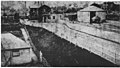 Only surviving picture of 1855 station
 -
 1866 station
 -
 1883 station
 -
 1970 CLASP station


References
- ^ a b c d e f g h Butt, R.V.J. (1995). The Directory of Railway Stations. Yeovil: Patrick Stephens Ltd. p. 88. ISBN 1-85260-508-1. R508.
{{cite book}}: Invalid|ref=harv(help) - ^ East Grinstead High Level railway station on Subterranea Britannica
- ^ a b c Gould, David (1983). Three Bridges to Tunbridge Wells. The Oakwood Press. ISBN 978-0-85361-299-5.
- ^ a b Mitchell, Vic (1984). Branch Lines to East Grinstead. Midhurst, West Sussex: Middleton Press. ISBN 090652007.
{{cite book}}: Check|isbn=value: length (help); Unknown parameter|coauthors=ignored (|author=suggested) (help) - ^ "Imberhorne Viaduct". Semgonline.com. Retrieved 10 February 2013.
- ^ White, Chris (Winter 2009). "Viaduct work—and tip material to be removed by rail". Bluebell News. 51 (4). Sussex, England: Bluebell Railway: 24–25.
- ^ Extension progress and Billingshurst Signalbox for East Grinstead
- ^ Bluebell Railway Extension Programme
External links
- Train times and station information for East Grinstead railway station from National Rail
- East Grinstead Museum
- East Grinstead Society