Safien: Difference between revisions
Ptbotgourou (talk | contribs) m r2.7.2) (Robot: Adding uz:Safien |
update for merger |
||
| Line 3: | Line 3: | ||
| image_photo = Safien Platz.jpg |
| image_photo = Safien Platz.jpg |
||
| municipality_name = Safien |
| municipality_name = Safien |
||
| municipality_type = |
| municipality_type = former |
||
| imagepath_coa = Safien wappen.svg|pixel_coa= |
| imagepath_coa = Safien wappen.svg|pixel_coa= |
||
| map = |
| map = |
||
| Line 15: | Line 15: | ||
| area = 100.6 |
| area = 100.6 |
||
| elevation = 1315|elevation_description= |
| elevation = 1315|elevation_description= |
||
| population = |
| population = 294 | populationof = Dec 2011 | popofyear = 2011 |
||
| website = www.safien.ch |
| website = www.safien.ch |
||
| mayor = |mayor_asof=|mayor_party= |
| mayor = |mayor_asof=|mayor_party= |
||
| Line 24: | Line 24: | ||
| twintowns = [[Bettingen]] (Switzerland) |
| twintowns = [[Bettingen]] (Switzerland) |
||
|}} |
|}} |
||
'''Safien''' is a [[Municipalities of Switzerland|municipality]] in the district of [[Surselva (district)|Surselva]] in the [[Switzerland|Swiss]] [[Cantons of Switzerland|canton]] of [[Graubünden]]. |
|||
'''Safien''' is a former [[Municipalities of Switzerland|municipality]] in the district of [[Surselva (district)|Surselva]] in the [[Switzerland|Swiss]] [[Cantons of Switzerland|canton]] of [[Graubünden]]. The municipalities of [[Valendas]], [[Versam]], Safien and [[Tenna, Switzerland|Tenna]] merged on 1 January 2013 into the new municipality of [[Safiental]].<ref name=Fusion>[http://www.bfs.admin.ch/bfs/portal/de/index/infothek/nomenklaturen/blank/blank/gem_liste/03.html Amtliches Gemeindeverzeichnis der Schweiz] published by the Swiss Federal Statistical Office {{de icon}} accessed 2 January 2013</ref> |
|||
==History== |
==History== |
||
| Line 31: | Line 32: | ||
==Geography== |
==Geography== |
||
[[File:Thalkirch Kirche Postauto.jpg|thumb|left|Thalkirch church, Safien]] |
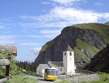
[[File:Thalkirch Kirche Postauto.jpg|thumb|left|Thalkirch church, Safien]] |
||
Safien |
Safien had an area, {{as of|2006|lc=on}}, of {{convert|100.6|km2|sqmi|abbr=on}}. Of this area, 45.6% is used for agricultural purposes, while 18.2% is forested. Of the rest of the land, 0.8% is settled (buildings or roads) and the remainder (35.4%) is non-productive (rivers, glaciers or mountains).<ref name=SFSO/> |
||
The municipality |
The former municipality was the capital of the Safien sub-district of the Surselva district in the mid and upper Safien valley. The only other municipality in the sub-district is [[Tenna, Switzerland|Tenna]], which occupies the lower Safien valley. The valley is drained by the [[Rabiusa]] river. |
||
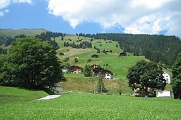
The municipality consists of the village of Safien-Platz (elevation: {{convert|1350|m|ft|abbr=on}}) and scattered [[hamlet (place)|hamlets]] and single farm houses throughout the valley. |
The former municipality consists of the village of Safien-Platz (elevation: {{convert|1350|m|ft|abbr=on}}) and scattered [[hamlet (place)|hamlets]] and single farm houses throughout the valley. |
||
==Coat of arms== |
==Coat of arms== |
||
| Line 41: | Line 42: | ||
==Demographics== |
==Demographics== |
||
Safien |
Safien had a population (as of 2011) of 294.<ref name="SFSO_2011">[http://www.pxweb.bfs.admin.ch/Dialog/varval.asp?ma=px-d-01-2A01&ti=St%E4ndige+und+Nichtst%E4ndige+Wohnbev%F6lkerung+nach+Region%2C+Geschlecht%2C+Nationalit%E4t+und++Alter&path=../Database/German_01%20-%20Bev%F6lkerung/01.2%20-%20Bev%F6lkerungsstand%20und%20-bewegung/&lang=1&prod=01&openChild=true&secprod=2 Swiss Federal Statistics Office – STAT-TAB] ''Ständige und Nichtständige Wohnbevölkerung nach Region, Geschlecht, Nationalität und Alter'' {{de icon}} accessed 3 October 2012</ref> {{as of|2008}}, 0.3% of the population was made up of foreign nationals.<ref name=Population/> Over the last 10 years the population has decreased at a rate of -15%. Most of the population ({{as of|2000|lc=on}}) speaks German (96.1%), with Italian being second most common ( 1.6%) and Albanian being third ( 1.6%).<ref name=SFSO>[http://www.bfs.admin.ch/bfs/portal/en/index/regionen/02/key.html Swiss Federal Statistical Office] accessed 02-Dec-2009</ref> |
||
{{as of|2000}}, the gender distribution of the population was 49.5% male and 50.5% female.<ref name=GR_Numbers>[http://www.gr.ch/DE/institutionen/verwaltung/dvs/awt/dienstleistungen/volkswirtschaftlichegrundlagen/Seiten/default.aspx Graubunden in Numbers] {{de icon}} accessed 21 September 2009</ref> The age distribution, {{as of|2000|lc=on}}, in Safien is; 49 children or 15.9% of the population are between 0 and 9 years old and 43 teenagers or 14.0% are between 10 and 19. Of the adult population, 24 people or 7.8% of the population are between 20 and 29 years old. 37 people or 12.0% are between 30 and 39, 39 people or 12.7% are between 40 and 49, and 36 people or 11.7% are between 50 and 59. The senior population distribution is 30 people or 9.7% of the population are between 60 and 69 years old, 28 people or 9.1% are between 70 and 79, there are 18 people or 5.8% who are between 80 and 89,and there are 4 people or 1.3% who are between 90 and 99.<ref name=Population>[http://www.gr.ch/DE/institutionen/verwaltung/dvs/awt/dienstleistungen/volkswirtschaftlichegrundlagen/Seiten/Bevoelkerung.aspx Graubunden Population Statistics] {{de icon}} accessed 21 September 2009</ref> |
{{as of|2000}}, the gender distribution of the population was 49.5% male and 50.5% female.<ref name=GR_Numbers>[http://www.gr.ch/DE/institutionen/verwaltung/dvs/awt/dienstleistungen/volkswirtschaftlichegrundlagen/Seiten/default.aspx Graubunden in Numbers] {{de icon}} accessed 21 September 2009</ref> The age distribution, {{as of|2000|lc=on}}, in Safien is; 49 children or 15.9% of the population are between 0 and 9 years old and 43 teenagers or 14.0% are between 10 and 19. Of the adult population, 24 people or 7.8% of the population are between 20 and 29 years old. 37 people or 12.0% are between 30 and 39, 39 people or 12.7% are between 40 and 49, and 36 people or 11.7% are between 50 and 59. The senior population distribution is 30 people or 9.7% of the population are between 60 and 69 years old, 28 people or 9.1% are between 70 and 79, there are 18 people or 5.8% who are between 80 and 89,and there are 4 people or 1.3% who are between 90 and 99.<ref name=Population>[http://www.gr.ch/DE/institutionen/verwaltung/dvs/awt/dienstleistungen/volkswirtschaftlichegrundlagen/Seiten/Bevoelkerung.aspx Graubunden Population Statistics] {{de icon}} accessed 21 September 2009</ref> |
||
| Line 85: | Line 86: | ||
*[http://www.safien.ch Official website (in German)] |
*[http://www.safien.ch Official website (in German)] |
||
[[Category:Villages in Graubünden]] |
|||
{{Municipalities of the district of Surselva}} |
|||
[[ca:Safien]] |
[[ca:Safien]] |
||
Revision as of 14:34, 4 January 2013
Safien | |
|---|---|
 | |
| Country | Switzerland |
| Canton | Graubünden |
| District | Surselva |
| Area | |
| • Total | 100.58 km2 (38.83 sq mi) |
| Elevation | 1,315 m (4,314 ft) |
| Population (Dec 2011) | |
| • Total | 294 |
| • Density | 2.9/km2 (7.6/sq mi) |
| Time zone | UTC+01:00 (Central European Time) |
| • Summer (DST) | UTC+02:00 (Central European Summer Time) |
| Postal code(s) | 7107 |
| SFOS number | 3651 |
| ISO 3166 code | CH-GR |
| Surrounded by | Casti-Wergenstein, Duvin, Flerden, Mathon, Nufenen, Pitasch, Portein, Präz, Riein, Sankt Martin, Sarn, Splügen, Sufers, Tenna, Tschappina, Vals |
| Twin towns | Bettingen (Switzerland) |
| Website | www SFSO statistics |
Safien is a former municipality in the district of Surselva in the Swiss canton of Graubünden. The municipalities of Valendas, Versam, Safien and Tenna merged on 1 January 2013 into the new municipality of Safiental.[1]
History
Safien is first mentioned in 1219 as Stosavia.[2]
Geography

Safien had an area, as of 2006[update], of 100.6 km2 (38.8 sq mi). Of this area, 45.6% is used for agricultural purposes, while 18.2% is forested. Of the rest of the land, 0.8% is settled (buildings or roads) and the remainder (35.4%) is non-productive (rivers, glaciers or mountains).[3]
The former municipality was the capital of the Safien sub-district of the Surselva district in the mid and upper Safien valley. The only other municipality in the sub-district is Tenna, which occupies the lower Safien valley. The valley is drained by the Rabiusa river.
The former municipality consists of the village of Safien-Platz (elevation: 1,350 m (4,430 ft)) and scattered hamlets and single farm houses throughout the valley.
Coat of arms
The blazon of the municipal coat of arms is Gules a Cross gyronny Argent and Sable[4] It is based on the simple design of the sub-district, with different colors.
Demographics
Safien had a population (as of 2011) of 294.[5] As of 2008[update], 0.3% of the population was made up of foreign nationals.[6] Over the last 10 years the population has decreased at a rate of -15%. Most of the population (as of 2000[update]) speaks German (96.1%), with Italian being second most common ( 1.6%) and Albanian being third ( 1.6%).[3]
As of 2000[update], the gender distribution of the population was 49.5% male and 50.5% female.[7] The age distribution, as of 2000[update], in Safien is; 49 children or 15.9% of the population are between 0 and 9 years old and 43 teenagers or 14.0% are between 10 and 19. Of the adult population, 24 people or 7.8% of the population are between 20 and 29 years old. 37 people or 12.0% are between 30 and 39, 39 people or 12.7% are between 40 and 49, and 36 people or 11.7% are between 50 and 59. The senior population distribution is 30 people or 9.7% of the population are between 60 and 69 years old, 28 people or 9.1% are between 70 and 79, there are 18 people or 5.8% who are between 80 and 89,and there are 4 people or 1.3% who are between 90 and 99.[6]
In the 2007 federal election the most popular party was the SVP which received 62.4% of the vote. The next three most popular parties were the SP (18.8%), the FDP (7.4%) and the CVP (5.4%).[3]
In Safien about 61.7% of the population (between age 25-64) have completed either non-mandatory upper secondary education or additional higher education (either university or a Fachhochschule).[3]
Safien has an unemployment rate of 0.46%. As of 2005[update], there were 89 people employed in the primary economic sector and about 35 businesses involved in this sector. 15 people are employed in the secondary sector and there are 3 businesses in this sector. 32 people are employed in the tertiary sector, with 12 businesses in this sector.[3]
The historical population is given in the following table:[2]
| year | population |
|---|---|
| 1803 | 770 |
| 1850 | 685 |
| 1900 | 455 |
| 1950 | 453 |
| 2000 | 308 |
| 2010 | 305 |
References
- ^ Amtliches Gemeindeverzeichnis der Schweiz published by the Swiss Federal Statistical Office Template:De icon accessed 2 January 2013
- ^ a b Safien in German, French and Italian in the online Historical Dictionary of Switzerland.
- ^ a b c d e Swiss Federal Statistical Office accessed 02-Dec-2009
- ^ Flags of the World.com accessed 02-Dec-2009
- ^ Swiss Federal Statistics Office – STAT-TAB Ständige und Nichtständige Wohnbevölkerung nach Region, Geschlecht, Nationalität und Alter Template:De icon accessed 3 October 2012
- ^ a b Graubunden Population Statistics Template:De icon accessed 21 September 2009
- ^ Graubunden in Numbers Template:De icon accessed 21 September 2009


