
Brook Street, London: Difference between revisions
→External links: dmoz |
|||
| Line 18: | Line 18: | ||
* 13 Avery Row: [[W. H. Davies]] - Welsh tramp-poet. |
* 13 Avery Row: [[W. H. Davies]] - Welsh tramp-poet. |
||
| ⚫ | |||
*[http://www.mayfair-london.co.uk/brook_street.htm Brook Street in Mayfair] |
|||
* [http://www.streetmap.co.uk/newmap.srf?x=528250&y=180750&z=1&sv=528250,180750&st=4&ar=N&mapp=newmap.srf&searchp=newsearch.srf&ax=528813&ay=181022 Map] |
|||
* [http://www.british-history.ac.uk/report.asp?compid=42099 Brook Street] — detailed architectural history of Brook Street from the ''[[Survey of London]]'' |
* [http://www.british-history.ac.uk/report.asp?compid=42099 Brook Street] — detailed architectural history of Brook Street from the ''[[Survey of London]]'' |
||
* [http://www.british-history.ac.uk/report.asp?compid=42139 Upper Brook Street] — detailed architectural history of Upper Brook Street from the ''[[Survey of London]]'' |
* [http://www.british-history.ac.uk/report.asp?compid=42139 Upper Brook Street] — detailed architectural history of Upper Brook Street from the ''[[Survey of London]]'' |
||
==Gallery== |
|||
<gallery> |
<gallery> |
||
Image:Blue plaque Hendrix.jpg|Jimi Hendrix, 23 Brook Street |
Image:Blue plaque Hendrix.jpg|Jimi Hendrix, 23 Brook Street |
||
| Line 29: | Line 26: | ||
Image:Blue Plaque to Colen Campbell.jpg|Colen Campbell, 76 Brook Street |
Image:Blue Plaque to Colen Campbell.jpg|Colen Campbell, 76 Brook Street |
||
</gallery> |
</gallery> |
||
| ⚫ | |||
<!--======================== {{No more links}} ============================ |
|||
| PLEASE BE CAUTIOUS IN ADDING MORE LINKS TO THIS ARTICLE. Wikipedia | |
|||
| is not a collection of links nor should it be used for advertising. | |
|||
| | |
|||
| Excessive or inappropriate links WILL BE DELETED. | |
|||
| See [[Wikipedia:External links]] & [[Wikipedia:Spam]] for details. | |
|||
| | |
|||
| If there are already plentiful links, please propose additions or | |
|||
| replacements on this article's discussion page, or submit your link | |
|||
| to the relevant category at the Open Directory Project (dmoz.org) | |
|||
| and link back to that category using the {{dmoz}} template. | |
|||
======================= {{No more links}} =============================--> |
|||
* {{dmoz|/Regional/Europe/United_Kingdom/England/London/Westminster/}} |
|||
{{coord|51.5129|-0.1471|type:landmark_region:GB-WSM|display=title}} |
{{coord|51.5129|-0.1471|type:landmark_region:GB-WSM|display=title}} |
||
Revision as of 14:42, 8 November 2010

Brook Street is one of the principal streets on the Grosvenor Estate in the exclusive central London district of Mayfair. It was developed in the first half of the 18th century and runs from Hanover Square to Grosvenor Square. The continuation from Grosvenor Square to Park Lane is called Upper Brook Street. Both sections originally consisted of typical London terraced houses, mostly built to individual designs. Some of them are quite grand and were designed by well known architects for aristocratic clients, especially near Grosvenor Square, while others are more modest. Some of the original houses survive while others have been replaced by buildings from a variety of periods.
Features of the street include the grand hotel Claridge's, at the junction with Davies Street, and Le Gavroche, a famous restaurant. The United States Embassy, which abuts Upper Brook Street and Grosvenor Square, has necessitated security arrangements which impede free access to the former. The Handel House Museum is also in Brook Street. A curiosity is the placing of two blue plaques on adjoining houses, numbers 23 and 25, both for famous musicians.
.jpg)
Former residents:
- 23 Brook Street: Jimi Hendrix — guitarist
- 25 Brook Street: Georg Frideric Handel — composer - now the Handel House Museum
- 39 Brook Street: Sir Jeffry Wyatville — architect
- 74 Brook Street: Sir William Withey Gull - physician (Jack the Ripper suspect)
- 76 Brook Street: Colen Campbell — architect
- 22 Upper Brook Street: Leo Bonn — founder of what is now the Royal National Institute for Deaf People.
- 51 Upper Brook Street: George Seferis — Greek Ambassador, poet and Nobel Laureate
- 13 Avery Row: W. H. Davies - Welsh tramp-poet.
- Brook Street — detailed architectural history of Brook Street from the Survey of London
- Upper Brook Street — detailed architectural history of Upper Brook Street from the Survey of London
Gallery
-
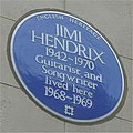 Jimi Hendrix, 23 Brook Street
 -
 George Frideric Handel, 25 Brook Street
 -
 Colen Campbell, 76 Brook Street


